
Paisley, Foxbar, Gleniffer Braes


Anti Aircraft Battery (20th Century)
Site Name Paisley, Foxbar, Gleniffer Braes
Classification Anti Aircraft Battery (20th Century)
Alternative Name(s) Clyde Aa Defences
Canmore ID 107526
Site Number NS46SW 35
NGR NS 4475 6023
Datum OSGB36 - NGR
Permalink http://canmore.org.uk/site/107526


- Council Renfrewshire
- Parish Paisley (Renfrew)
- Former Region Strathclyde
- Former District Renfrew
- Former County Renfrewshire
NS46SW 35 4475 6023
This World War II heavy anti-aircraft battery is situated on Gleniffer Braes at the NW corner of the electricity switching station. The four holdfasts and part of the roadways survive.
J Guy 2001; NMRS MS 810/11, Part 3, 190-1, Vol.2 (appendix), 18-19.
Only the four holdfasts survive, all above ground structures have been removed.
Information from Defence of Britain Project recording form, (J Macdonlad), 1996
This heavy anti aircraft battery does not appear on a vertical air photograph taken in c.1941 of the adjacent Starfish Decoy site (NS46SW 196).
Information from RCAHMS (DE), December 2008
Desk Based Assessment (2012)
CFA Archaeology Ltd undertook an assessment of the cultural heritage implications of the proposed route of a replacement overhead line (XF Route) from Neilston, Renfrewshire to Windyhill, East Dunbartonshire.
Although 109 cultural heritage features were identified by the desk-based assessment of the 250m buffer around the proposed route of the replacement XF overhead line, very few of these lie along the route of the line, or in immediate vicinity of the location of any of the towers.
The overhead line replacement project has been assessed against the cultural heritage baseline. Taking into account the construction methodology to be employed and agreed mitigation strategy, it is considered that the development conforms to Local and National Policy relating to the cultural heritage resource.
Funder: Iberdrola
CFA Archaeology Ltd
Field Visit (25 August 2017)
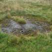
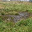
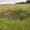
Three holdfasts, a service track and what may be an associated building, are all that has been observed of a temporary Cold War Anti-Aircraft Battery visible on a Fairey Surveys Ltd air photograph (FSL/7825 1103), flown on 26 August 1978 and noted in a document held by the National Archives at Kew (WO 106/5912).
The holdfasts, which are situated in rough pasture about 50m NW of an Electricity Switching Station, are linked by a grass-grown service track that connects to the World War II Starfish (NS46SW 196) to the N. A fourth holdfast, originally the most easterly, was excavated before the Switching Station was built (Kirby 2005); but the others, which are scarped back into the rising ground on the NE (NS 44705 60252, NS 44718 60228 and NS 44739 60210), measure 4m in diameter. Although the central holdfast is largely grass-grown, each can be seen to retain its metal fittings and a cable trench.
The building (NS 44856 60257), which may have been a store, is situated about 140m ENE, at right angles to the World War II Starfish service track (NS456SW 196). Only the grass-grown concrete floor survives and this measures 15m from N to S by 5m transversely. Its character and location are similar to the building situated about 90m SSW of the temporary Cold War anti-aircraft battery at Peathill Wood (NS57NE 112).
Visited by HES, Survey and Recording (ATW, AKK) 25 August 2017.

