|
Prints and Drawings |
DC 46224 |
Records of the Royal Commission on the Ancient and Historical Monuments of Scotland (RCAHMS), Edinbu |
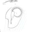
RCAHMS survey drawing; Earnagream, Canna, souterrain and mound: plan and sections.
|
9/3/1996 |
Item Level |
|
|
Prints and Drawings |
DC 46225 |
Records of the Royal Commission on the Ancient and Historical Monuments of Scotland (RCAHMS), Edinbu |
RCAHMS survey drawing; Earnagream, Canna, souterrain and mound: sections. (Preliminary field survey drawings: not to scale)
|
9/3/1996 |
Item Level |
|
|
Prints and Drawings |
DC 46226 |
Records of the Royal Commission on the Ancient and Historical Monuments of Scotland (RCAHMS), Edinbu |
RCAHMS survey drawing; Earnagream, Canna, souterrain and mound: sections. (Preliminary field survey drawings: not to scale)
|
9/3/1996 |
Item Level |
|
|
Prints and Drawings |
DC 46227 |
Records of the Royal Commission on the Ancient and Historical Monuments of Scotland (RCAHMS), Edinbu |
RCAHMS survey drawing; Earnagream, Canna, souterrain and mound: sections. (Preliminary field survey drawings: not to scale)
|
9/3/1996 |
Item Level |
|
|
Prints and Drawings |
DC 46228 |
Records of the Royal Commission on the Ancient and Historical Monuments of Scotland (RCAHMS), Edinbu |
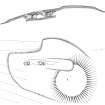
RCAHMS publication drawing; Beinn Tighe (Earnagream), Canna, souterrain and mound: plan and section.
|
1997 |
Item Level |
|
|
Digital Files (Non-image) |
GV 006088 |
Records of the Royal Commission on the Ancient and Historical Monuments of Scotland (RCAHMS), Edinbu |
Plan and section of Beinn Tighe souterrain. HES publication illustration |
5/2016 |
Item Level |
|
 |
On-line Digital Images |
SC 1526627 |
Records of the Royal Commission on the Ancient and Historical Monuments of Scotland (RCAHMS), Edinbu |
Plan and section of Beinn Tighe souterrain. HES publication illustration. HES publication illustration, 400dpi copy of GV006088. |
5/2016 |
Item Level |
|
 |
On-line Digital Images |
SC 1565462 |
Records of the Royal Commission on the Ancient and Historical Monuments of Scotland (RCAHMS), Edinbu |
RCAHMS publication drawing; Earnagream, Canna, souterrain and mound: plan and section.
|
1997 |
Item Level |
|
|
Digital Files (Non-image) |
DX 001432 |
Records of the Royal Commission on the Ancient and Historical Monuments of Scotland (RCAHMS), Edinbu |
RCAHMS Structures Database - Canna |
1994 |
Item Level |
|
|
Digital Files (Non-image) |
TM 000323 |
Records of the Royal Commission on the Ancient and Historical Monuments of Scotland (RCAHMS), Edinbu |
Zip file containing the final survey linework dxf file for the RCAHMS National Archaeological Survey of Canna 1994, OS Antiquity model dxf files and a document detailing the files and the survey methodology. |
1996 |
Item Level |
|
|
Photographs and Off-line Digital Images |
A 13076 |
Records of the Ordnance Survey, Southampton, Hampshire, England |
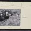
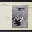
From S. |
1972 |
Item Level |
|
|
Photographs and Off-line Digital Images |
A 13075 |
Records of the Ordnance Survey, Southampton, Hampshire, England |
From S. |
1972 |
Item Level |
|
 |
On-line Digital Images |
SC 2263881 |
Records of the Ordnance Survey, Southampton, Hampshire, England |
From S. |
1972 |
Item Level |
|
 |
On-line Digital Images |
SC 2263882 |
Records of the Ordnance Survey, Southampton, Hampshire, England |
From S. |
1972 |
Item Level |
|
 |
On-line Digital Images |
SC 2358181 |
Records of the Ordnance Survey, Southampton, Hampshire, England |
Canna, Beinn Tighe, NG20NW 2, Ordnance Survey index card, Recto |
1958 |
Item Level |
|
 |
On-line Digital Images |
SC 2358182 |
Records of the Ordnance Survey, Southampton, Hampshire, England |
Canna, Beinn Tighe, NG20NW 2, Ordnance Survey index card, page number 1, Recto |
1958 |
Item Level |
|
 |
On-line Digital Images |
SC 2358183 |
Records of the Ordnance Survey, Southampton, Hampshire, England |
Canna, Beinn Tighe, NG20NW 2, Ordnance Survey index card, page number 2, Verso |
1958 |
Item Level |
|
 |
On-line Digital Images |
SC 2358184 |
Records of the Ordnance Survey, Southampton, Hampshire, England |
Canna, Beinn Tighe, NG20NW 2, Ordnance Survey index card, page number 1, Recto |
1958 |
Item Level |
|
 |
On-line Digital Images |
SC 2358185 |
Records of the Ordnance Survey, Southampton, Hampshire, England |
Canna, Beinn Tighe, NG20NW 2, Ordnance Survey index card, page number 2, Verso |
1958 |
Item Level |
|
|
Digital Files (Non-image) |
TM 002344 |
Records of the Royal Commission on the Ancient and Historical Monuments of Scotland (RCAHMS), Edinbu |
Zip file containing the final survey linework for the RCAHMS National Archaeological Survey of Canna 1994. Shapefile and Geojson format. |
1996 |
Item Level |
|
|
Photographs and Off-line Digital Images |
BS 162 CS |
Historic Scotland Archive Project |
Maritime photographs: General views over Canna by the Archaeological Diving Unit (ADU).
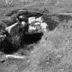
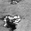
Includes ‘King of Norway’s Grave – structure; Tarbert Bay – mound; Beinn Tighe – souterrain; Dun Channa – fort; Losaid Eag – enclosure and Sanday, Am Mialagan – cottage. |
|
Batch Level |
|
|
All Other |
551 166/1/1 |
Records of the Ordnance Survey, Southampton, Hampshire, England |
Archaeological site card index ('495' cards) |
1947 |
Sub-Group Level |
|


