 |
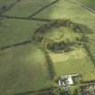
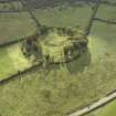
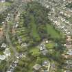
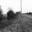
On-line Digital Images |
DP 018852 |
RCAHMS Aerial Photography Digital |
Oblique aerial view centred on the course of the Antonine Wall and the site of the adjoining Roman fort and possible Roman fortlet, taken from the ESE. |
10/11/2006 |
Item Level |
|
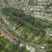 |
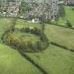
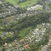
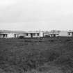
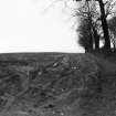
On-line Digital Images |
DP 018853 |
RCAHMS Aerial Photography Digital |
Oblique aerial view centred on the course of the Antonine Wall with the housing adjacent, taken from the SE. |
10/11/2006 |
Item Level |
|
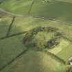 |
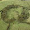
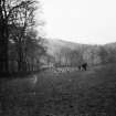
On-line Digital Images |
DP 020953 |
RCAHMS Aerial Photography Digital |
Oblique aerial view centred on the course of the Antonine Wall and the site of the adjoining Roman fort and possible Roman fortlet, taken from the SSE. |
8/9/2006 |
Item Level |
|
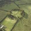 |
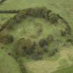
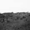
On-line Digital Images |
DP 020954 |
RCAHMS Aerial Photography Digital |
Oblique aerial view centred on the course of the Antonine Wall and the site of the adjoining Roman fort and possible Roman fortlet, taken from the ENE. |
8/9/2006 |
Item Level |
|
 |
On-line Digital Images |
DP 020955 |
RCAHMS Aerial Photography Digital |
Oblique aerial view centred on the course of the Antonine Wall and the site of the adjoining Roman fort and possible Roman fortlet, taken from the NE. |
8/9/2006 |
Item Level |
|
 |
On-line Digital Images |
DP 020956 |
RCAHMS Aerial Photography Digital |
Oblique aerial view centred on the course of the Antonine Wall and the site of the adjoining Roman fort and possible Roman fortlet, taken from the W. |
8/9/2006 |
Item Level |
|
 |
On-line Digital Images |
DP 020957 |
RCAHMS Aerial Photography Digital |
Oblique aerial view centred on the course of the Antonine Wall and the site of the adjoining Roman fort and possible Roman fortlet, taken from the SSW. |
8/9/2006 |
Item Level |
|
 |
On-line Digital Images |
DP 020958 |
RCAHMS Aerial Photography Digital |
ESE oblique aerial view of the course of the Antonine Wall,Castlehill Roman Fort and possible fortlet. |
8/9/2006 |
Item Level |
|
 |
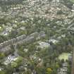
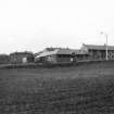
On-line Digital Images |
DP 020959 |
RCAHMS Aerial Photography Digital |
Oblique aerial view centred on the course of the Antonine Wall with the housing adjacent, taken from the ESE. |
8/9/2006 |
Item Level |
|
 |
On-line Digital Images |
DP 020960 |
RCAHMS Aerial Photography Digital |
NE oblique aerial view of the course of the Antonine Wall at Bearsden. |
8/9/2006 |
Item Level |
|
 |
On-line Digital Images |
DP 020963 |
RCAHMS Aerial Photography Digital |
General oblique aerial view centred on the site of the Roman fort and the excavated Roman bath-house with the course of the Antonine Wall adjacent, taken from the SW. |
8/9/2006 |
Item Level |
|
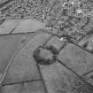 |
On-line Digital Images |
SC 1062368 |
RCAHMS Aerial Photography |
Oblique aerial view centred on the remains of the Roman fort and the course of the Antonine Wall, taken from the WSW. |
28/7/2003 |
Item Level |
|
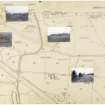 |
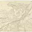
On-line Digital Images |
DP 051429 |
Records of the Royal Commission on the Ancient and Historical Monuments of Scotland (RCAHMS), Edinbu |
Antonine Wall Ordnance Survey 1954-57 working sheets map sheet 4 |
c. 1957 |
Item Level |
|
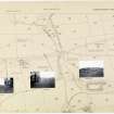 |
On-line Digital Images |
DP 051431 |
Records of the Royal Commission on the Ancient and Historical Monuments of Scotland (RCAHMS), Edinbu |
Antonine Wall Ordnance Survey 1954-57 working sheets map sheet 5 |
c. 1957 |
Item Level |
|
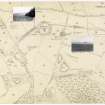 |
On-line Digital Images |
DP 051432 |
Records of the Royal Commission on the Ancient and Historical Monuments of Scotland (RCAHMS), Edinbu |
Antonine Wall Ordnance Survey 1954-57 working sheets map sheet 6 |
c. 1957 |
Item Level |
|
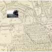 |
On-line Digital Images |
DP 051433 |
Records of the Royal Commission on the Ancient and Historical Monuments of Scotland (RCAHMS), Edinbu |
Antonine Wall Ordnance Survey 1954-57 working sheets map sheet 7 |
c. 1957 |
Item Level |
|
 |
On-line Digital Images |
DP 051434 |
Records of the Royal Commission on the Ancient and Historical Monuments of Scotland (RCAHMS), Edinbu |
Antonine Wall Ordnance Survey 1954-57 working sheets map sheet 8 |
c. 1957 |
Item Level |
|
 |
On-line Digital Images |
DP 051478 |
Records of the Royal Commission on the Ancient and Historical Monuments of Scotland (RCAHMS), Edinbu |
Antonine Wall Ordnance Survey 1954-57 working sheets map sheet 4 |
c. 1957 |
Item Level |
|
 |
On-line Digital Images |
DP 051479 |
Records of the Royal Commission on the Ancient and Historical Monuments of Scotland (RCAHMS), Edinbu |
Antonine Wall Ordnance Survey 1954-57 working sheets map sheet 4 |
c. 1957 |
Item Level |
|
 |
On-line Digital Images |
DP 051480 |
Records of the Royal Commission on the Ancient and Historical Monuments of Scotland (RCAHMS), Edinbu |
Antonine Wall Ordnance Survey 1954-57 working sheets map sheet 4 |
c. 1957 |
Item Level |
|
 |
On-line Digital Images |
DP 051481 |
Records of the Royal Commission on the Ancient and Historical Monuments of Scotland (RCAHMS), Edinbu |
Antonine Wall Ordnance Survey 1954-57 working sheets map sheet 4 |
c. 1957 |
Item Level |
|
 |
On-line Digital Images |
DP 051482 |
Records of the Royal Commission on the Ancient and Historical Monuments of Scotland (RCAHMS), Edinbu |
Antonine Wall Ordnance Survey 1954-57 working sheets map sheet 5 |
c. 1957 |
Item Level |
|
 |
On-line Digital Images |
DP 051483 |
Records of the Royal Commission on the Ancient and Historical Monuments of Scotland (RCAHMS), Edinbu |
Antonine Wall Ordnance Survey 1954-57 working sheets map sheet 5 |
c. 1957 |
Item Level |
|
 |
On-line Digital Images |
DP 051484 |
Records of the Royal Commission on the Ancient and Historical Monuments of Scotland (RCAHMS), Edinbu |
Antonine Wall Ordnance Survey 1954-57 working sheets map sheet 5 |
c. 1957 |
Item Level |
|


