
Scheduled Maintenance
Please be advised that this website will undergo scheduled maintenance on the following dates: •
Tuesday 3rd December 11:00-15:00
During these times, some services may be temporarily unavailable. We apologise for any inconvenience this may cause.
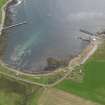
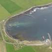
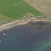
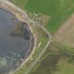
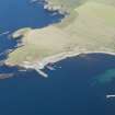
South Ronaldsay, Burwick


Farmhouse (18th Century), Farmstead (18th Century)
Site Name South Ronaldsay, Burwick
Classification Farmhouse (18th Century), Farmstead (18th Century)
Alternative Name(s) Burwick Farm, Including Ancillary Buildings
Canmore ID 107148
Site Number ND48SW 12
NGR ND 43845 84198
Datum OSGB36 - NGR
Permalink http://canmore.org.uk/site/107148


- Council Orkney Islands
- Parish South Ronaldsay
- Former Region Orkney Islands Area
- Former District Orkney
- Former County Orkney
ND48SW 12 43845 84198
Mid 19th century stone built farmhouse with steading range of outbuildings, which may possibly be earlier. The farmhouse retains a slated roof whilst the outbuildings including an L-shaped in plan range are now unroofed.
The farmstead and outbuildings are depicted as roofed on the 1sr Edition of the OS 6-inch map (Orkney and Shetland (Orkney) 1882, sheets cxxvi) and annotated 'Burwick'. The Object Name Book of the Ordnance Survey (ONB), describes the farm as 'Applies to a substantial farmhouse and offices which is situated on the Southe=west side of South Ronaldsy and at the north end of Burwick, the property of the Earl of Zetland'.
Name Book 1880.
2 storey 5 bay harled asymmetrical farmhouse with a single storey lean-to projection forming an L-plan. The east elevation of the farmhouse features regular 12-pane fenestration to the centre, with doors to the centre and left. A 5 bay rubble range projects forward from the left with 3 windows and 2 doors. The west elevation to the rear is irregularly fenestrated. The south elevation features a window at each floor in the left-hand bay, surmounted by a wallhead stack. A wide U-plan court sits to the north of the farmhouse. The south arm rises to a single storey with attic and was once the grain store. A forestair sits at the east gable, whilst a central door and small windows sit to the south. The north elevation features a wide doorway to the outer right. The central ranges comprises a 3 bay byre with central boarded door and flanking windows at the east elevation. A lower byre sits to the right. The north arm comprises a single storey byre with irregular southern openings and a boarded eastern door. A further single storey byre with attic sits over the road to the east, whilst a small rubble lean-to outhouse sits to the rear of the farmhouse. The ancillary buildings and farmhouse projection retain traditional graded stone tiles. The farmhouse interior features timber architraved doorways and skirting boards, and exposed timber rafters and braces. The central byre retains its timber hay racks with flagstone stall dividers.
The elegantly proportioned farmhouse and large rubble farm buildings form an interesting example of Orkney rural vernacular architecture. Much larger in scale than a traditional steading, and arranged in an open plan rather than as a parallal dwelling house and associated byres, it represents farming on a much grander scale. (Historic Scotland)

