
Canna, Lag A' Bhaile


Township (Period Unassigned)
Site Name Canna, Lag A' Bhaile
Classification Township (Period Unassigned)
Alternative Name(s) Canna Harbour
Canmore ID 10706
Site Number NG20NE 20
NGR NG 277 054
Datum OSGB36 - NGR
Permalink http://canmore.org.uk/site/10706


- Council Highland
- Parish Small Isles
- Former Region Highland
- Former District Lochaber
- Former County Inverness-shire
NG20NE 20 277 054.
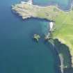
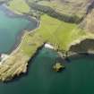
The British Fisheries map of Canna Harbour of 1788 shows nine houses above Coroghon Bay in the flat valley still called Lagg a' Bhaile. The inhabitants were moved to Sanday for the purpose of making kelp or fishing and the buildings do not appear on a map of 1805.
J L Campbell 1984.
(Classification amended to township). Nothing can now be seen of the cluster of nine roofed buildings depicted in 1788 at Lag a? Bhaile on the British Fisheries Society Plan of Canna Harbour. About twenty buildings are shown at this location on a sketch of Canna Harbour dated to a year earlier and drawn by Lt. Pierce of the British Fisheries Society during their visit to the island; Campbell suggests that this is drawn from and that these buildings may belong to the crofters who were moved to Greod on Sanday (for which see NG20SE 24). Two roofed buildings are shown in roughly the same location on an estate map of 1805, but it seems likely that these are later in date, the longer and northern of the two being Coroghon Barn (NG20NE 26) which is believed to have been built in the late eighteenth century.
Information from RCAHMS (ARG), 13 August 1996.
J L Campbell 1984.

