
Canna, Eilean Gille Mhairtein


Chapel (Period Unassigned)(Possible), Enclosure(S) (Period Unassigned)
Site Name Canna, Eilean Gille Mhairtein
Classification Chapel (Period Unassigned)(Possible), Enclosure(S) (Period Unassigned)
Alternative Name(s) Canna Harbour
Canmore ID 10699
Site Number NG20NE 14
NGR NG 2676 0508
Datum OSGB36 - NGR
Permalink http://canmore.org.uk/site/10699


- Council Highland
- Parish Small Isles
- Former Region Highland
- Former District Lochaber
- Former County Inverness-shire
NG20NE 14 2676 0508.
(NG 2676 0508) Enclosure (Visible on RAF air photograph 106G/Scot/UK 537: 3066-7; flown 7 May 1946) - possible chapel site (OS 6" map, annotated A L F Rivet 1961).
(Undated) information from OS archaeology record card.
On Eilean Ghille Mhairtein is a roughly oval enclosure measuring 17.0m E-W by 10.5m between the centres of a wall spread to 1.5m. The E end is mutilated. Date and purpose uncertain.
About 20.0m to the E are traces of another enclosure measuring 9.0m in diameter with the S side eroded. There are two boat noosts at the E end of the island. There is no ground evidence for, nor any local tradition of, a chapel on this island.,
Visited by OS (I S S), 27 May 1972.
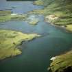
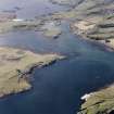
A subrectangular enclosure lies on gently sloping ground at the W end of Eilean Gille Mhartein, a tidal island in the bay between Canna and Sanday. It measures at least 12.3m from E to W by 9.2m transversely within a grass-grown rubble wall spread up to 1.3m in thickness and 0.4m in height; the E end of the enclosure has been disturbed. No trace of a second enclosure recorded by the OS to the E was discovered during the course of the survey, nor of a chapel that is said to have stood on the island.
(Canna 32).
Visited by RCAHMS (ARG, IMS), 2 May 1994.
Field Visit (27 May 1972)
On Eilean Ghille Mhairtein is a roughly oval enclosure measuring 17.0m E-W by 10.5m between the centres of a wall spread to 1.5m. The E end is mutilated. Date and purpose uncertain.
About 20.0m to the E are traces of another enclosure measuring 9.0m in diameter with the S side eroded. There are two boat noosts at the E end of the island. There is no ground evidence for, nor any local tradition of, a chapel on this island.,
Visited by OS (I S S), 27 May 1972.
Field Visit (2 May 1994)
A subrectangular enclosure lies on gently sloping ground at the W end of Eilean Gille Mhartein, a tidal island in the bay between Canna and Sanday. It measures at least 12.3m from E to W by 9.2m transversely within a grass-grown rubble wall spread up to 1.3m in thickness and 0.4m in height; the E end of the enclosure has been disturbed. No trace of a second enclosure recorded by the OS to the E was discovered during the course of the survey, nor of a chapel that is said to have stood on the island.
(Canna 32).
Visited by RCAHMS (ARG, IMS), 2 May 1994.

