
Limekilnburn Battery


Anti Aircraft Battery (20th Century), Military Camp (20th Century)
Site Name Limekilnburn Battery
Classification Anti Aircraft Battery (20th Century), Military Camp (20th Century)
Alternative Name(s) S10; Clyde Aa Defences; Thorniehill
Canmore ID 106352
Site Number NS75SW 26
NGR NS 70551 51046
Datum OSGB36 - NGR
Permalink http://canmore.org.uk/site/106352


- Council South Lanarkshire
- Parish Hamilton (South Lanarkshire)
- Former Region Strathclyde
- Former District Hamilton
- Former County Lanarkshire
NS75SW 26 70551 51046
In a field to the S of the post-war anti-aircraft battery (NS75SW 25). A four gun 3.7/4.5-inch AA battery with the command post and gun laying platform nearby, constructed of brick and in quite good condition.
Information from Mr J Guy, August 1996
The following site in South Lanarkshire has been identified and recorded during fieldwork carried out by the staff of West of Scotland Archaeology Service. Full details are available in the WoSAS SMR.
NS 7055 5103 Limekilnburn Anti-aircraft battery.
(centre)
West of Scotland Archaeology Service 1997
This site has been recorded by Mr J Guy as part of the Strathclyde Survey.
J Guy 2001; NMRS MS 810/11, Part 3, 246-7; Vol.2 (appendix), 25
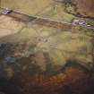
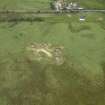
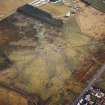
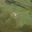
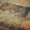
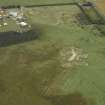
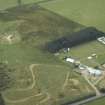
The four gun-emplacement battery set amid an area of rig-and-furrow cultivation is visible on oblique digital air photographs (RCAHMS 2007), which show the gun positions, command post and the radar ramp for a gun laying radar set.
National Record Office (former Public Record Office) archive shows that this gun battery remained unarmed from June 1942 to December 1945, no records are noted for the manning. In addition there are no records of the type of radar supplied.
Field Visit (6 July 2017)
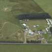
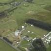
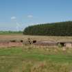
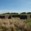
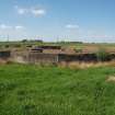
This heavy anti-aircraft battery is situated in rough pasture about 175m N of a minor public road leading W towards Boghead from the Strathaven Road. It comprises four gun emplacements, a command post, a radar ramp that once formed the nucleus of a GL matt and some building foundations associated with the camp; and It was one of at least 43 such batteries that were constructed to protect the industries in the centre of Glasgow and along the banks of the River Clyde from aerial attack by the Luftwaffe during WWII.
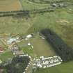
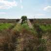
The battery is approached from the public road by a grass-grown track which leads N over rig and furrow for about 150m before passing between the gun emplacement and the command post, where it turns sharply NE to run on towards the camp. All the gun-pits are planned around the circumference of a circle with a radius of 35m pivoted on a NW to SE axis.
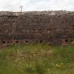
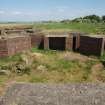
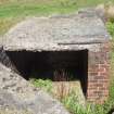
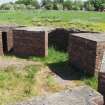
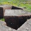
The four gun-pits (NS 70584 51060, NS 70582 51030, NS 70557 51009, NS 70529 51019) can be separated into two pairs, one on the E arc of the circle and one on the SSW. All are of the same design, but none are protected by an earthen bund. They are irregular dodecahedrons on plan and measure 14m in diameter within cement-washed, brick blast walls 0.5m thick and 1.92m high. Single gateways accounting for the three missing sides, measure 3.5m wide and face towards the command post. In each gun-pit, five ammunition lockers measuring 1.78m by 1.75m transversely within walls 0.48m thick and 1.6m high, are built against the inner side of the blast wall. They are symmetrically arranged with one positioned opposite the entrance. All have flat concrete roofs weatherproofed with bitumen, raised concrete floors and one open side. Two more diametrically opposed ammunition lockers, measuring 1.78m by 1.34m within brick walls 0.48m-0.74m thick and 1.6m high open on to the centre of the gun-pit. Behind these is a crew shelter, situated outside the line of the blast wall, to which access is had from the gun-pit. They are rectangular on plan and measure 4.7m by 2.25m transversely within brick walls 0.48m thick and 2.17m high. Circular perforations in the flat concrete roof may have been provided for the chimney of a stove, while an air brick just below the roofline at one end vented the interior. Where not grass-grown, each concrete hardstanding can be seen to have had a circular arrangement of ten metal fittings for the holdfast measuring 2.16m in diameter.
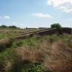
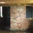
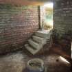
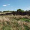
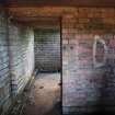
The command post (NS 70551 51046), which is largely brick-built and partly buried within an earthen bund, is situated NW of the track about 20m from each gun-pit. It is rectangular on plan and measures 20.1m from NE to SW by 7.78m transversely. A concrete terrace on the SE (modified by the addition of a length brick wall across its frontage) supports the platforms for the height finder, the spotting telescope and the predictor. Seven ducts emerging from the SE wall transmitted the cabling to each of the gun pits. At the back of the terrace is a porch that shelters a flight of steps leading down to the control rooms. These occupy a block attached to the NW, as well as wings to its NE and SW. They are protected by a rotting flat roof of reinforced cast concrete. The block contains two compartments – the plotting room and the space occupied by the retransmission unit, while the wings each contain two further compartments for use as offices or stores. The plotting room is lit by two windows looking out on to the terrace, a third in the NW wall and a fourth connecting with one of the NE offices. Rectangular ducts high in the NW wall provide ventilation, while two further windows in it also light the wings. Stairs at their far end ascend to the terrace where they emerge from hatches. The interiors of all the rooms have been stripped of their fittings, but a boiler attached to the rear of the building would have provided central heating. A small shelter accessed from the SE and protecting a flight of descending steps has been attached to the end of the NE wing.
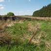
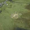
The gun laying radar (NS 70524 51122), which once lay at the centre of a GL mat, is situated in marshy ground 75m NNW of the command post. The wire mesh is missing, but some of the iron stakes that supported it survive. The ramp, which measures 11m from NNE to SSW by 2.4m transversely over two parallel, cement-washed, brick walls 0.6m thick, runs up to a platform 1.5m high raised over two hollow rectangular compartments. These together measure 5.5m from NNE to SSW by 2.4m transversely over brick walls which are supported on the WNW and ESE by three brick extensions – that in the centre being longer than those to either side.
What remains of the camp, occupying an area of about 1ha, is situated NE of the battery, where the foundations of least 17 rectangular buildings are visible (NS 70623 51063, NS 70261 51081, NS 70668 51141, NS 70683 51110, NS 70685 51089, NS 70665 51084, NS 70662 51047, NS 70668 51036, NS 70644 51172, NS 70649 51187, NS 70643 51194, NS 70646 51200, NS 70647 51210, NS 70650 51217, NS 70653 51225, NS 70655 51233, NS 70659 51247). Most are grass-grown and raised above the general level of the ground. Their footprints vary from 6.6m by 2.9m transversely to 32.75m by 11.9m transversely.
Visited by HES, Survey and Recording (ATW, AKK, ARG) 6 July 2017.

