 |
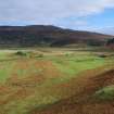
On-line Digital Images |
SC 729709 |
Records of the Royal Commission on the Ancient and Historical Monuments of Scotland (RCAHMS), Edinbu |
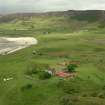
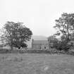
Copy of colour photograph showing Laig farmhouse and Cleadale, Isle of Eigg from S. |
2001 |
Item Level |
|
 |
On-line Digital Images |
SC 729710 |
Records of the Royal Commission on the Ancient and Historical Monuments of Scotland (RCAHMS), Edinbu |
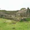
Copy of colour photograph showing Laig farmhouse, Isle of Eigg. |
c. 2001 |
Item Level |
|
 |
On-line Digital Images |
SC 729729 |
Records of the Royal Commission on the Ancient and Historical Monuments of Scotland (RCAHMS), Edinbu |
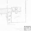
400dpi scan of DC48890 pencil survey drawing (plan) of plan of Laig farmhouse, Isle of Eigg. |
5/7/1998 |
Item Level |
|
 |
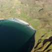
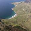
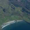
On-line Digital Images |
DP 109454 |
RCAHMS Aerial Photography Digital |
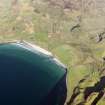
General oblique aerial view of the Bay of Laig, Eigg, taken from the W. |
30/4/2011 |
Item Level |
|
 |
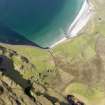
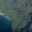
On-line Digital Images |
DP 109455 |
RCAHMS Aerial Photography Digital |
General oblique aerial view of the Bay of Laig, Eigg, taken from the WNW. |
30/4/2011 |
Item Level |
|
 |
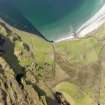
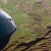
On-line Digital Images |
DP 109460 |
RCAHMS Aerial Photography Digital |
Oblique aerial view of the Bay of Laig, Eigg, taken from the SSE. |
30/4/2011 |
Item Level |
|
 |
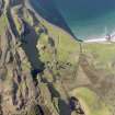
On-line Digital Images |
DP 109462 |
RCAHMS Aerial Photography Digital |
Oblique aerial view of the Bay of Laig, Eigg, taken from the SSE. |
30/4/2011 |
Item Level |
|
 |
On-line Digital Images |
DP 109463 |
RCAHMS Aerial Photography Digital |
Oblique aerial view of the Bay of Laig, Eigg, taken from the SSE. |
30/4/2011 |
Item Level |
|
 |
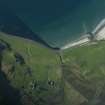
On-line Digital Images |
DP 109466 |
RCAHMS Aerial Photography Digital |
General oblique aerial view of the N end of Eigg centred on Bay of Laig and Cleadale, taken from the S. |
30/4/2011 |
Item Level |
|
 |
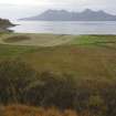
On-line Digital Images |
DP 192440 |
Dr Colin and Dr Paula Martin |
Aerial view from the SW. The farm of Laig is at lower centre with the former loch beyond it, indicated by uncultivated ground. Sròn Laimhrige (Rock of the Landing Place) is on the extreme right, above the small loch. (Colin Martin) |
c. 2014 |
Item Level |
|
 |
On-line Digital Images |
DP 192441 |
Dr Colin and Dr Paula Martin |
Aerial view from the SE. The farm of Laig is at lower centre. The northern part of the former loch is indicated by uncultivated ground to its right. Between the farm and the shore, on the raised beach, a complex of small square enclosures set in linear patterns is believed to be a Pictish cemetery. (Colin Martin) |
c. 2014 |
Item Level |
|
 |
On-line Digital Images |
DP 192442 |
Dr Colin and Dr Paula Martin |
Aerial view from the SW. The farm of Laig is lower right of centre with the former loch beyond it, indicated by uncultivated ground. Sròn Laimhrige (Rock of the Landing Place) is at top right, above the small loch. (Colin Martin) |
c. 2014 |
Item Level |
|
 |
On-line Digital Images |
DP 192443 |
Dr Colin and Dr Paula Martin |
Aerial view from the N. The farm of Laig is towards the right with the former loch to its left, indicated by uncultivated ground. Sròn Laimhrige (Rock of the Landing Place) is at top centre, topped by a triangular wood. (Colin Martin) |
c. 2014 |
Item Level |
|
 |
On-line Digital Images |
DP 192444 |
Dr Colin and Dr Paula Martin |
Laig Farm is at centre right, with the former loch beyond it. Sròn Laimhrige (Rock of the Landing Place) is the ridge above and beyond the farm. In the foreground left of centre is the raised beach on which are the remains of what is believed to be a Pictish cemetery.(Colin Martin) |
c. 2014 |
Item Level |
|
 |
On-line Digital Images |
DP 192445 |
Dr Colin and Dr Paula Martin |
Site of the former loch at Laig, indicated by uncultivated ground, from Sròn Laimhrige (Rock of the Landing Place). Looking towards Laig Bay with Rum in the background. (Colin Martin) |
c. 2014 |
Item Level |
|
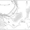 |
On-line Digital Images |
DP 192446 |
Dr Colin and Dr Paula Martin |
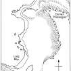
Location of the former loch at Laig, shown hatched. (Colin Martin) |
c. 2014 |
Item Level |
|
 |
On-line Digital Images |
DP 192447 |
Dr Colin and Dr Paula Martin |
The NW part of Eigg, showing the relationship between Laig, Sròn Laimhrige (Rock of the Landing Place), and Dùnan an Thalasgair. The latter is believed to have been the site of a watch-post connected by fire-signal with a post at Rubh’ an Dùnain on Skye. (Colin Martin) |
c. 2014 |
Item Level |
|
 |
On-line Digital Images |
DP 192448 |
Dr Colin and Dr Paula Martin |
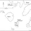
The locations of Dùnan an Thalasgair on Eigg and Rubh’ an Dùnain on Skye, where watch-posts are believed to have been established. (Colin Martin) |
c. 2014 |
Item Level |
|
 |
On-line Digital Images |
SC 1504633 |
Records of the Royal Commission on the Ancient and Historical Monuments of Scotland (RCAHMS), Edinbu |
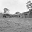
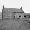
View from SE |
17/9/1998 |
Item Level |
|
 |
On-line Digital Images |
SC 1504634 |
Records of the Royal Commission on the Ancient and Historical Monuments of Scotland (RCAHMS), Edinbu |
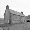
General view from W |
17/9/1998 |
Item Level |
|
 |
On-line Digital Images |
SC 1504635 |
Records of the Royal Commission on the Ancient and Historical Monuments of Scotland (RCAHMS), Edinbu |
View from WNW |
17/9/1998 |
Item Level |
|
 |
On-line Digital Images |
SC 1504636 |
Records of the Royal Commission on the Ancient and Historical Monuments of Scotland (RCAHMS), Edinbu |
View from NW |
17/9/1998 |
Item Level |
|
 |
On-line Digital Images |
SC 1504637 |
Records of the Royal Commission on the Ancient and Historical Monuments of Scotland (RCAHMS), Edinbu |
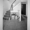
View of stair hall from E |
17/9/1998 |
Item Level |
|
 |
On-line Digital Images |
SC 1504638 |
Records of the Royal Commission on the Ancient and Historical Monuments of Scotland (RCAHMS), Edinbu |
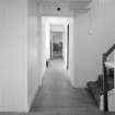
View of hallway from N |
17/9/1998 |
Item Level |
|


