
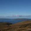
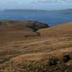
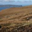
Sanday


General View
Site Name Sanday
Classification General View
Alternative Name(s) Canna
Canmore ID 105718
Site Number NG20SE 85
NGR NG 27 04
Datum OSGB36 - NGR
Permalink http://canmore.org.uk/site/105718


- Council Highland
- Parish Small Isles
- Former Region Highland
- Former District Lochaber
- Former County Inverness-shire
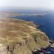
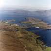
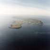
SANDAY Attached to Canna by a footbridge, Sanday protrudes from its mother isle like a jawbone hinged ajar, embracing within its maw a sheltered harbour and inner tidal flats. It is here that the majority of the croft houses still stand - by the time of the worst clearance in 1851, Sanday supported the majority of Canna's impoverished population.
Taken from "Western Seaboard: An Illustrated Architectural Guide", by Mary Miers, 2008. Published by the Rutland Press http://www.rias.org.uk


