
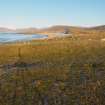
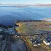
Harris, Borvemore


Mound (Period Unknown), Standing Stone (Prehistoric), Stone Circle (Neolithic) - (Bronze Age)
Site Name Harris, Borvemore
Classification Mound (Period Unknown), Standing Stone (Prehistoric), Stone Circle (Neolithic) - (Bronze Age)
Canmore ID 10546
Site Number NG09SW 2
NGR NG 02049 93914
Datum OSGB36 - NGR
Permalink http://canmore.org.uk/site/10546


- Council Western Isles
- Parish Harris
- Former Region Western Isles Islands Area
- Former District Western Isles
- Former County Inverness-shire
NG09SW 2 0202 9392
(NG 0202 9394) Stone Circle (NR) (Site of)
(NG 0202 9392) Standing Stone (NR)
(NG 0201 9390) Human Remains found AD. 1864 (NAT)
OS 6" map, Inverness-shire, 2nd ed., (1903).
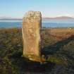
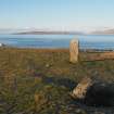
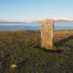
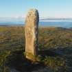
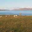
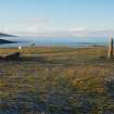
A standing stone (6' 7" high), which seems to have formed part of a stone circle, as four other pillar stones lie prostrate near it. These have all been removed from their original position, and their present arrangement gives no indication of the size of the circle.
Human remains are said to have been found in 1864.
RCAHMS 1928, visited 1914.
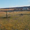
A standing stone as described by the RCAHMS. Only three prostrate 'pillar stones' can be seen nearby to the SSE, and these are smaller than the standing stone. There is no other evidence for a stone circle here.
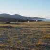
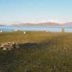
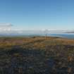
At the spot marked 'Stone Circle (Site of)' on OS 6"map (1903), some 20.0m to the NNW, is a low, amorphous flat-topped mound, about 12.0m across, composed largely of loose stones, which is possibly the remains of a cairn, but more likely due to field clearance. The flat face of the standing stone faces WSW at a right angle to this mound. No finds have been made recently.
Visited by OS (N K B), 1 July 1969.
Standing stone 186 x 97 x 17cm orientated NW/SE. 2 prostrate stones visible; one lies about 9m south of standing stone and is 126cm long, about 11m from the standing stone lies the second 230cm long and 7m E of the other prostrate stone.
Information from M Van Hoek, 1980.
Field Visit (5 June 1914)
Standing Stone, Remains of Circle, Borvemore.
About 70 yards from the shore and about 30 feet above sea-level, on cultivated ground, ½ mile south-west of Borvemore, is a standing stone facing the south-east. It measures 6 feet 7 inches in height, 2 feet 9 inches in breadth, and from 8 inches to 1 foot 7 inches in thickness. Human remains are said to have been found near it in 1864. It seems to have formed part of a stone circle, as other four pillar stones lie prostrate near it. The first of these, which is partly buried, lies 32 feet to the south and measures at least 6 feet in length, 1 foot 6 inches in breadth, and 1 foot 6 inches in thickness; the second, 40 feet to the south-east of the standing stone, is 8 feet long, 2 feet 2 inches broad, and 1 foot 3 inches thick at least; the third, about 60 feet beyond the second, is 6 feet in length and 2 feet 1 inch in breadth; and the fourth, 25 feet south-west of the third, measures 4 feet in length and over 2 feet in breadth. These stones have all been removed from their original position, and their present arrangement gives no suggestion of the size of the circle.
RCAHMS 1928, visited 5 June 1914.
OS map: Harris xvii.

