
Lerwick, 20 Commercial Street, The Lodberry


Cottage (Period Unassigned), Crane (Period Unassigned), Lodberry (18th Century), Pier (Period Unassigned), Storehouse(S) (Period Unassigned)
Site Name Lerwick, 20 Commercial Street, The Lodberry
Classification Cottage (Period Unassigned), Crane (Period Unassigned), Lodberry (18th Century), Pier (Period Unassigned), Storehouse(S) (Period Unassigned)
Alternative Name(s) Lerwick Harbour; Lodberrie
Canmore ID 1054
Site Number HU44SE 22
NGR HU 47894 41244
Datum OSGB36 - NGR
Permalink http://canmore.org.uk/site/1054


- Council Shetland Islands
- Parish Lerwick
- Former Region Shetland Islands Area
- Former District Shetland
- Former County Shetland
HU44SE 22 47894 41244
NLO: Lerwick [name: HU 475 415].
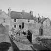
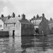
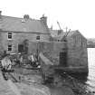
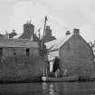
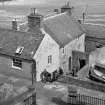
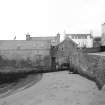
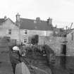
(Location cited as HU 479 413). The Lodberrie, Lerwick, late 18th or early 19th centuries. An attractive compact group of dwelling houses and stores on a pier projecting into the harbour. There is a sea-door with a wall crane, on the sea-front; cf. Stromness, Orkney.
J R Hume 1977.
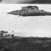
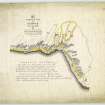
The ill-defined area of Lerwick Harbour (HU44SE 32: centred HU 47722 41345) essentially forms an extensive roadstead which comprises the waters of Bressay Sound between the narrow Northern entrance (around HU 475 445) and the broader Southern entrance (around HU 483 400). The main facilities are to be found around HU 477 414, on the W side of the Sound; recent development extends Northwards from this point.
Information from RCAHMS (RJCM), 5 October 2007.
NMRS REFERENCE:
Owner: Thomas Moncrieff, Esq.
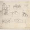
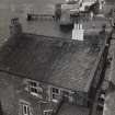
Picturesquely grouped house and stores built on lodberry, comprising single storey over concealed basement 3-bay range (former shop) to commercial street with 2-storey 3-bay house connected at right-angle to rear (N); 2-storey range (former sail loft and dry goods store at upper floor) with store and workshop at basement bounding W extent of complex, small flagged courtyard centred at N end of lodberry, 2-storey store (former wet fish store with meat and fishcuring "skeo" at upper floor) to NE corner. Harl-pointed random rubble walls.
Formerly known as Robertson's Lodberry, it was named after Bailie John Robertson who was joint agent with Charles Merrylees for the North of Scotland and Orkney and Shetland Steam Navigation Company, who owned the neighbouring "steamer" storehouse at 18 Commercial Street .
Although the (then ruinous) former shop to Commercial Street was rebuilt circa 1950 and there have been some minor changes to the fenestration, this complex remains a remarkably intact example of the commercial and domestic development of a lodberry. It is, however, most famous for the picturesque quality of the grouping, and as such is the most photographed building in Shetland. (Historic Scotland)

