
Stockiemuir


Anti Aircraft Battery (20th Century)
Site Name Stockiemuir
Classification Anti Aircraft Battery (20th Century)
Alternative Name(s) Cd14a; Clyde Postwar Aa Defences; Tamnetherskins; Quinloch Muir; Finnich
Canmore ID 105315
Site Number NS58SW 14
NGR NS 50689 82379
NGR Description Centred NS 50689 82379
Datum OSGB36 - NGR
Permalink http://canmore.org.uk/site/105315


- Council Stirling
- Parish Killearn
- Former Region Central
- Former District Stirling
- Former County Stirlingshire
NS58SW 14 centred 50698 82311
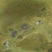
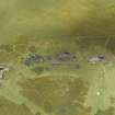
A 5.25-inch anti-aircraft battery (Mark 6 site) just N of the A809 public road S of Finnich on Stockiemuir is depicted on the latest editions of the OS map (OS 1:2500, 1:10000 map, 1978). The fact that the site does not appear on the vertical air photograph taken in 1949 (RAF 54/A/471, 3242, flown 1949), but is shown on later vertical air photographs, most notably those taken in 1954 and 1960 would suggest that this is a post-war battery.
Information from RCAHMS (DE) July 1996
One of a series of six heavy post-war 5.25 inch gun anti-aircraft batteries built between 1950 and 1951 of which five were built around Glasgow. They were designed to be fully automated with radar control. The guns were disposed of as scrap during July 1956.
Information from Mr J A Guy, May 1999; NMRS 810/7,
This site is visible on vertical, colour aerial photography (PHOTOAIR sortie A 94046; frames 6 & 7). The sortie was flown in July 1994.
Information from RCAHMS (GT) 19 May 2004
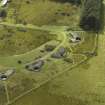
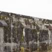
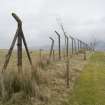
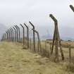
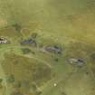
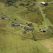
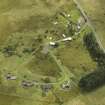
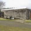
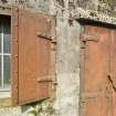
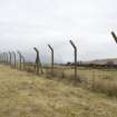
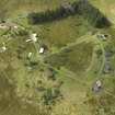
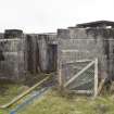
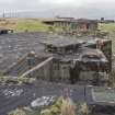
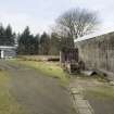
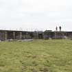
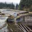
The gun site is clearly visible on a series of large scale vertical air photographs taken by the Ordnance Survey (OS/66/96, 078-080, flown 29 May 1966), which show that most of the structures, with the exception of the accommodation camp, were still standing at this date. The battery and support buildings, except the accommmodation camp were enclosed within a high fence, most of which still stands and encloses a total area of 6.73 hectares.
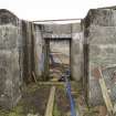
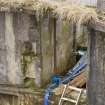
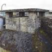
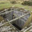
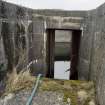
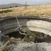
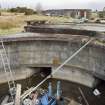
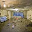
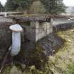
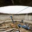
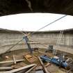
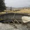
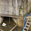
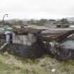
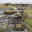
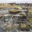
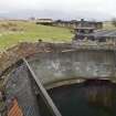
The four gun-emplacements (NS 50629 82430, NS 50670 82448, NS 50716 82453 and NS 50760 82443) are to a very different design to those built during World War II, taking a Y-shape in plan. The complete installation is visible on a series of vertical air photographs taken in 1966(ibid), which shows that one of the emplacements has been provided with some type of coating on the roof, appearing as 'black' on the image.
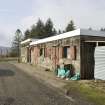
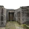
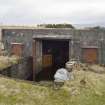
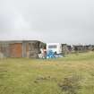
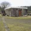
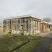
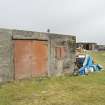
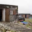
Two huts situated at the entrance gate (NS 50649 82206 and NS 50653 82228), have both been converted to dwelling houses and are now annotated 'Wayside Cottage' and Queen's View' respectively.
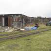
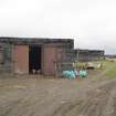
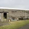
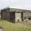
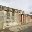
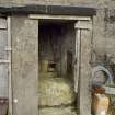
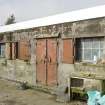
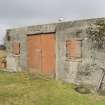
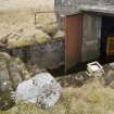
Three other buildings/huts still stand, at NS 50661 82281, NS 50679 82274 and NS 50697 82311, all of which provided technical or power support to the battery as cable trenches can be seen on the photographs leading from the emplacements to that at NS 50697 82311. The larger buildings also have darkened roofs.
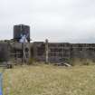
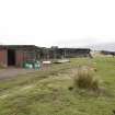
The accommodation camp, centred NS 5077 8219, consisted of six buildings or huts.
Only two other buildings can be seen on the sortie dated to 1949.
At NS 50507 82038, on the N bank of the Auchineden Burn is a square structure visible on the air photographs of 1966, but not those taken in 1949 and which is also depicted on the current OS 1:2500 scale digital map. It is likely to be linked to the battery, either for sewage of water extraction purposes.
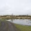
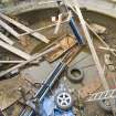
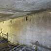
Though all the gun-emplacements and associated workings are full of water, the battery is relatively extant and provides an excellent example of a post-war fully automated gun battery.
Visited by RCAHMS (DE, GS), August 1997
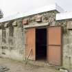
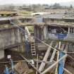
Standing Building Recording (13 February 2023 - 16 February 2023)
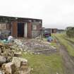
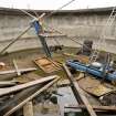
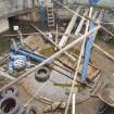
NS 50689 82379 GUARD Archaeology undertook a programme of historic building recording leading to subsequent publication of the results at the former Gun Battery at Stockiemuir Road, Blanefield, Stirlingshire prior to its conversion to domestic dwellings. The site is one of a series of six heavy post-war 5.25 inch gun anti-aircraft batteries forming part of the national defence plan, known as `Igloo’, built between 1950 and 1951 of which five were built around Glasgow. The Stockiemuir site comprises a battery of four gun emplacements spaced around 15 m apart, arranged in a shallow arc aligned east to west. Two further buildings not forming part of the development but forming part of the original complex are located 100 m to the south. The site is enclosed by a tall, dilapidated chainlink fence attached to cranked top concrete posts and has been subject to recent clearance work.
A. Hunter Blair
(Source: OASIS ID: guardarc1-513537)

