
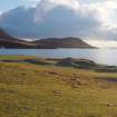
Harris, Northton


Human Remains (Prehistoric), Midden(S) (Prehistoric), Settlement (Neolithic) - (Bronze Age), Township (Period Unassigned), Beaker (Bronze Age), Food Vessel (Bronze Age), Unidentified Pottery (Neolithic)
Site Name Harris, Northton
Classification Human Remains (Prehistoric), Midden(S) (Prehistoric), Settlement (Neolithic) - (Bronze Age), Township (Period Unassigned), Beaker (Bronze Age), Food Vessel (Bronze Age), Unidentified Pottery (Neolithic)
Alternative Name(s) Rubh An Teampull; Rubh An Teampuill
Canmore ID 10502
Site Number NF99SE 2
NGR NF 9753 9123
Datum OSGB36 - NGR
Permalink http://canmore.org.uk/site/10502


- Council Western Isles
- Parish Harris
- Former Region Western Isles Islands Area
- Former District Western Isles
- Former County Inverness-shire
Field Visit (3 July 1969)
An occupation site at NF 9753 9123, as described. There are three stone built rectangular structures at NF 9752 9125, upon the dune, apparently of recent date, but no structural remains survive in the excavation. Surveyed at 1:10,000.
Visited by OS (A A) 3 July 1969.
Desk Based Assessment (1969)
NF99SE 2 9753 9123.
NF99SE 2.01 97 91 Beakers
NF 976 913. A Neolithic/Iron Age occupation site, evidenced by middens and showing four layers of occupation was partially excavated by Simpson in September 1965, at Northton, in an area of sand dunes.
The first, at a depth of 15', lay on 2' of blown sand and contained pottery closely paralleled by that from the Neolithic kilns as Eilean on Tighe (NF87SW 1) and from the chambered cairns at Unival (NF86NW 1, 4, 6) and Clettraval (NF77SW 15). Apart from a pit, the only structural feature was a roughly oval setting of boulders surrounding the crouched skeleton of a child. Other boulders occurred but were uninterpretable owing to the narrowness of the section. The radiocarbon date for this layer was 4,100 +- 140 BC.
The second midden layer lay above 1' of wind blown sand. The material ran up the side of a possibly semi-subterranean stone built house with post-holes. A pit within the house included in its contents numerous sherds of Necked Beakers as well as those of an Irish Bowl Food Vessel. The radiocarbon date for this level was 3,080 +- 150 BC.
After the abandoning of the house and a further accumulation of blown sand, the area was re-occupied by Beaker groups, but no structures were found, possibly because only a small area has been examined.
Above these deposits and again separated by blown sand were two Iron Age middens, the uppermost probably related to a series of turf-covered enclosures on top of the dune. It was hoped to continue the excavations in 1966, and expose further structures beneath the main body of the dune. Finds from the excavation were purchased for the National Museum of Antiquities of Scotland (NMAS).
D Simpson 1966; Proc Soc Antiq Scot 1967; 1968.
The radiocarbon dates for the Neolithic and Beaker levels of this site are substantially too old, a possible explanation being that the sample may have been peat-charcoal.
E W MacKie 1969.
Information from the Ordnanace Survey Index Card.
Borehole Survey (August 2001 - August 2001)
NF 9753 9123 During August 2001 fieldwork was undertaken at the prehistoric settlement site of Northton on the Toe Head Peninsula on Harris. Two seasons of excavation had previously been carried out at the site during the summers of 1965 and 1966, under the direction of Prof Derek Simpson. The results of Simpson's excavations at Northton are currently being prepared for publication, and the objective of the new programme of fieldwork was to clarify a number of outstanding issues concerning the nature and condition of the site.
There were three main facets to the programme of fieldwork: the preparation of an EDM-based topographical survey of the site; the implementation of a programme of coring for the purposes of identifying the limits of the site; and the recording of any sections of archaeological significance along the shoreline that were exposed and under threat from coastal erosion.
Reconnaissance boreholes were taken at 5m intervals along a 40m transect, and major soil horizons were noted and related along the section. Cored material was carefully checked for artefacts and ecofacts before being replaced into the borehole and turf reinstated.
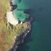
The shoreline at Toe Head Peninsula is under continuing threat from coastal erosion, and was therefore studied to identify any areas of archaeological significance being destroyed by erosion. This work identified two sections (termed the 'Small Section' and the 'Large Section' during fieldwork), which were subsequently cleaned and recorded. The Small Section had a length of 1.6m and proved to contain a sequence of natural deposits of Late Glacial to probable mid-Holocene date. The Large Section measured 6m across and contained evidence for occupation layers and a stone setting, which may represent the remains of a wall. The main occupation horizons are considered to be contemporary with the earliest of the Neolithic levels identified during Simpson's excavations at the site. A rigorous soil sampling strategy was adopted, with bulk and routine soil samples taken from every major context encountered during the cleaning of the profile, including all of the soil excavated from the occupation levels. Processing of the soil samples has revealed that they contained a substantial amount of animal bone, in addition to charred grain, hazelnut shells and fragments of flint and quartz.
A Data Structure Report for the fieldwork has been deposited in the NMRS. In addition, the project results will be incorporated into a monograph which documents the results of Simpson's 1960s excavations at the site.
Sponsor: Historic Scotland
E Murphy, M Church and D Simpson 2001
Field Visit (30 August 2009)
Erosion remains an active threat along this stretch of the coast with shells and stones revealed in shoreline sections. On the terrace above, the grass grown remains of at least three subrectangular buildings can still be seen; these probably belong to a later township.
Visited by RCAHMS (ARG,SPH) 30 August 2009
Excavation (August 2010)
NF 975 912
A small-scale excavation (1 x 5m) was undertaken in August 2010 of Mesolithic layers exposed by coastal erosion. Previous fieldwork at the site in 2001 had revealed the first radiocarbon dated Mesolithic deposits in the Western Isles beneath the later Neolithic and Beaker settlement. The extent of coastal erosion was monitored by undertaking an EDM survey of the eroding edge in relation to the existing Neolithic and Beaker earthworks and Mesolithic layers. This survey indicated that the exposed Mesolithic deposits had eroded by about 1m since 2001, but that a greater area of the Neolithic and later remains overlying the Mesolithic deposits had been completely destroyed by coastal erosion.
The excavated area of the Mesolithic deposit was 100% sampled and flotation for plant and animal remains was undertaken. No archaeological features were detected, but a sizable assemblage of Mesolithic lithics, charcoal, carbonised
plant macrofossils and animal bones was uncovered. It is proposed that this layer is a buried land surface that incorporates a palimpsest of disturbed and bioturbated hearth deposits containing fuel remnants and food waste.
Achive: To be decided
Funder: National Science Foundation of America, University of
Durham and the AHRC
R R Bishop, M J Church and P A Rowley-Conwy 2010
Ground Survey (12 September 2011 - 16 September 2011)
NF 9753 9123 A small-scale coastal erosion survey was undertaken 12–16 September 2011 of the Mesolithic buried land surface at Northton. Previous fieldwork at the site in 2001 had revealed the first radiocarbon dated Mesolithic deposits in the Western Isles eroding at the base of machair beneath the later Neolithic and Beaker settlement. A subsequent small-scale excavation undertaken in 2010 revealed a concentration of Mesolithic artefacts and ecofacts mixed within an old ground surface (DES 2010, 178).
In order to assess the spatial extent of the Mesolithic archaeology within the exposed old ground surface, a series of samples was taken at 3m intervals around the coastal edge. At each sampling location the old ground surface was surveyed, photographed, drawn and bulk samples were taken. In addition, a relic peat section c100m from the 2010 excavations was sampled to provide a palaeoenvironmental context for the archaeological remains.
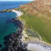
The excavated sections through the old ground surface contained varying concentrations of environmental remains and artefactual material, but no archaeological features were detected. On the NE side of the headland, the buried land surface was present in all sampling locations (up to c25m from the 2010 excavation). The absence of the old ground surface in sections over 18m to the NW of the area excavated in 2010 suggests that the Mesolithic deposits at this site are spatially restricted to an area c45–50m around the coast.
Archive: To be decided
Funders: National Science Foundation of America, Historic Scotland and Durham University
Durham University, 2011
Excavation (16 September 2011 - 17 September 2011)
NF 9734 9132 An excavation undertaken 16–17 September 2011 at Temple Bay revealed a probable Mesolithic buried land surface and associated midden deposits. The site is being actively eroded by the sea and is overlain by over 8m of machair. It appears to be part of the same early to mid-Holocene buried landscape that contains the Mesolithic dated site at Northton (DES 2010, 178). The deposits include an old ground surface of up to 0.1m in depth that is overlain by shell and ash rich midden deposits up to 0.2m deep. Approximately 4m of deposits were exposed along the coastal erosion section. The section was drawn, photographed and geo-referenced using GPS, before bulk samples were taken for laboratory analysis. Initial results have shown that the deposits contain abundant amounts of hazelnut, charcoal, shell, fish and animal bone, including a red deer antler tine, hare and bird bones. A few flint and quartz worked lithics were also recovered. No evidence of any domestic animal or plant species or pottery was recovered. Radiocarbon dates on hazelnut fragments will be obtained to test the proposed Mesolithic date for the site.
Archive: To be decided
Funders: National Science Foundation of America, Historic Scotland and Durham University
Durham University, 2011
Excavation (4 September 2012 - 7 September 2012)
NF 9734 9132 During fieldwork in 2011, a suspected Mesolithic buried land surface and midden deposits were identified eroding from a coastal erosion section at Temple Bay, below 8m of machair (DES 2011, 187). Hazelnut shell fragments were recovered from bulk samples taken from the site and submitted for radiocarbon dating. The results indicated occupation of the site ranged between 5715–5386 cal BC (SUERC-38832: 6750±30 and SUERC-38834: 6525±30 calibrated using OxCal 4.1), confirming the site as the third identified Mesolithic site in the Western Isles.
Further sampling of the eroding section was conducted 4–7 September 2012. The eroding section was cleaned back to expose a 5m stretch of deposits that were photographed, drawn and geo-referenced using GPS. Bulk samples were taken of all excavated material. In addition, multiple spot, column and Kubiëna samples were taken for geoarchaeological analysis.
The site consisted of a buried land surface, a scoop feature and associated midden deposits. The scoop cut into the old ground surface and associated midden deposits and this feature was filled with an ash spread and a shell-rich midden deposit. The Mesolithic remains were overlain by a substantial machair dune. Processing of the bulk samples recovered thousands of burnt and unburned shellfish, fish and animal bones, charred hazelnut shells and charcoal. Worked flint and quartz flakes were also retrieved. The site continues to be threatened by erosion, and the exposed section was reinstated with stones and turf.
Archive: To be decided
Funder: National Science Foundation of America, Historic Scotland and Durham University
MJ Church, Durham University
RR Bishop,
E Blake,
C Nesbitt,
A Perri,
S Piper,
PA Rowley-Conwy,
L Snape-Kennedy,
2012

