
Strath


Byre (Period Unassigned), Causeway (Period Unassigned), Clapper Bridge (Period Unassigned), Croft (Period Unassigned), Head Dyke (Post Medieval), Lazy Beds (Post Medieval), Port (Post Medieval), Stone Circle (Neolithic) - (Bronze Age), Township (Period Unassigned), Well (Period Unassigned)
Site Name Strath
Classification Byre (Period Unassigned), Causeway (Period Unassigned), Clapper Bridge (Period Unassigned), Croft (Period Unassigned), Head Dyke (Post Medieval), Lazy Beds (Post Medieval), Port (Post Medieval), Stone Circle (Neolithic) - (Bronze Age), Township (Period Unassigned), Well (Period Unassigned)
Alternative Name(s) Lonemore; Mihol; Smithstown; Strath Gairloch
Canmore ID 104954
Site Number NG77NE 13
NGR NG 790 775
NGR Description centred on NG 790 775
Datum OSGB36 - NGR
Permalink http://canmore.org.uk/site/104954


- Council Highland
- Parish Gairloch
- Former Region Highland
- Former District Ross And Cromarty
- Former County Ross And Cromarty
NG77NE 13 centred on 790 775
A crofting township, comprising 130 roofed buildings, twelve partially roofed buildings, thirty-nine unroofed structures, of which twenty-three are buildings, and some lengths of field-wall is depicted on the 1st edition of the OS 6-inch map (Ross-shire 1881, sheet xliv). One hundred and forty-four roofed buildings, two partially roofed buildings and thirty-two unroofed buildings are shown on the current edition of the OS 1:10000 map (1991).
Information from RCAHMS (AKK) 19 April 1996.
NG 799 7840 to NG 7614 8050 An archaeological desk-based assessment and walkover survey were undertaken for the proposed route of the Gairloch Water Supply Project. The following unrecorded sites were located:
Mial
NG 7991 7809 House.
NG 7994 7801 Building.
NG 7996 7830 Building.
NG 7999 7827 Structure.
NG 7984 7801 Structure.
NG 8000 7822 (centre) ?Enclosure.
NG 7996 7819 Clearance cairn.
Full report deposited in Highland SMR and the NMRS
Sponsor: Earth Tech Engineering for Scottish Water
S Farrell 2002
Reference (1 April 2008 - 28 February 2009)
Plan and acreages of crofts, extracts from census and estate records.
Field Visit (1 April 2008 - 28 February 2009)
Field survey of crofting settlement , dykes and outlying features.
Srp Note (6 April 2010)
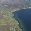
Lonemore lies on the NW coast of Scotland in an area known as Wester Ross. It is centered on NG 78680 77580, and has a southerly aspect overlooking Loch Gairloch. It is one of many crofting townships that form part of the Gairloch estates which come under the lairdship of the Mackenzies. Lonemore lies on the western edge of the village known today as Gairloch, which consists of the three crofting townships of Lonemore, Smithstown and Mihol, and the village of Strath. The three crofting townships share their common grazing which stretches N over the moorland to join up with the common grazing of Naast and Boor townships on the N side of the peninsular.
The Gairloch Estate crofts were made in 1845. The crofts were unusual as they were formed in a grid pattern, so were square instead of the usual rectangular shape. In Lonemore some narrower crofts running down to the sea are rectangular. From estate maps it can be seen that the crofts were an average size of 4.5 to 5.0 acres. The crofts in Gairloch were numbered from Mihol through Smithstown to Lonemore on the W edge, so Lonemore’s crofts run from 33 to 59, making 27 in total.
The township is divided on a W to E axis by the B8021 and on this road Lonemore’s E boundary is the stream known as Caochan an Eorna (Barleyburn) at NG 791774, and the W boundary is the Fasaich cattlegrid at NG 781774. Other access within the township is by a network of minor roads and tracks upgraded from the old crofting passages “pasaidean” which were rights of way, access paths to the crofts.
On Roy’s military map of 1750, the area where Lonemore now stands is called Blarshgan, meaning plain, slender. The name Lonemore first appears on the estate records in 1810 when 14 tenants previously recorded as living in Wester Smithstown in 1806-1809 were then recorded as living in Lonemore. From the Ordnance Survey name books of 1871 to 1877 Lonemore was described as ‘a District in Strath Gairloch comprising dwelling houses and arable land attached. Bordered on the west by Garadh an Fhasaich And of the east by Caochan an Eorna. The property of Sir Kenneth MacKenzie Baronet’
The census shows that in:
1851 there were 124 (including 47 children) recorded names
1861 there were 141 (including 48 children) “
1871 there were 151 (including 45 children) “
1881 there were 116 (including 33 children) “
1891 there were 104 (including 28 children) “
1901 there were 98 (including 28 children) “
Today in 2009 there are approximately 80 adults and 20 children living in Lonemore. There are 51 houses, including one under construction, with 42 of these being permanently occupied.
To the N of the township there are the remains of extensive peat cuts from which peat (used for fuel) for much of the Gairloch area was cut. A special track which still exists was made during the First World War to help take the peat out.
Lonemore was also known for its bog iron and much of the water in the upper burns and pools is still red-brown. Deposits of bog iron or ‘pans’ as reported by Dixon in his book Gairloch and Guide to Loch Maree (1886) were found in broken-up form at the NW end of Lonemore, with lumps of bog iron to be seen in drystane dykes. Recently a 4cm diameter ball of bog iron was found on croft 53.
A detailed field survey of Lonemore Township has shown evidence of settlement from round houses, through pre-crofting and cottars houses, croft houses (some modernised and still lived in) to modern buildings as well as other features such as wells, a possible old school, byres, a stone henhouse, enclosures, causeways across the bog, numerous drystane dykes, and an old clapper bridge.
The results of the survey are detailed on the individual croft plans with additional descriptions of the ruins. The plans are derived from a base plan of the modern OS map with the field survey results added. The scale drawings and descriptions of the ruins are the result of field sketches/measurements.
The social history of Lonemore is detailed in a booklet attached with this site entry which provides the background to the survey results, giving a more complete picture of the history and development of Lonemore Crofting Township. It is the result of research into the Gairloch Estate records, the Census records from 1841 to 1901, books, articles and newspaper reports, photographs and oral evidence from local inhabitants. Information from SRP Lonemore, December 2010.
Organisation SRP Lonemore

