
Berneray, Ruisgarry, Cill Aiseam


Burial Ground (Period Unassigned), Chapel (Period Unassigned)
Site Name Berneray, Ruisgarry, Cill Aiseam
Classification Burial Ground (Period Unassigned), Chapel (Period Unassigned)
Alternative Name(s) St Anselm's Chapel
Canmore ID 10494
Site Number NF98SW 4
NGR NF 9282 8263
Datum OSGB36 - NGR
Permalink http://canmore.org.uk/site/10494


- Council Western Isles
- Parish Harris
- Former Region Western Isles Islands Area
- Former District Western Isles
- Former County Inverness-shire
Field Visit (20 June 1965)
No traces of the Chapel exist, and no local information concerning the site was obtained.
Visited by OS (R D) 20 June 1965.
Reference (2001)
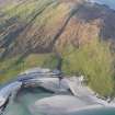
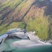
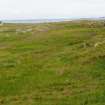
The island of Berneray lies on the SW of the Sound of Harris, only 0.6km from the N shore of North Uist, but is linked administratively to Harris. It measures 5km from E to W by 4km, and a series of low hills in the E part rise to a summit of 93m at the N. The W half of the island is low-lying and covered in sand-dunes and blown sand, although it has produced evidence of prehistoric occupation at Maol Bhan (NF 9090 8278) (1). Population is now confined to the E coast and the valley lying SW of Borve Hill. There is a possible early ecclesiastical enclosure at Cladh Maolrithe (NF 9121 8068), whose name suggests a dedication to St Maelrubha (2), and Martin described two chapels dedicated to St Asaph and St Columba (3). The former is identified with Cill Aiseam, which is represented by a grassy area on the SW side of a small valley, 0.6km from the E shore and 350m NW of Besdarra croft-house. It forms a platform about 25m across which rises about 2m above surrounding marshy ground to W and N. There are no visible gravemarkers or structures except for a damaged turf mound in the NW part, and the area was cultivated during the 19th century, when human remains were found (4).
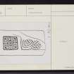
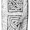
Martin recorded that a stone erected near St Asaph's Chapel was 2.4m high and 0.6m thick (5). This probably refers to the 'obelisk' that was broken about 1820 and subsequently used for window-lintels in two croft-houses. The lower half was returned to the burial-ground, and subsequently lost, but the upper part was obtained by Alexander Carmichael and donated to the National Museum of Antiquities of Scotland in 1870 (NMS X.IB 37) (6). It is of gneiss and measures 1.05m by 0.52m and 80mm thick. Within a flat margin, 0.16m wide at the top and 0.09m to 0.13m at the sides, there is in low relief a square of key-pattern incorporating a central saltire (RA no.995). This is separated by a plain 70mm band from a rectangular panel of double-beaded interlace, broken at the foot and flaked at the right. At the top of the panel there are three parallel strands, but the outer one returns at the left and splits to enter the interlace. At the lower left there is a curve which appears to be the upper armpit of a cross, but it is not apparent whether its arms projected from the slab.
Footnotes:
(1) RCAHMS 1928, No.150; NMRS database NF98SW11.
(2) RCAHMS 1928, No.133; NMRS database NF98SW 8; Name Book, Inverness-shire (Hebrides), No.5, p.240.
(3) M Martin 1934, 47.
(4) A Carmichael 1871, 280-2, referring to remains of a possible dun.
(5) Loc.cit.
(6) Carmichael, loc.cit., recording that within living memory pilgrims' offerings had been made at the foot of the 'obelisk'.
A Carmichael 1871, 280-2; NMAS Cat., 260; Allen and Anderson 1903, 3, 113; RCAHMS 1928, No.115.
I Fisher 2001, 112-13.
Desk Based Assessment
NF98SW 4 9282 8263.
(NF 9282 8263) Site of Cill Aiseam (NR) Graveyard (NAT)
OS 6"map, Inverness-shire, 2nd ed., (1904)
Martin mentions two chapels in Berneray, St Asaph's (Cill Aiseam) and St Columbus'. He also refers to a stone erected near the former, 8ft high and 2ft thick. All traces of the chapel had disappeared by 1870, and the stone was broken into two parts c.1820, the pieces utilised as door-lintels. Carmichael was successful in tracing the upper half and getting it removed. It is a piece of carved gneiss 3ft 8ins x 1ft 7ins x 3ins, and is now in the National Museum of Antiquities of Scotland (NMAS).
The second half has been lost. It was said that the base of the obelisk was surrounded by a heap of pebbles, old coins, bone pins, and bronze needles - all offerings at the shrine of St Asaph. Cultivation on the site has also yielded up a number of bones.
Information from OS.
M Martin 1934; A A Carmichael 1871; RCAHMS 1928; J R Allen 1903.

