
Dulnain Bridge


Railway Bridge (19th Century)
Site Name Dulnain Bridge
Classification Railway Bridge (19th Century)
Alternative Name(s) River Dulnain, Railway Bridge; Broomhill; Ballintomb
Canmore ID 103513
Site Number NJ02SW 12
NGR NJ 0025 2422
Datum OSGB36 - NGR
Permalink http://canmore.org.uk/site/103513

- Council Highland
- Parish Cromdale, Inverallan And Advie
- Former Region Highland
- Former District Badenoch And Strathspey
- Former County Morayshire
NJ02SW 12 NJ 0025 2422.
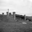
This bridge was designed by Joseph Mitchell to carry the Inverness and Perth Junction Rly across the River Dulnain and opened on 9 September 1863; it remains in use.
M Smith 1994.
This bridge formerly spanned the River Dulnain at a point where it forms the boundary of the parish of Cromdale, Inverallan and Advie with that of Duthil and Rothiemurches. It is depicted as demolished in a line of 'Dismantled Railway' on the OS 1:10,000 map of 1976.
Information from RCAHMS (RJCM), 14 June 1996.
Bridge also lies with parish of Abernethy and Kincardine.
Desk Based Assessment (1 June 2015 - 1 September 2016)
Cultural Heritage assessment for a proposed extension to the Strathspey Railway. The assessment identifies all historic environment features within the development area through desk-based assessment and field survey. An assessment of the direct and indirect impacts of the development on these features is included.
Information from OASIS ID: cfaarcha1-277632.

