
North Uist, Vallaquie, Druim Na H-uamha


Midden (Period Unassigned), Souterrain (Prehistoric), Pin (Bronze)(Prehistoric), Unidentified Pottery (Iron Age)
Site Name North Uist, Vallaquie, Druim Na H-uamha
Classification Midden (Period Unassigned), Souterrain (Prehistoric), Pin (Bronze)(Prehistoric), Unidentified Pottery (Iron Age)
Canmore ID 10305
Site Number NF87NE 2
NGR NF 8645 7545
Datum OSGB36 - NGR
Permalink http://canmore.org.uk/site/10305


- Council Western Isles
- Parish North Uist
- Former Region Western Isles Islands Area
- Former District Western Isles
- Former County Inverness-shire
NF87NE 2 8646 7545.
(NF 8645 7546) Erd House (NR)
OS 6"map, Inverness-shire, 2nd ed., (1904)
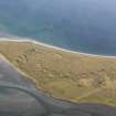
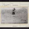
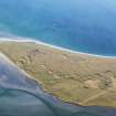
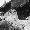
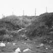
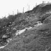
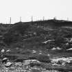
Earth-house, Druim na h-Uamha. The RCAHMS state that the site of this earth-house is to be recognised by a sandy hollow in the surface of a mound amid kitchen refuse.
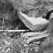
The structure was discovered during ploughing, c. 1861, by the displacement of a roof lintel-slab at a depth of 3ft. Excavation by Carmichael in April 1871 showed it to have been a curved gallery of regular outline 20ft long in an arc of about 50 degres, with vertical parallel walls 5ft 8ins apart and 5ft high. The west end stood at right angles to the side walls but the east end termin- ated in an angular curve. Although robbed of many of its lintel-slabs between 1861 and 1871 one remained in the centre of the gallery and another spanned the walls 4 1/4ft to the west. From this slab to the west end wall the gallery was covered by a domed roof rising to a height of 7 ft from the floor and 4 ft 8 ins wide inside....The apex of this roof was 3ft below ground level.
The gallery was entered in the centre of its south wall by a doorway 2ft 10ins wide at floor level tapering to 2ft 2ins at a height of 2ft 10ins. It was blocked by sand and stones 2 1/2ft beyond its threshold. Above this doorway was a recess or cupboard 1ft 10ins wide and deep and 1ft high. In the north wall were similar recesses.
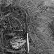
Opposite the entrance in the middle of the gallery a midden was found containing bones of deer and domestic animals, shells, pottery and the upper half of a small quern.
RCAHMS 1928; A A Carmichael 1874.
As described by the RCAHMS. The exact position of this earth-house was pointed out by Mr J Macdonald (Mr Macdonald, Vallaquie, North Uist) at NF 8646 7545.
Site surveyed at 1/2500.
Visited by OS (N K B) 22 June 1965.
Vallaquie (NF 863754) is listed among a number of sand dune sites in North Uist from which sherds of pottery (classified as iron age in 1979) were donated to National Museum of Antiquities of Scotland (NMAS) by Miss M Harman.
Proc Soc Antiq Scot 1978; Proc Soc Antiq Scot 1979.
Field Visit (12 August 1914)
Earth-house, Druim na h-Uamha.
The site of this earth-house, which lies about 300 yards west of Vallaquie at a place known as Druim na h-Uamha ("ridge of the cave"), is now recognised by a sandy hollow in the surface of a mound with some kitchen midden refuse scattered about. When excavated in 1871 it was found to be a curved gallery of regular outline, measuring 20 feet in length, from 5 feet 8 inches at the floor to 4 feet 8 inches at the roof in breadth, and reaching a maximum height of 7 feet. The entrance passage was from the south, and entered the gallery near the centre of its southern wall through a doorway 2 feet10 inches high and from 2 feet 10 inches at the bottom to 2 feet 2 inches at the top in width.
See Anthropological Journal, 1872, p. 272.
RCAHMS 1928, visited 12 August 1914.
North Uist xxxi.
Project (8 May 2007 - 16 May 2007)
NF 8907 7735 (Newton House), NF 8627 7532 (Cnoc a’ Chaisteal), NF 8646 7545 (Druim na h-Uamha)
A souterrain at Newton House was discovered when a tractor partially collapsed the roof. This sparked community interest in the monument type and local residents were interested in two further possible
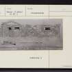
souterrains at Vallaquie. Orkney College Geophysics Unit was subsequently commissioned to survey this group of monuments by the North Uist Access Archaeology Group, in order to better understand the context within which the monuments were situated and define any associated settlement. A combination of gradiometry, resistance survey and ground-penetrating radar (GPR) survey was undertaken from 8–16 May 2007.
The site at Druim na h-Uamha is considerably more complicated than suggested by earlier investigations. The structure excavated and recorded by Carmichael does not appear to be a souterrain and was not clearly visible in the geophysical survey data, although this is likely to be a result of the geophysical properties of excavated features. There is, however, clear evidence for a concentration of structures, including at least one probable souterrain similar to those at Newton House and Cnoc a’Chaisteal, with a possible second, presumably earlier, one alongside. Although the relationships and dating between the structures and the probable souterrains is impossible to interpret without further investigation, the sizeable nature of some of the apparent masonry is suggestive of broch-like architecture. It would also appear that the structures extend beyond the mound to the W and are quite deeply buried in places. The exact nature of this concentration of possible enclosures, pits, walls, and platforms or rubble is unclear but the lack of considerable magnetic enhancement differentiates them from the settlement associated with the mound.
Archive deposited with Geophysics Unit, Orkney College.
Funder: Access Archaeology.
Resistivity (8 May 2007 - 16 May 2007)
NF 8907 7735 (Newton House), NF 8627 7532 (Cnoc a’ Chaisteal), NF 8646 7545 (Druim na h-Uamha)
Orkney College Geophysics Unit undertook a resistivity survey at Vallaquie.
Funder: Access Archaeology.
Magnetometry (8 May 2007 - 16 May 2007)
NF 8907 7735 (Newton House), NF 8627 7532 (Cnoc a’ Chaisteal), NF 8646 7545 (Druim na h-Uamha)
Orkney College Geophysics Unit undertook a gradiometry survey at Vallaquie.
Funder: Access Archaeology.
Ground Penetrating Radar (8 May 2007 - 16 May 2007)
NF 8907 7735 (Newton House), NF 8627 7532 (Cnoc a’ Chaisteal), NF 8646 7545 (Druim na h-Uamha)
Orkney College Geophysics Unit undertook a ground penetrating radar survey at Vallaquie.
Funder: Access Archaeology.

