
North Uist, Vallaquie, An Caisteal


Bank (Earthwork)(S) (Period Unassigned), Clearance Cairn(S) (Period Unassigned)
Site Name North Uist, Vallaquie, An Caisteal
Classification Bank (Earthwork)(S) (Period Unassigned), Clearance Cairn(S) (Period Unassigned)
Alternative Name(s) Nf87ne 15
Canmore ID 10296
Site Number NF87NE 11
NGR NF 8617 7542
Datum OSGB36 - NGR
Permalink http://canmore.org.uk/site/10296


- Council Western Isles
- Parish North Uist
- Former Region Western Isles Islands Area
- Former District Western Isles
- Former County Inverness-shire
NF87NE 11 8617 7542.
(NF 8617 7542) Castle (NR) (Site of)
OS 6"map, Inverness-shire, 2nd ed., (1904)
The site marked by the OS, 200 yards to the west of An Caisteal, Valliquie, 'is evidently in error as it shows no sign of former occupation, consisting merely of rock covered by a scanty growth of turf'.
E Beveridge 1911.
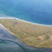
There are no traces of any certain structures visible in this area of amorphous mounds and grass-covered banks. A few circular features can be traced: some of them appear as grass-covered, stony banks but they are either old field walls, stone clearance heaps, or the remains of small structures. The area around the site has been extensively cultivated. Visited by OS (R B) 30 June 1965.
Field Visit (12 August 1914)
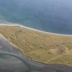
Dun, Vallaquie.
On a mound known as Cnoc a' Chaisteil, a few yards from the seashore about 500 yards west of Vallaquie farmhouse, is the site of a dun, An Caisteal. Some kitchen-midden refuse and shards of pottery were noticed in rabbits' burrows.
RCAHMS 1928, visited 12 August 1914.
OS map: North Uist xxxi (Castle, site of).

