
Juniata: Point Of Grimsetter, Inganess Bay, Orkney, North Sea


Tanker (20th Century)
Site Name Juniata: Point Of Grimsetter, Inganess Bay, Orkney, North Sea
Classification Tanker (20th Century)
Alternative Name(s) Shapinsay Sound; Nana; Sprocol; Juanita:
Canmore ID 102376
Site Number HY40NE 8008
NGR HY 47590 08871
Datum WGS84 - Lat/Long
Permalink http://canmore.org.uk/site/102376


- Council Orkney Islands
- Parish Maritime - Orkney
- Former Region Orkney Islands Area
- Former District Maritime
- Former County Not Applicable
NLO: Inganess Bay [name centred HY 487 102]
Shapinsay [name centred HY 52 19]
Shapinsay Sound [name centred HY 517 133]
Point of Grimsetter [name: HY 481 089].
Formerly entered as Site no. 8921.
See also ND49NE 8048.
Quality of fix = E
Horizontal Datum = OGB
General water depth = 2
Circumstances of Loss Details
-----------------------------
The tanker NANA was sunk as blockship at 58 50 29N, 002 53 59W approximately on 2 March 1939. The bow was refloated and towed to its present position by Metal Industries.
Surveying Details
-----------------------------
29 September 1977. The wreck is shown on aerial photography flown 21 June 1975. The site is described as the forward section of a tanker, some 61 metres long. The vessel was sunk early in World War II at 58 50 30N, 002 54 00W. It was refloated and towed to its present position at 58 57 51.2N, 002 54 40.5W. The stern section is missing. The structure is badly corroded, and there are no plans to salvage.
Report by Orkney Islands Council, 6 September 1977.
Note by wrecks officer: this is most probably part of the NANA. See the wreck at 58 50 29.1N, 002 53 59.4W.
Hydrographic Office, 1995.
Reference (19 April 2012)
UKHO Identifier : 001287
Feature Class : Wreck
Wreck Category : Wreck showing any portion of hull or superstructure
State : LIVE
Classification : Unclassified
Position (Lat/long) : 58.96380,-2.91300
Horizontal Datum : ETRS 1989
WGS84 Position (Lat/long) : 58.96380,-2.91300
WGS84 Origin : Original
Previous Position : 58.96378,-2.91287
Position Method : Differential Global Positioning System
Position Quality : Surveyed
Position Accuracy : 3.0
Depth Quality : Depth unknown
Water Depth : 2
Vertical Datum : Mean Low Water Springs
Name : JUNIATA (FORE PART)
Type : M TANKER
Flag : BRITISH
Length : 64.0
Beam : 10.6
Draught : 5.0
Sonar Length : 56.0
Orientation : 37.0
Tonnage : 1137
Tonnage Type : Gross
Cargo : BALLAST
Date Sunk : 02/03/1939
Bottom Texture : Sand
Sonar Signal Strength : Strong
Contact Description : Partial wreck
Original Sensor : Reported Sinking
Last Sensor : Acoustic Sensor
Original Detection Year : 1939
Last Detection Year : 2010
Original Source : Other
Last Source : Survey Vessel
Reference (March 2012)
Sitename : Nana: Point of Grimsetter, Inganess Bay, Orkney, North Sea
Altname : MV Juniata (fore Part) [+1939]
RFA Sprucol
Note : Kevin Heath (pers. comm) MV Juniata (UKHO Wreck No 1287) originally a blockship at Water Sound.
Sources :
SeaZone Hydrospatial OSGB36 Wrecks point,SeaZone,2010
2010-27833_KirkwallBay_2m_Shoal_WGS84.bag in WGS1984 by Fathoms Ltd on behalf or Orkney Islands Council,UKHO,2009-2010
UKHO wreck report,2012,1287
Note (November 2017)
Mistaken identity and split personality
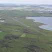
Inganess Bay lies just to the north of Kirkwall airport on the Orkney Islands. A small sandy beach at its south west corner is known as the Sand of Wideford and is a popular place for dog walkers willing to brace the Orcadian wind. Just 130m or so offshore are the remains of a shipwreck with a confusing and complicated story.
The wreck is the bow section of an oil tanker and her story provides a good example of the richness of maritime history and the difficulties in identifying and studying shipwrecks. She is described in websites, books and forums with at least four alternatives being offered as to her identity.
Orkney is unusual in that many of the shipwrecks found in her waters were brought to the island to act as defences against the movement of German U-boats, and to prevent attacks such as the tragic sinking of HMS Royal Oak. The sheltered waters of Scapa Flow provided an ideal deep-water anchorage but the various shallow sounds and deeper channels offered access for enemy as well as allied vessels. One answer to this was the use of blockships, old and worn ships that could be intentionally sunk to provide an obstacle for shipping; another was the construction of physical barriers linking the islands across the shallower sounds.
Many of the blockships that were used had a long history of service, and some had already been renamed once or twice through changing ownership. As they were towed into position some broke up, or were moved over the course of the two World Wars. In later years, some were refloated to be taken away and scrapped, although there are often some archaeological remains left.
The Juniata
This particular wreck was tentatively identified by the Hydrographic Office as the bow section of the Nana (sometimes referred to as the Naja or Majda), a blockship that had been sunk in 1939 within Water Sound and towed to Inganess Bay for scrapping after the war. An alternative explanation was offered in a guide to Scottish shipwrecks in 2003. Here the wreck was confidently described as the bow section of the Vardefjell, a Norwegian tanker that broke apart in heavy seas in 1942. Some local authorities were sure the wreck was in fact the Loch Maddy, a steamship that had been torpedoed near Orkney and towed to Inganess Bay for salvage.
The most plausible explanation (supported by pictorial evidence) is that the wreck is in fact the bow section of the Junaita (sometimes referred to as Juanita), and is only missing a short section of the stern. She was one of the Admiralty designed 1,000 ton oil tankers, and was built at Short Bros. shipyard in Sunderland, launching in January 1918 with the original name Sprocol. Just a few months later she was torpedoed and severely damaged by a German submarine but managed to limp back to Hull, where she underwent repairs for four months. In March 1920 the rebuilt tanker was sold to the Anglo American Oil Company and renamed Juniata serving as an oil tanker for nearly 20 years.
Presumably sold by the oil company, the Juniata was sunk as a blockship in Water Sound on 17 April 1940, in a position almost adjacent to the Naja mentioned above. In July 1949 the Juniata was raised for scrapping and towed north around the coastline of Orkney. En route it was found that she was in such poor condition that she would have to be towed ashore and she was beached at Inganess Bay.
Shipwrecks, even those of a relatively recent age, give a fresh perspective on the past. Their mobility makes them a physical expression of the cultural connectedness so often studied by archaeologists: a ship like Juniata will no doubt have travelled all over the world during her 22 year working life. They also present a specific challenge to researchers and heritage managers. The Juniata has two records in Canmore, one reflecting her original position as a blockship, were parts of her hull may remain, the other her ‘new’ position on Inganess beach. The perfectly understandable confusion over her identity is simply a product of the number and density of shipwrecks in Orkney’s waters, and can often only be resolved by the recovery of a ship’s bell, or the careful study of historic photographs.
Author: George Geddes, Archaeologist, Survey and Recording

