
Inverlane: Burra Sound, Scapa Flow, Orkney


Motor Tanker (20th Century), Steamship (20th Century)
Site Name Inverlane: Burra Sound, Scapa Flow, Orkney
Classification Motor Tanker (20th Century), Steamship (20th Century)
Alternative Name(s) Inverlane (Bow Section)
Canmore ID 102320
Site Number HY20NW 8003
NGR HY 2459 0509
Datum WGS84 - Lat/Long
Permalink http://canmore.org.uk/site/102320


- Council Orkney Islands
- Parish Maritime - Orkney
- Former Region Orkney Islands Area
- Former District Maritime
- Former County Not Applicable
HY20NW 8003 2454 0513
N58 55.6333 W3 18.65
NLO: Graemsay [name: HY 270 053]
Hoy Sound [name centred HY 236 072]
Stromness [name: HY 253 090]
Scapa Flow [name centred HY 36 00].
Formerly entered as HY20NW 8861.
For other wrecks in this group, see HY20NW 8001-2, HY20NW 8004-6 and HY20SW 8001-2.
For plan indicating the relative locations and orientations of blockships in this group, see Macdonald 1990, 108.
For the stern portion of this vessel (NMRC NZ46SW 14), still in English waters, see NMRS MS/829/53.
Quality of fix = PHOT
Horizontal Datum = OGB
Buoyage =
General water depth = 8
Orientation of keel/wreck = 045225
Circumstances of Loss Details
-----------------------------
The motor tanker INVERLANE was mined on 14 December 1939 off South Shields. The bow section was used as a blockship in Burra Sound.
Surveying Details
-----------------------------
15 October 1975. This particular wreck dries to reveal approximately 15.2 metres at the bows. It is the wreck of a tanker, of which only the bows and midships section remain. The name can just be made out on bows to be the INVERLANE. An estimate of its size would be about 16,000 tons.
Report by CPO Dunford, RAF Lincoln, 15 August 1975.
13 August 1976. The above report is confirmed. The wreck lies on an orientation of 094/274 degrees and is approximately 300 feet (91.4 metres) long.
Report by Dept of Harbours, Kirkwall, Orkney, 5 July 1976.
21 July 1988. The wreck's position is approximately 58 55 38N, 003 18 39W. The length is about 70 metres (229 feet). The keel is orientated 045/225 degrees approximately. The foremast is still standing. The bow stands about 12 metres above low water [lat], and the mast is approximatley 5 metres higher.
Source; aerial photography, dtd 6 June 1975.
Note: The tidal state was apparently approximately 0.6 metres above chart datum or lowest astronomical tide.
Hydrographic Office, 1995.
(Classified as motor tanker: date of loss cited as 30 May 1944). Inverlane: the bows and mifdships portions only of this vessel were sunk as a blockship in Burra Sound.
Registration: Dublin. Built 1937. 9141grt. Length: 145m. Beam: 19m.
(Location of loss cited as N58 55.55 W3 18.68).
I G Whittaker 1998.
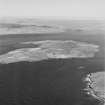
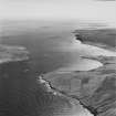
Photographed from the air by RCAHMS, 1997.
(Undated) information in NMRS.
The Blockships of Burra. The INVERLANE has been punished over several decide with the tidal currents. Marine corrosion has also played a part. Finning through the INVERLANE's many corridors the pipework is encrusted with with orange anenomes. The occasional rope lay on the sand covered deck. There are numerous open hatches and doorway letting in daylight and alowing easy escape if necessary. Outside the ship kelp anchored to the hull is caught in the strong currents. The tide also flushes the area clear of silt. Back on deck tufts of grass grow in the corners and there is a tremendous stench of bird droppings from the birds colonising the superstructure.
Source: Diver Magazine [unstated year], 27-8.
Length: 145m
Beam: 19m
GRT: 9141 [also cited as 8900]
The prominent bow and mast of the projecting bow and midships portion of this steam tanker [not motor tanker as previously entered] make this a prominent feature and the only member of the Burra Sound group to remain visible above the surface. She remains a popular diving wreck, as does the after portion of the wreck. This lies in 10.5m charted depth at N54 56.3 W1 20.9, off Seaburn, Sunderland, NE England (BSAC Wreck Register, East Coast, no. 18 (164), dated 1987).
The vegetable, oil and wine tanker was built by Vegesack at Bremen, Germany in 1938; an oil engine and an unspecified number of boilers (which survive in the English portion) drove a single screw. She was mined off South Shields on 14 December 1939, broke into two portions, and was declared a constructive total loss. The larger (forward) portion was sunk as an additional blockship in Burra Sound in 1944 and was frequently visited by recreational divers until the winter of 1996/7, when much of the structure collapsed. Only the focsle now retains its recognizable shape.
No further details of the service or commercial history of the ship are apparently available and there is no published photograph of the ship in service. The circumstances under which she first passed into British mercantile service and was sunk as a blockship (later than the others and after the construction of the Churchill Barriers) are not recorded in the available literature.
Burra Sound forms a narrow gap between Hoy Skerries (to the SW) and the island of Graemsay. Several wrecks are charted in a general depth of between 5 and 12m; the sound is subject to pronounced tidal flows.
Information from RCAHMS (RJCM), 1 October 2002.
BSAC Wreck Register 1987; R and B Larn 1998; R Macdonald 1998; I G Whittaker 1998.
UKHO chart 35 (1991).
(Selected) vertical air photography: CPE/SCOT/UK 185 2435-6, flown 9 October 1946, and Fairey Coastal Colour (FCC) 7343 43 369-70, flown 6 June 1975.
Information from RCAHMS (KM, RJCM), 25 October 2002.
This 9000 ton tanker was launched at Vegesack, Germany in Deember 1938, and mined in 1939. In 1944, her bows and midships portion were sunk in Burra Sound as a blockship, being one of the last vessels to be positioned for this purpose. Her bow and masts were visible above the surface until winter 1996 when part of the hull collpased and much of the wreck disappeared. On 29 January 2000, she sank finally below the surface in a storm.
The remains of this wreck are now completely below the surface, and are understood to be buoyed. Only 'big metal plates' are said to survive.
Information from Mr R Forbes (Stromness), 25 October 2004.
Desk Based Assessment (August 1997)
Throughout the two World Wars Scapa Flow served as the base of the British Home Fleet. Access to these waters was guarded by a series of coastal batteries, booms and blockships. The blockships comprised old and damaged vessels which were deliberately sunk in position so as to form a submarine obstacle to deter enemy incursions. After 1945 some of the blockships were dispersed by explosives to clear the shipping lanes while many others were salvaged for parts and metal. The wrecks of several blockships remain on the sea bed and in the intertidal zone.
(i) [HY20SW 8002] The Gobernador Bories, a 2,332 ton iron steamer, was built in 1882 at West Hartlepool. She was sunk in Burra Sound in 1915. She lies S of Hoy Skerries and is relatively intact.
(ii) [HY20SW 8001] The Ronda was built in 1889 in Sunderland and was sunk in 1914. She was a steel single-screw 1,941 ton steamer. She was dispersed with explosives in 1962.
(iii) [HY20NW 8005] Built in Glasgow in 1882, the 2,252 steel single-screw steamer, Budrie, was sunk in 1915. She was dispersed with explosives in 1962.
(iv) [HY20NW 8003] The Rotherfield was a 2,831 ton steel single-screw steamer. Built in West Hartlepool in 1889, she was sunk in Burra Sound in 1914. She was dispersed with explosives in 1962.
(v) [HY20NW 8004] A 3,423 ton steel single-screw steamer, the Urmstone Grange, was built in Belfast in 1894 and was sunk in 1914. She was dispersed with explosives in 1962.
(vi) [HY20NW 8003] Built in 1938 in Germany, the 8,900 ton tanker Inverlane was holed by a mine off South Shields in 1939. She was patched up, towed to Burra Sound and, there, sunk as a blockship in 1944. She remains relatively intact and her bows are clearly visible, rising from the waters to the S of Hoy Skerries.
(vii) [HY20NW 8006] The Tarbraka was a single-screw steamer of 2,624 tons. Built in Rotterdam in 1909, she was captured by the Royal Navy in 1940 and was sunk as a blockship, initially in Kirk Sound. At the completion of Churchill Barrier 1, the Tarbraka was re-floated and sunk in Burra Sound in 1944. She now lies, upside down, in 12m of water to the S of Hoy Skerries.
(viii) [HY20SW 8001] The 1,761 ton single-screw steamer the Doyle, built in Troon in 1907, was sunk in 1940. She lies relatively intact beneath 15m of water.
Multi Beam Sonar Scan (6 December 2011 - 10 December 2011)
The multibeam sonar data records broken up remains, likely from the wrecks of the Inverlane and Budrie, over an area of seabed of around 4000 sq. m within Burra Sound, at depths ranging from 6.7m to 11.3m below chart datum. Both wreck sites appear dispersed and overlapping and cannot be separated in the data with certainty. However, the following interpretation may be supported by assertions by Wood (2008: 140) that the Inverlane sank directly over the Budrie and that some of the Inverlane’s hull plates cover the lower vessel.
UTM 30 N (WGS 84) X: 482009.1 Y: 6531938. A substantial section of plating lies at an orientation of 41 degrees, and measures 59.8m long, 19.8m wide and 6.9m high. This may be from the top deck of a vessel, possibly the Inverlane, and may overlie remains of the Budrie.
UTM 30 N (WGS 84) X: 482034.8 Y: 6531931 A dispersed section of wreckage covering an area measuring 51m by 16.1m with a maximum height above the seabed of 1.9m, believed to be the remains of Budrie. The largest part of this wreckage, possibly part of the deck, is partially overlain by a curved section of wreck which may be part of the hull of a vessel (possibly the Inverlane). The underlying part is flat and may the remains of a vessel deck. A rectangular feature measuring 2.8m by 5.9m at the southern end of this structure may be the remains of a deck house.
UTM 30 N (WGS 84) X: 482067.1 Y: 6531911 - is the bow or stern of one of the Budrie or Inverlane and measures 25.6m long and 17.1m wide. Although most of the deck and hull plating are missing the shape of the structure is still discernible from the ribs and this section appears to be lying on its keel. A bulkhead can be seen across the south west end of this section of wreck with a square feature running up it and measuring 1.3m by 1.5m across. A boiler rests against the north side of 7016 which is 4.3m across and 3.7m long,
Information from Wessex Archaeology April 2012.
Reference (2011)
Whittaker ID : 1150
Name : INVERLANE
Latitude : 585533
Longitude : 31841
Date Built : 1937
Registration : DUBLIN
Type : MOTOR TANKER
Tonnage : 9141
Tonnage Code : G
Length : 145
Beam : 19
Draught : 11m
Position : Exact Position
Loss Day : 30
Loss Month : 5
Loss Year : 1944
Comment : Bows and midships only used as blockship in Burra Snd
Project (April 2012)
Excerpt from the report:
'SCAPA FLOW WRECK SURVEYS
Archaeological Interpretation of Multibeam data and Desk-Based Assessment
WA Ref: 83680.03
Summary:
WA Coastal and Marine was commissioned by Historic Scotland to provide highresolution multibeam bathymetry data targeted on a number of wreck sites in Scapa Flow in the Orkney Islands. The list of targets were provided by Historic Scotland, ordered by priority, based on the importance of the wreck and the lack of prior survey at each site. Scapa Flow is a large natural harbour in the southern part of the Orkney Islands in
the North of Scotland, which served as Britain’s main naval base during WWI and WWII. Its waters hold Scotland’s highest concentrations of shipwrecks. Although some of the wrecks in Scapa Flow have previously been the subject of highresolution multibeam surveys there remain a number of important sites which had only previously been covered by low-resolution data acquisition or not covered at all.
WA Coastal & Marine conducted an archaeological assessment of the multibeam data and a Desk-Based Assessment (DBA) of the wreck sites it covered in order to enhance the historic environment record with respect to these sites and to support Historic Scotland’s work on the Scottish Marine Protected Areas Project. Through a thorough review of published and online material relating to the wrecks thought to be in the vicinity of Scapa Flow it has been possible to produce a detailed discussion of these sites in almost every case and also to clarify a number of conflicting sources. This has enabled us to state with certainty the exact location of
each targeted wreck from the multibeam survey, in some cases for the first time. In addition a thorough review of published material and diver accounts has enabled an informed analysis of features visible at each wreck site. The importance of these wreck sites can now be placed within their national and, in some cases, internationalcontexts.
A total of 18 wrecks were surveyed and assessed over the course this project. 16 of have been identified. The two remaining unidentified wrecks are both located in Burra Sound and are isolated pieces of wreck material, which may be associated with recorded losses in the area. The positions of all 16 identified wrecks have been improved, in some cases by over 100 metres. The survey has also greatly aided in understanding the relative positions of the wrecks to each other. The project has also highlighted discrepancies between some diver reports and observed details in the survey data, such as the structural details of some wrecks.'
Information also reported in Oasis (waherita1-136288) 18 June 2013
Reference (19 April 2012)
UKHO Identifier : 001096
Feature Class : Wreck
Wreck Category : Dangerous wreck
State : LIVE
Classification : Unclassified
Position (Lat/long) : 58.92609,-3.31305
Horizontal Datum : ETRS 1989
WGS84 Position (Lat/long) : 58.92609,-3.31305
WGS84 Origin : Original
Previous Position : 58.92608,3.31305
Position Method : Differential Global Positioning System
Position Quality : Surveyed
Position Accuracy : 3.0
Depth : 0.9
Depth Method : Found by multi-beam
Depth Quality : Least depth known
Water Depth : 10
Water Level Effect : Always under water/submerged
Vertical Datum : Mean Low Water Springs
Name : INVERLANE (BOW SECTION)
Type : M TANKER
Flag : BRITISH
Sonar Length : 99.0
Sonar Width : 30.0
Shadow Height : 10.0
Orientation : 80.0
Tonnage : 9141
Tonnage Type : Gross
Date Sunk : ??/??/1944
Sonar Signal Strength : Strong
Scour Depth : 0.0
Debris Field : NIL
Contact Description : Partial wreck
Original Sensor : Observed Sinking
Last Sensor : Acoustic Sensor
Original Detection Year : 1944
Last Detection Year : 2010
Reference (March 2012)
Sitename : Inverlane (part of)
Altname : Burra Sound, Scapa Flow, Orkney
Note : MBES geophysical anomaly of blockship remains at N58 55.587 W3 18.68716 of high archaeological potential. An irregular shaped mound on the seabed, measures around 35 metres in diameter and is about 8 metres in height. It is situated in about 8 metres of water on irregular ground. Due to the nature of the supplied MBES survey data it is difficult to ascertain which blockship these remains could be associated with.
According to Kevin Heath this is part of the Inverlane. The rest of the Inverlane is mixed in with the other blockship wreckage to its immediate west.
Sources :
Kevin Heath (personal communication),2012
Burra Sound at 2m resolution in WGS1984 Bathymetry id 2010-27833_ScapaFlowMain_Burra_2m_SB_WGS84.bag

