|
Manuscripts |
MS 1031/4 |
EASE Archaeology (Environment and Archaeology Services Edinburgh) |
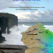
Report on a Coastal Zone Assessment Survey of Orkney: Burray, Flotta, Graemsay, Hoy and South Ronaldsay. |
8/1997 |
Item Level |
|
|
Photographs and Off-line Digital Images |
D 86383 CS |
RCAHMS Aerial Photography |
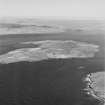
Aerial view of Orkney, Hoy, Burra Sound, taken from the SW, of the former oil tanker, Inverlane, used as a blockship to protect the entrances to Scapa Flow against submarine attack. |
4/6/1997 |
Item Level |
|
|
Photographs and Off-line Digital Images |
D 86384 CS |
RCAHMS Aerial Photography |
Aerial view of Orkney, Hoy, Burra Sound, taken from the SW, of the former oil tanker, Inverlane, used as a blockship to protect the entrances to Scapa Flow against submarine attack. |
4/6/1997 |
Item Level |
|
|
Photographs and Off-line Digital Images |
D 14690 |
RCAHMS Aerial Photography |
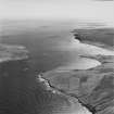
Oblique aerial view of Burra Sound between Hoy and Graemsay, taken from the NW. Visible is the Second World War Skerry Coastal Battery and the blockship, 'Inverlane', formerly a tanker. |
5/8/1997 |
Item Level |
|
|
Photographs and Off-line Digital Images |
D 14691 |
RCAHMS Aerial Photography |
Oblique aerial view of Burra Sound between Hoy and Graemsay, taken from the WNW. Visible is the Second World War Skerry Coastal Battery and the blockship, 'Inverlane', formerly a tanker. |
5/8/1997 |
Item Level |
|
|
Manuscripts |
MS 829/53 |
|
Printout of NMRC record of the Inverlane (in English waters), received September 2002. |
9/2002 |
Item Level |
|
|
Digital Files (Non-image) |
DT 000054 |
Records of the Royal Commission on the Ancient and Historical Monuments of Scotland (RCAHMS), Edinbu |
Whittaker's Off-Scotland Database, |
2011 |
Item Level |
|
 |
Digital Files (Non-image) |
WP 000538 |
Wessex Archaeology |
Report: Scapa Flow Wreck Surveys - Archaeological Interpretation of Multibeam data and Desk-based Assessement |
4/2012 |
Item Level |
|
 |
Digital Files (Non-image) |
WP 000721 |
Orkney Research Centre for Archaeology (ORCA) |
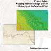
ORCA Marine: Project Adair - Mapping heritage sites in Orkney and the Pentland Firth |
4/2012 |
Item Level |
|
|
Digital Files (Non-image) |
DT 000069 |
Orkney Research Centre for Archaeology (ORCA) |
ORCA Project Adair main database. |
3/2012 |
Item Level |
|
|
Digital Files (Non-image) |
DT 000070 |
Orkney Research Centre for Archaeology (ORCA) |
ORCA Project Adair polygon database. |
3/2012 |
Item Level |
|
|
Digital Files (Non-image) |
TM 000044 |
Orkney Research Centre for Archaeology (ORCA) |
ORCA Project Adair area shapefile. |
3/2012 |
Item Level |
|
|
Digital Files (Non-image) |
TM 000045 |
Orkney Research Centre for Archaeology (ORCA) |
ORCA Adair site area polygons. |
3/2012 |
Item Level |
|
 |
On-line Digital Images |
SC 1682069 |
RCAHMS Aerial Photography |
Oblique aerial view of Burra Sound between Hoy and Graemsay, taken from the NW. Visible is the Second World War Skerry Coastal Battery and the blockship, 'Inverlane', formerly a tanker. |
5/8/1997 |
Item Level |
|
 |
On-line Digital Images |
SC 1682070 |
RCAHMS Aerial Photography |
Oblique aerial view of Burra Sound between Hoy and Graemsay, taken from the WNW. Visible is the Second World War Skerry Coastal Battery and the blockship, 'Inverlane', formerly a tanker. |
5/8/1997 |
Item Level |
|
|
Manuscripts |
MS 5473 |
Historic Scotland Archive Project |
Maritime archive: Magazine report and Correspondence associated with the wrecks of Orkney, including the Inverlane, HMS Royal Oak and the Imperial German High Seas Fleet. |
4/1988 |
Batch Level |
|


