
Kebister


Plough Marks (Period Unassigned), Settlement (Period Unassigned)
Site Name Kebister
Classification Plough Marks (Period Unassigned), Settlement (Period Unassigned)
Alternative Name(s) Dales Voe; Burn Of Kebister
Canmore ID 1018
Site Number HU44NE 5
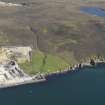
NGR HU 4572 4552
Datum OSGB36 - NGR
Permalink http://canmore.org.uk/site/1018


- Council Shetland Islands
- Parish Tingwall
- Former Region Shetland Islands Area
- Former District Shetland
- Former County Shetland
HU44NE 5.00 4572 4552
HU44NE 5.01 HU 4569 4549 Chapel (possible); Burial-ground
HU44NE 5.02 HU 4570 4550 Barn: Tithe; Corn-drying kiln
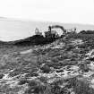
Rescue excavations and survey work were undertaken in advance of the construction of an oil rig supply base.
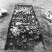
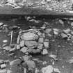
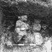
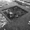
A low, circular mound immediately north of the post-medieval structure (HU44NE 5.02) marked the disturbed top levels of a prehistoric settlement. Finds over the mound surface included coarse pottery, stone and steatite artefacts of probable Norse origin. Beneath the farming disturbance was a damaged oval house site. The external wall was mostly ruinous but it was comparatively intact on the S side. No definite entrance was located. Orthostats punctuated the internal wall face within the building and formed alcoves, at least one of which was recessed into the wall itself. The interior had maximum dimensions of approximately 4m by 3m. Thick black occupation layers and a peat ash hearth filled the centre, and quantities of coarse pottery and stone implements were recovered. A complex series of drainage gullies, some contemporary with the building, ran below the walls and across the interior.
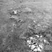
Another structure, comprised almost entirely of features in natural clay, underlay this one. The walls were marked by a double row of deep circular postholes, revealing a circular construction, about 8m in diameter. Many of the postholes were connected to each other by shallow slots and grooves. A substantial, rectangular, central hearth was the primary feature. Finds were scarse, but some coarse pot and stone implements were recovered. Other features were a large, oval water container and a rectangular cooking trough. Evidence of a sandstone knapping industry overlay the primary occupation features of the structure.
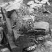
Remains of another building were discovered to the E. The building was in two phases and of a differing character from those above. The original eastern wall consisted of an internal face of coursed dry-stone walling, with a central entrance. Straight sections of simlar walling adjoined either end of the curve and another entrance was located in the southern section of walling. Another curving wall ran parallel to the eastern end, enclosing a yard some 5m wide, where metal working took place. Two levels of rough paving filled the space between the two walls, forming an additional room or recess to the original building. The interior of the structure was filled with thick black occupation layers and a stone built hearth, rebuilt several times, was found. Much coarse pottery and many stone implements were recovered.
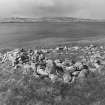
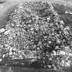
A massive stone built enclosure wall partially encircled the prehistoric settlment. Survey work in the areas revealed traces of multi-period agricultrual activity, including at least three sub-peat dykes.
O Owen and C Lowe 1985.
Sponsor: HB&M, Lerwick Harbour Trust.
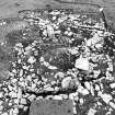
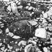
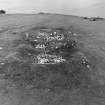
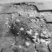
Immediately N of the large house (HU44NE 5.02) a stone built, multi-cullular structure of at least two phases was located. It is likely to date from the late Iron Age on the basis of its pottery and structural type. The major linear cell had a paved floor overlying a clay floor with a hearth. The entrance was probably in the west. As with all areas at Kebister, it was rich in artefactual remains. To the E of this structure there was an area densely packed with complex negative features, pits, troughs, posthole, gullies and drains, often superimposed on each other, and may cutting a thick spread of burning. E of these features, part of a well built stone platform located in the section indicates that there may still be more structures to unearth at Kebister.
Prehistoric cultivation marks were found below all areas excavated in 1986 to the N of the large house.
Three thermoluminescent survey dates for the earliest structure so far excavated have been obtained, and they all suggest that it is Neolithic.
O Owen and C Lowe 1986.
Sponsor: SDD - HBM - CEU
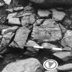
Excavation of the prehistoric site was completed. A 4.60m stretch of walling containing a well-constructed semi-circular alcove is all that remains of a further stone structure. It pre-dates the oval house of stone and turf excavated in 1985. Substantial drains infilled with collapsed building masonry yielded a large quantity of stone artefacts including worked quartz implements, but no pottery. Analogy with the assemblage from the Scord of Brouster suggests a Neolithic date for this phase.
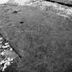
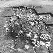
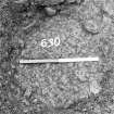
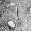
Ard marks were revealed across most of the site, overlying this phase. They criss-crossed each other diagonally, but the predominant trench was NW to SE. No field edges were discerned, but a collection of fine stone ard points was found distributed among the levelled stonework below. There the plough had broken on hitting undertlying stone debris. This is beleived to be the first discovery of ard points in direct association with ard marks.
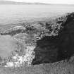
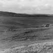
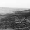
An intensive systematic survey of the hillside above the site was undertaken in order to place the excavate site in its full local and environmental context. It revealed other areas of archaeological interest, notably a cluster of at least 6 burnt mounds about 290m E of the excavation (HU44NE 7), one large burnt mound with a central depression about 75m to the SE (HU44NE 8), another mound with protruding orthostats which is likely to represent a futher prehistoric house site at 120m to the SW (HU44NE 9) and intricate field systems, including sub-peat dykes, over a wide area (HU44NE 10).
O Owen and C Lowe 1987.
Sponsor: HBM: CEU, Shetland Amenity Trust.
One unroofed building is depicted on the 1st edition of the OS 6-inch map (Orkney and Shetland (Shetland) 1881, sheet liii). Two unroofed buildings are shown on the current edition of the OS 1:10000 map (1973).
Information from RCAHMS (AKK) 20 March 2001.
The excavation archive from Kebister has been catalogued. The archive consists of manuscripts, photographic material and drawings. Digital and audio archive is available and consists of drafts of the Kebister 1999 monograph, the stone catalogues, the key for the soil maps, mini data cartridges containing 'Kebister modified files' and a recorded conversation with Mr and Mrs Anderson.
Historic Scotland Archive Project (SW) 2001

