
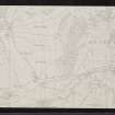
North Uist, Eaval, Loch Dun An T-siamain, Dun An T-siamain


Causeway (Prehistoric), Dun (Prehistoric)
Site Name North Uist, Eaval, Loch Dun An T-siamain, Dun An T-siamain
Classification Causeway (Prehistoric), Dun (Prehistoric)
Canmore ID 10179
Site Number NF85NE 4
NGR NF 88587 59495
Datum OSGB36 - NGR
Permalink http://canmore.org.uk/site/10179


- Council Western Isles
- Parish North Uist
- Former Region Western Isles Islands Area
- Former District Western Isles
- Former County Inverness-shire
Field Visit (14 August 1915)
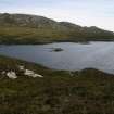
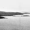
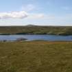
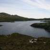
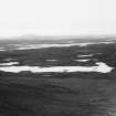
Dun an t-Siamain, Loch Dun ant-Siamain, Eaval.
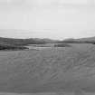
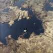
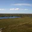
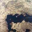
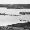
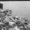
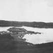
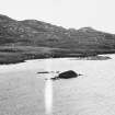
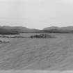
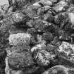
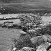
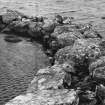
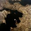
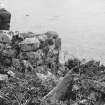
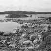
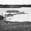
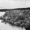
Dun an t-Siamain is an interesting fort and much better preserved than the great majority of the Hebridean duns. It occupies the whole area of a small island about 40 yards from the eastern shore of Loch dunan t-Siamain, a small loch lying at the foot of the south-western slope of Eaval. It is connected with the shore by a causeway lying partly now on dry land, and partly in the water, above which it rises to a height of about 2 feet. This indicates that there has been a considerable fall in the level of the loch. The causeway is well preserved, and seems to have had a general width of 4 to 5 feet, and it measures about 56 yards in length. If follows a very erratic course, for while its general direction is westerly, it curves towards the north for the first 50 feet, then strikes out in a north-westerly direction for some 46 feet, returning in a sickle-like curve to the dun some 73 feet in length. About 12 feet from the island end a modern wall has been built across it. The dun is sub-oval on plan, but facing the east-south-east the wall forms an obtuse angle. Externally it measures 46 feet 6 inches from north-west to south-east, and 42 feet across. The wall of the dun rises directly out of the water, and though a considerable quantity of stones has fallen outside from its summit, it still maintains an average height of some 4 feet, rising to 6 feet at the north; on the western side a short section is broken down and the building is quite hidden by tumbled stones. The interior is completely filled with stones which obscure nearly the whole of the inner face of the wall, but where this is visible, as on the eastern side, the wall measures 5 feet 9 inches in thickness at the top.
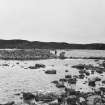
The doorway into the dun, which has penetrated the wall some 6 feet south-east of the end of the causeway, is blocked with stone, but the southern jamb is traceable, and two slabs, one lying inside the passage and another outside, have probably been lintels. In the southern end of the dun a wide, well-preserved opening, a water-gate, measures 7 feet 6 inches in breadth at the outside and narrows very slightly inwards. The wall on the west is 4 feet 8 inches thick and is 6 feet high, and on the east it is 4 feet 4 inches thick. Outside the collapsed portion of the wall to the west is a significant circular flooring of stones on the bed of the loch, extending some16 feet from the wall of the dun. The marginal blocks are carefully placed in a regular curve, but the inner part of this construction, possibly a boat harbour, is covered with tumbled blocks of stone. On the bank of the loch, in a slight hollow some 25 yards east of the land end of the causeway, are the stone foundations of an oval structure, measuring internally 9 feet in length, and 7 feet in breadth.
RCAHMS 1928, visited 14 August 1915.
OS map: North Uist xl.
Field Visit (9 June 1965)
Dun an t-Siamain is generally as described [previously], but is oval in plan, measuring 14.0m N-S by 9.0m E-W with walls 1.3m wide. The walled recess, described as a cattle-shelter by Beveridge, is on the eastern shore of the loch and appears to be a relatively modern shieling. Across the island end of the causeway there is a defensive wall 1.0 m. wide by 1.5m high and 3.0m long.
Surveyed at 1:1250 and 1:10,560.
Visited by OS (R D) 9 June 1965.
Desk Based Assessment (10 March 1965)
NF85NE 4 88587 59495.
(NF 8857 5947) Dun an t-Siamain (NR)
OS 6"map, Inverness-shire, 2nd ed., (1903)
Dun an t-Siamain lies on an island in, and gives its name to, a loch in North Uist.
It is somewhat circular, 44ft N-S by 52ft E-W over walls 52 to 75ins thick. There are signs of a doorway, 33ins wide, slightly south of the island end of a causeway, which zig-zags to the eastern shore of the loch, 25 yards away. There is a boat entrance to the south. Traces of a circular cell, 51ins across, can be seen on the east edge of the island, and remains of another, apparently dome-shaped, with a base diameter of about 4ft, are in the north.
To the north of the shore end of the causeway, there is a walled recess in the bank which probably served as a cattle shelter.
Information from OS (MSG) 10 March 1965
E Beveridge 1911.
Diver Inspection (1 July 2010 - 29 July 2010)
NF 88587 59495
Underwater investigations from 1–29 July 2010 were directed towards examining island duns, crannogs or ‘island dwellings’ on North Uist, Benbecula and several
mainland sites in Sutherland and Argyll. One of the key aims was to assess the artificiality of the islets and to examine the loch bed surrounding the sites for archaeological material or associated features such as causeways and harbours.
Another aim was to confirm or reject unverified sites, i.e. uninspected possible crannogs.
Underwater inspection of Dun an t-Siamain revealed what appears to be an enhanced natural islet beneath the dun. Imported stone lying at the base of the islet probably represents both structural tumble and efforts to enlarge the site. Later prehistoric pottery was found on the loch bed in 2m of water c3m from the site, near what appears to be a rear entrance or boat naust, 180° opposite the causeway. A largely intact vessel (65%) 120 x 120mm was recovered. This
vessel has applied wavy cordon typical of Hebridean pottery and probably relates to occupation phases of the Iron Age Atlantic roundhouse.
Report: RCAHMS (intended)
Funder: The 2010 GAMA Award courtesy of the Gatliff Trust
R Lenfert 2010

