
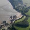
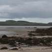
Unknown: Milton Sands, Kirkcudbright Bay, Solway Firth


Craft (Possible)
Site Name Unknown: Milton Sands, Kirkcudbright Bay, Solway Firth
Classification Craft (Possible)
Alternative Name(s) Goat Well Bay; Unknown
Canmore ID 101629
Site Number NX64NE 8027
NGR NX 65905 48355
Datum WGS84 - Lat/Long
Permalink http://canmore.org.uk/site/101629


- Council Dumfries And Galloway
- Parish Maritime - Dumfries And Galloway
- Former Region Dumfries And Galloway
- Former District Maritime
- Former County Not Applicable
NX64NE 8027 6591 4835
N54 48.7167 W4 5.2
NLO: Goat Well Bay [name centred NX 662 481]
Kirkcudbright Bay [name centred NX 655 455]
Milton Sands [name centred NX 658 484].
Formerly entered as NX64NE 8041 and classified as Obstruction.
Horizontal Datum = OGB
Surveying Details
-------------------------
16 September 1959. A site is shown at position 54 48 43N, 004 05 12W on chart 2207.
Hydrographic Office 1995.
Unknown: stranded. [No further information].
(Location cited as N54 48.72 W4 5.20).
I G Whittaker 1998.
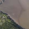
The cited location falls on the W side of Kirkcudbright Bay, within the area of Milton Sands. It is apparently in an intertidal context.
The implicit classification (by Whittaker) of this obstruction as a wreck is accepted.
Information from RCAHMS (RJCM), 14 January 2002.
External Reference (16 September 1959)
Horizontal Datum = OGB
Surveying Details
-------------------------
16 September 1959. A site is shown at position 54 48 43N, 004 05 12W on chart 2207.
Hydrographic Office 1995.
Evidence Of Loss (1998)
Unknown: stranded. [No further information].
(Location cited as N54 48.72 W4 5.20).
I G Whittaker 1998.
Note (14 January 2002)
The cited location falls on the W side of Kirkcudbright Bay, within the area of Milton Sands. It is apparently in an intertidal context.
The implicit classification (by Whittaker) of this obstruction as a wreck is accepted.
Information from RCAHMS (RJCM), 14 January 2002.
Reference (19 April 2012)
UKHO Identifier : 005374
Feature Class : Wreck
Wreck Category : Wreck showing any portion of hull or superstructure
State : LIVE
Classification : Unclassified
Position (Lat/long) : 54.81198,-4.08688
Horizontal Datum : ORDNANCE SURVEY OF GREAT BRITAIN (1936)
WGS84 Position (Lat/long) : 54.81206,-4.08814
WGS84 Origin : 3-D Cartesian Shift (BW)
Previous Position : 54.81195,-4.08667
Position Method : Air photography
Position Quality : Precisely known
Depth Quality : Depth unknown
Water Depth : -3
Vertical Datum : Lowest Astronomical Tide
Name : UNKNOWN
Bottom Texture : Sand
Contact Description : None reported
Original Sensor : None reported
Last Sensor : Video Sensor
Original Detection Year : 1959
Last Detection Year : 1984
Original Source : Survey Vessel
Last Source : Other
Surveying Details : **H5106/59 16.9.59 ST SHOWN IN 544843N, 040512W ON SURVEY [K2207]. NC 1344.
POSITIONS BELOW THIS POINT ARE IN DEGREES, MINUTES AND DECIMALS OF A MINUTE
**28.2.00 SHOWN AS OUTLINE OF WK [STRANDED] IN 5448.719N, 0405.213W [OGB] ON PHOTOPLOT PG 1832/1 [PHOTOS DTD 1984]. CHART AS ST. NE 1344.
Chart Symbol : ST
Date Last Amended : 28/02/2000
Date Position Last Amended : 28/02/2000
Photographic Record (2015)
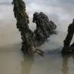
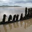
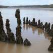
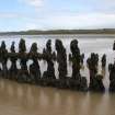
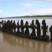
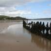
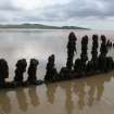
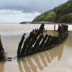
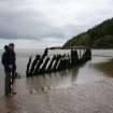
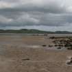
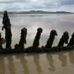
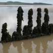
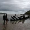
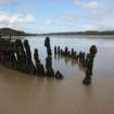
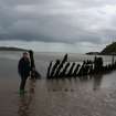
During the 2015 community engagement fieldwork for SAMPHIRE, a vessel was reported to the team by Keith Armstrong-Clark, the local harbour master at Kirkcudbright. The remains of a vessel identified by locals as the Monrieth of Wigtown are located south of Kirkcudbright in Goat Well Bay. The vessel is visible at low tide and the SAMPHIRE team was able to visit the site during community engagement fieldwork. Later research demonstrated that this site was already known but the SAMPHIRE project has been able to gather some additional images and construction detail.
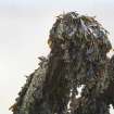
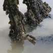
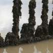
The remains consist of a wooden hull, complete from stem to stern, though much of the lower hull is still buried in the intertidal sands. The exposed portions of the vessel consist of second and third futtocks and the remaining stem and stern structures. The exposed remains are heavily covered in seaweed but iron fastenings are still visible. It is probable that wooden treenails were used in the construction as well but were not visible due to the vegetation.
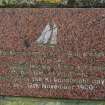
The Monrieth was a schooner built in Wigtown in 1876 with a gross registered tonnage of 64 tons. The vessel ran aground on the 11th of November 1900, with a cargo of stone bound for Kirkcudbright. The National Inventory lists two entries for this site. One relates to the reported loss of the vessel and current location of the vessel (CANMORE 125031). This entry includes notes of an entry about the site made by the Scotland's Coastal Heritage at Risk (SCHARP) project in 2013. A second entry (CANMORE 101629) relating to the same wreck appears in the National Inventory and is derived from UKHO entries and aerial surveys in the same vicinity. A plaque commemorating the wreck has been erected nearby.
Coordinates: 265905,548355
Accuracy: 10m
SAMPHIRE ID: 157

