
North Uist, Balranald, Sithean Tuath


Burnt Mound (Prehistoric)(Possible), Mound (Period Unassigned)
Site Name North Uist, Balranald, Sithean Tuath
Classification Burnt Mound (Prehistoric)(Possible), Mound (Period Unassigned)
Canmore ID 10126
Site Number NF77SW 6
NGR NF 71930 70176
Datum OSGB36 - NGR
Permalink http://canmore.org.uk/site/10126


- Council Western Isles
- Parish North Uist
- Former Region Western Isles Islands Area
- Former District Western Isles
- Former County Inverness-shire
NF77SW 6 7193 7017.
(NF 7193 7017) Sithean Tuath (NAT)
OS 6"map, Inverness-shire, 2nd ed., (1904)
Sithean Tuath, a small hillock 50ft across and 7 to 8ft high, with a summit 26ft in diameter, was doubtless at one time an islet in the loch. Its base has apparently been surrounded by a wall, which suggests that it may be the site of a dun.
E Beveridge 1911.
Sithean Tuath is a conspicuous, grass-covered, earthen mound, as described above. It is unlikely to have been the site of a dun. Resurveyed at 1/2500.
Visited by OS (J T T) 16 June 1965.
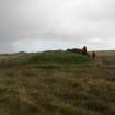
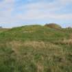
This site is oval on plan, some 15m N-S by 12m and over 2m high, and stands in a boggy area, perhaps formerly the edge of a loch. Erosion by stock has revealed that the mound is composed of large quantities of small fire-cracked stones. Traces of larger stones near the base may indicate some underlying structure. This is, so far as the contributor is aware, the first convincing burnt mound identified in the Outer Hebrides. The place-name suggests a pre-medieval date.
N Fojut 1994.
Reference (1911)
Sithean Tuath, or 'north fairy-knoll', a quarter of amile north of Balranald House, is a small hillock rising abruptly in a marsh at the south end of Loch Scarie, and was doubtless once an islet in that loch, which flows into Loch Grogary, and, like it, has evidently been reduced in level by drainage operations. This mound measures about 50 feet across by 7 or 8 feet in present height, with steep edges and a flattened summit 26 feet in diameter. Its base has apparently been surrounded by a wall, and general indications would point to this being the former site of a dun.
Beveridge 1911, 190
fn. Inferentially, a 'Sithean Deas' or 'south fairy-knoll' ought to exist. It seems possible that this may be reprsented by Dun na Dise on Baleshare Strand, or even by Carn na Dise near the shore at Claddach-Baleshare; but see p182, antea.
Desk Based Assessment (14 January 1965)
(NF 7193 7017) Sithean Tuath (NAT)
OS 6"map, Inverness-shire, 2nd ed., (1904)
Sithean Tuath, a small hillock 50ft across and 7 to 8ft high, with a summit 26ft in diameter, was doubtless at one time an islet in the loch. Its base has apparently been surrounded by a wall, which suggests that it may be the site of a dun.
Information from OS (BRS) 14 January 1965
E Beveridge 1911.
Field Visit (16 June 1965)
Sithean Tuath is a conspicuous, grass-covered, earthen mound, as described above. It is unlikely to have been the site of a dun. Resurveyed at 1/2500.
Visited by OS (J T T) 16 June 1965.
Field Visit (1994)
This site is oval on plan, some 15m N-S by 12m and over 2m high, and stands in a boggy area, perhaps formerly the edge of a loch. Erosion by stock has revealed that the mound is composed of large quantities of small fire-cracked stones. Traces of larger stones near the base may indicate some underlying structure. This is, so far as the contributor is aware, the first convincing burnt mound identified in the Outer Hebrides. The place-name suggests a pre-medieval date.
N Fojut 1994.
Field Visit (14 September 2012)
Sithean Tuath or ‘north fairy-knoll’ is a conspicuous mound situated in the drained but still marshy fields between Loch Brinishader and Loch Scaraidh. Oval on plan, it measures 15.4m from ENE to WSW by 14m transversely and rises steeply 2.8m to a flat top about 8m in diameter. A large scoop, probably a quarry or robber-trench, has removed the E part of the summit; much of the remainder of the mound is riddled with rabbit burrows.
The mound is encircled by a slight ditch and bank, the overall character of which suggests they are later in date than the mound. The ditch measures up to 1m in breadth and 0.3m in depth. A counterscarp bank is visible at the W, measuring only 0.5m across and about 0.2m in height. This ditch has in turn been cut by a large drainage channel that passes close to the mound on its NNW side. The ground outside the encircling ditch appears to be slightly lower than that within the ditch, at the foot of the mound, a situation that may indicate stripping of the outer area for fuel.
There is now nothing about this site to suggest that it is either a dun or a burnt mound. Having said that, recent communication with Mr Noel Fojut confirmed that, in 1994, when the site was visited with Miss Mary Harman, they noted that it appeared to be constructed entirely of burnt fragments of stone.
Visited by RCAHMS (GFG, AW, IP) 14 September 2012
Measured Survey (14 September 2012)
RCAHMS surveyed the mound at Sithean Tuath on 14 September 2012 with plane-table and alidade producing a plan and two sections at a scale of 1:250.
Measured Survey (1 April 2021 - 13 October 2021)
NF 80980 72840, NF 86430 73810, NF 84320 73660, NF 71930
70170, NF 81580 60300 During 2021, preliminary survey work on 140 island dun sites across Uist was carried out by members of the Uist Community Archaeology Group on behalf of the Islands of Stone research project being undertaken by Southampton and Reading Universities.
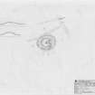
When visiting Dun Eshader, an island dun in Loch Eisiadair which lies around 2km south of Sollas on North Uist (Canmore 10375), UCAG members Roger Auger and David Newman also visited another site on the loch’s N shore at NF 8099 7284. This site had been previously recorded by a 2016 HES aerial survey and classified as an enclosure (Canmore 351277; and A on sketch plan). From the air the site shows as a slumped sub-circular turf bank around 30m in diameter, but what the photo did not reveal is that the area within is almost entirely occupied by a natural mound around 4m high, which is a feature not normally seen within other recorded enclosures and livestock folds on the island. The surveyors also noted its similarity to another unrecorded site lying around 6km NE within the grazings of the township of Ahmor at NF 8643 7381 in an area known as Cnoc Sitheal (B on sketch plan). Here, another natural mound is enclosed around its base by a turf bank. A similar feature, although enclosing a lower mound, lies at the junction of three boundary dykes around 2km to the W at NF 8433 7367 (C on sketch plan).
Two other, albeit smaller, mound/sub-circular enclosure
combinations have been identified on North Uist at Sidhean Tuath at Balranald (Canmore 10126, E on sketch plan) and 40m NW of Teampuill Trionaid at Carinish at NF 8158 6030 (D on sketch plan, and shown on photo). According to Canmore, the mound at Sidhean Tuath may be a burnt mound and the bank runs tight to the mound base and is itself surrounded by a ditch. In the latter case, the enclosure/mound arrangement is reversed, with the bank enclosing a flattened area of ground on the summit of what appears to be a natural mound. The possibility exists that this unusual combination of mounds and enclosures represents an, as yet unidentified, site class. Alternatively, mound sites are known to have been used as ‘thing’ or assembly site locations, in the late medieval period where people came to resolve disputes. A similar tradition is recorded in the Hebrides in the early modern period when township tenants gathered at a traditional place to make decisions about land and grazing allocations as part of the communal run-rig system.
Roger Auger and David Newman – Uist Community Archaeology Group
(Source: DES Vol 22)

