 |
On-line Digital Images |
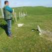
DP 150849 |
RCAHMS digital photography |
The stone from the WNW with Mr John Sherriff to the left |
30/5/2012 |
Item Level |
|
 |
On-line Digital Images |
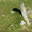
DP 150850 |
RCAHMS digital photography |
The stone from the WNW |
30/5/2012 |
Item Level |
|
 |
On-line Digital Images |
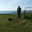
DP 150851 |
RCAHMS digital photography |
The stone from the SSW, with Mr John Sherriff standing behind it |
30/5/2012 |
Item Level |
|
 |
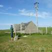
On-line Digital Images |
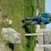
DP 150852 |
RCAHMS digital photography |
The stone from the ESE. Mr John Sherriff is establishing its position with a GPS unit |
30/5/2012 |
Item Level |
|
 |
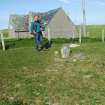
On-line Digital Images |
DP 150853 |
RCAHMS digital photography |
The stone from the SSW, with Mr John Sherriff establishing its position with a GPS handheld unit |
30/5/2012 |
Item Level |
|
 |
On-line Digital Images |
DP 150854 |
RCAHMS digital photography |
The stone from the SW with Mr John Sherriff |
30/5/2012 |
Item Level |
|
 |
On-line Digital Images |
SC 2356761 |
Records of the Ordnance Survey, Southampton, Hampshire, England |
North Uist, Tigharry, NF77SW 4, Ordnance Survey index card, Recto |
1958 |
Item Level |
|
 |
On-line Digital Images |
SC 2356762 |
Records of the Ordnance Survey, Southampton, Hampshire, England |
North Uist, Tigharry, NF77SW 4, Ordnance Survey index card, Recto |
1958 |
Item Level |
|
|
All Other |
551 166/1/1 |
Records of the Ordnance Survey, Southampton, Hampshire, England |
Archaeological site card index ('495' cards) |
1947 |
Sub-Group Level |
|


