 |
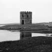
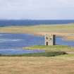
On-line Digital Images |
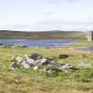
SC 972620 |
|
View from SW. |
3/1969 |
Item Level |
|
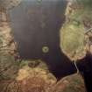 |
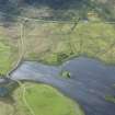
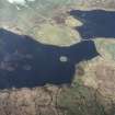
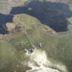
On-line Digital Images |
SC 1004382 |
RCAHMS Aerial Photography |
Oblique aerial view centred on the tower and remains of the dun with the remains of the township adjacent, taken from the ESE. |
22/4/2005 |
Item Level |
|
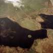 |
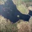
On-line Digital Images |
SC 1004383 |
RCAHMS Aerial Photography |
Oblique aerial view centred on the tower and remains of the dun with the house, farmstead and the remains of the township adjacent, taken from the SSE. |
22/4/2005 |
Item Level |
|
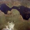 |
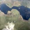
On-line Digital Images |
SC 1004384 |
RCAHMS Aerial Photography |
Oblique aerial view centred on the farmstead and house with the tower and remains of the dun and township adjacent, taken from the NW. |
22/4/2005 |
Item Level |
|
 |
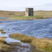
On-line Digital Images |
DP 067359 |
Records of the Royal Commission on the Ancient and Historical Monuments of Scotland (RCAHMS), Edinbu |
General view from S |
30/9/2009 |
Item Level |
|
 |
On-line Digital Images |
DP 067360 |
Records of the Royal Commission on the Ancient and Historical Monuments of Scotland (RCAHMS), Edinbu |
Distant view from S |
30/9/2009 |
Item Level |
|
 |
On-line Digital Images |
DP 067361 |
Records of the Royal Commission on the Ancient and Historical Monuments of Scotland (RCAHMS), Edinbu |
Distant view from S |
30/9/2009 |
Item Level |
|
 |
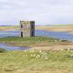
On-line Digital Images |
DP 067363 |
Records of the Royal Commission on the Ancient and Historical Monuments of Scotland (RCAHMS), Edinbu |
View from E |
30/9/2009 |
Item Level |
|
 |
On-line Digital Images |
DP 067364 |
Records of the Royal Commission on the Ancient and Historical Monuments of Scotland (RCAHMS), Edinbu |
General view from SE |
30/9/2009 |
Item Level |
|
 |
On-line Digital Images |
DP 067365 |
Records of the Royal Commission on the Ancient and Historical Monuments of Scotland (RCAHMS), Edinbu |
View from S |
30/9/2009 |
Item Level |
|
 |
On-line Digital Images |
DP 067366 |
Records of the Royal Commission on the Ancient and Historical Monuments of Scotland (RCAHMS), Edinbu |
View from S |
30/9/2009 |
Item Level |
|
 |
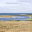
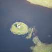
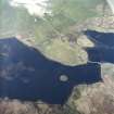
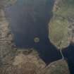
On-line Digital Images |
DP 235532 |
Historic Environment Scotland |
Oblique aerial view. |
3/6/2016 |
Item Level |
|
 |
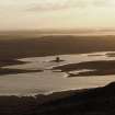
On-line Digital Images |
DP 235533 |
Historic Environment Scotland |
Oblique aerial view. |
3/6/2016 |
Item Level |
|
 |
On-line Digital Images |
DP 235535 |
Historic Environment Scotland |
Oblique aerial view. |
3/6/2016 |
Item Level |
|
 |
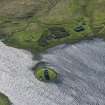
On-line Digital Images |
SC 1691299 |
RCAHMS Aerial Photography |
Oblique aerial view centred on the tower and remains of the dun with the remains of the township adjacent, taken from the S. |
22/4/2005 |
Item Level |
|
 |
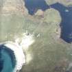
On-line Digital Images |
SC 1691300 |
RCAHMS Aerial Photography |
Oblique aerial view centred on the tower and remains of the dun with the remains of the township adjacent, taken from the SE. |
22/4/2005 |
Item Level |
|
 |
On-line Digital Images |
SC 1691302 |
RCAHMS Aerial Photography |
Oblique aerial view centred on the farmstead and house with the tower and remains of the dun adjacent, taken from the NNW. |
22/4/2005 |
Item Level |
|
 |
On-line Digital Images |
SC 1691303 |
RCAHMS Aerial Photography |
Oblique aerial view centred on the farmstead and house with the tower and remains of the dun and township adjacent, taken from the NW. |
22/4/2005 |
Item Level |
|
 |
On-line Digital Images |
SC 1691304 |
RCAHMS Aerial Photography |
Oblique aerial view centred on the farmstead and house with the tower and remains of the dun adjacent, taken from the WNW. |
22/4/2005 |
Item Level |
|
 |
On-line Digital Images |
SC 1694006 |
RCAHMS Aerial Photography |
Oblique aerial view centred on the tower and remains of the dun with the house, farmstead and the remains of the township adjacent, taken from the SSE. |
22/4/2005 |
Item Level |
|
 |
On-line Digital Images |
SC 1694007 |
RCAHMS Aerial Photography |
Oblique aerial view centred on the tower and remains of the dun with the remains of the township adjacent, taken from the ESE. |
22/4/2005 |
Item Level |
|
 |
On-line Digital Images |
DP 235534 |
Historic Environment Scotland |
Oblique aerial view. |
3/6/2016 |
Item Level |
|
 |
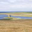
On-line Digital Images |
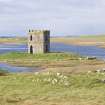
DP 338806 |
Papers of Dr George F Geddes, archaeologist, Edinburgh, Scotland |
General view centred on Scolpaig Tower |
26/10/2020 |
Item Level |
|
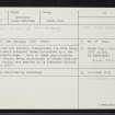 |
On-line Digital Images |
SC 2356646 |
Records of the Ordnance Survey, Southampton, Hampshire, England |
North Uist, Loch Scolpaig, Dun Scolpaig, NF77NW 6, Ordnance Survey index card, Recto |
1958 |
Item Level |
|


