
North Uist, Baleshare, Ceardach Ruadh


Cist (Iron Age), Grave (Iron Age), Inhumation(S) (Iron Age), Midden (Iron Age), Wheelhouse (Iron Age), Animal Remains (Bone)(Iron Age), Unidentified Pottery(S) (Iron Age), Weight (Iron Age)(Possible)
Site Name North Uist, Baleshare, Ceardach Ruadh
Classification Cist (Iron Age), Grave (Iron Age), Inhumation(S) (Iron Age), Midden (Iron Age), Wheelhouse (Iron Age), Animal Remains (Bone)(Iron Age), Unidentified Pottery(S) (Iron Age), Weight (Iron Age)(Possible)
Alternative Name(s) A' Ceardach Ruadh
Canmore ID 10026
Site Number NF76SE 9
NGR NF 7763 6157
Datum OSGB36 - NGR
Permalink http://canmore.org.uk/site/10026


- Council Western Isles
- Parish North Uist
- Former Region Western Isles Islands Area
- Former District Western Isles
- Former County Inverness-shire
NF76SE 9 7763 6157.
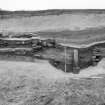
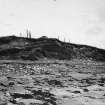
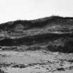
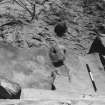
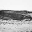
(Area : NF 776 617) Remains of what appears to be a wheel house, exposed by coastal erosion, are situated at A'Ceardach Ruadh (The Red Smiddy) on the west side of Baleshare Island where the machair ends in a sandy cliff above the beach. Two distinct floors were recognisable 8 or 9ft above HWMOST, and beneath the floors there was a deposit of stained sand with thick sherds.
About 40 sherds of thinner, typical undecorated 'wheelhouse' pottery were found along the foot of the cliff, all apparently from the wheelhouse. (H Fairhurst and W Ritchie 1963)
E Beveridge (1911) found slag and ashes here in quantity, and objects of flint, antler & pottery. He adds, apparently speaking of the area generally, '...Here cists and bones are sometimes disclosed... and pins of bone and brass have been found.'
The finds are in the National Museum of Antiquities of Scotland (NMAS). (PSAS 1922)
(E Beveridge 1911; Proc Soc Antiq Scot 1922; H Fairhurst and W Ritchie 1963).
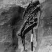
NF 775 617. A skeleton was excavated in September 1964 at the Ceardach Ruadh prehistoric site. Details of the excavation are held by Mr Crawford.
(I A Crawford 1964).
This site, at NF 7763 6157, is in the early stages of excavation. Without further information from the excavators it cannot be readily identified as a wheel-house.
Visited by OS (J T T) 31 May 1965.
Field Visit (7 September 1914)
Kitchen Midden, Ceardach Ruadh, Baleshare.
[NF76SE 9] About ½ mile north-west of Teampull Chriosd, on a high sandhill near the sea-shore, is a kitchen midden with some loose stones on the summit, perhaps the remains of a hut circle. Unornamented pottery, pumice, bones of animals and shells of winkles and limpets, the former most numerous, as well as a few pieces of iron, were noted. A large block of whale bone 9 ½ inches by 9 ½ inches by 7 inches, with two holes on top near one side 2 ½ inches and 1 5/8 inches in diameter and 2 ½ inches and 1 ½ inches deep, was found and retained for the National Museum. Human burials and pins of bronze and bone have been found here, as well as flints and bits of deer horn.
[NF76SE 19] About ½ mile south of above are extensive kitchen middens at a place called Sloc Sabhaidh. Burials have been found here, also plain pottery and animal bones, winkles predominating among shells. At one place cockles were the only shells. Two good selections of deposits were seen: one to the north, 1 foot thick, showed three layers of winkles with sand between, and another at the south showed a thickness of about 2 feet.
RCAHMS 1928, visited 7 September 1914.
OS map: North Uist xxxix (unnoted).
Note (1973)
A local informant states that sherds of ancient pottery are often found at Ceardach Ruadh.
I Fraser 1973.
Environmental Sampling (1984)
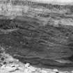
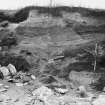
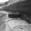
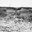
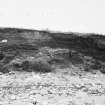
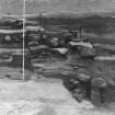
NF 776 615 The site was initially cored to establish the horizontal extent of the midden exposed in the sand dune by erosion. Humus-stained sand and midden deposits were found up to 100m from the beach and for at least 50m along its length. The midden face was straightened, drawn and sampled. The partial remains of a drystone circular structure and other stone structures were found. On either side, the midden was about 3m in depth beneath 1m of clean sand. A second midden was found beneath the first, separated from it by about 0.5m of clean sand.
J Barber 1984c.
Excavation (1993)
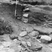
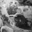
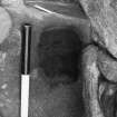
NF 776 615 Small-scale salvage excavation of a cist burial, together with an assessment of coastal erosion was carried out on this previously excavated site. Tidal erosion has removed approximately 7m to 8m of the beach-front in the past 10 years and continues to expose cultivated soils and midden associated with the previously excavated prehistoric structures. Cut into the upper part of these deposits was a long cist containing an extended unhumation.
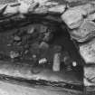
The cist was overlain by stained sand with indistinct layer boundaries, over a buried soil of dark-brown sand, some 0.05m deep. This latter soil extended unbroken over the cist, separated from it by a thin layer of stained, grey-brown sand, indicating that the cist was roofed originally at ground level. The cist was cut directly into the top of layers rich in peat ash and other indicators of domestic midden. Less than half of the cist survived, the remainder having fallen onto the beach. The surviving structure indicated that the cist had been in excess of 1.3m in length, with a width at the surviving end of 0.5m, and a depth of 0.4m. It was lined with side slabs of local gneiss and capped wirth lintels of the same material. Two lintels survived of which the one nearest the erosion face had partially slipped, crushing and wdging the upper rib cage of the skeleton.
The skeletal material appears to represent the remains of an extended inhumation aligned NNW (the head) to SSE. Two cattle teeth were found in the area of the neck and shoulders of the skeleton. These were the only non-human skeletal material in the burial and appear to have been deliberately placed. The burial is most likely to be Later Iron Age in date.
Sponsor: Historic Scotland
I Armit 1993
Excavation (2001)
NF 776 615 Salvage excavation of a prone, male inhumation was carried out in May 2000. The skeleton was buried within the deep midden deposits of this known Iron Age site (NMRS NF 76 SE 9). It was oriented N-S, unaccompanied, in a shallow cut, and covered by a layer of white quartz beach pebbles. The surrounding layers of midden were virtually finds-free, and no dating evidence was recovered. It would seem likely, however, that the burial is part of the diffuse Iron Age cemetery known from earlier finds in this area.
Sponsor: Historic Scotland
M MacLeod 2001
Publication Account (2007)
NF76 1 A CHEARDACH RUADH ('Cheardach Ruadh', ‘Baleshare’)
NF/7763 6157
The remains of this probable wheel-house on Baleshare Island in North Uist have been exposed by coastal erosion (the name means 'The red smiddy'). Midden material in layers in the sand has been observed over the years, including plain “wheelhouse pottery” in an upper layer [3, 1963] and, in a lower level, thick sherds. Human remains have been excavated at the site but the Iron Age dwelling, if it exists, remains unexplored.
In the 1980s a programme of recording eroding archaeological sites in Baleshare was undertaken and a vast amount of data collected [9]. The methodology employed meant that only the eroding sections of sites were explored and that their nature could not be investigated in depth. One of the sites is thought to have been near or at the supposed wheelhouse and dumped material in a stone passage (‘Block 7’) revealed most of a pot which bears a remarkable resemblance to that found in 1956 at Bruthach a’ Tuath (NF75 1) in Benbecula [9, photo on p. 43]. The stratified sequence of radiocarbon dates obtained suggests that the Block 7 deposits, though not themselves dated, fall between about 2250 and 2120 bp [9, 40] – that is probably in about the 3rd century BC.
Sources: 1. NMRS site no. NF 76 SE 9: 2. Beveridge 1911, 229: 3. Discovery and Excavation in Scotland 1963, 31-2: Ibid. 1964, 33: Ibid 1975, 60: Ibid. 1984, 44: Ibid. 1993, 113: Ibid. 2001, 102: 4. Armit 1996, 28, 99, 149: 5. Gilmour 2002, 57: 6. Proc Soc Antiq Scot 56 (1921-22), 16 (donation): 7. Proc Soc Antiq Scot 105 (1972-74), 325 (donation): 8. Proc Soc Antiq Scot 107 (1975-76), 333 (donation): 9. See the Scottish Archaeology Internet Report at http://www.sair.org.uk/sair3/.
E W MacKie 2007
Excavation (2009)
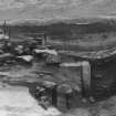
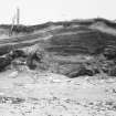
NF 7754 6172 A small rescue excavation was carried out at the extensive midden and settlement site at Ceardach Ruadh, (NF76SE 9). Local school children helped to carry out the excavation as part of a collaborative project organised by the cultural co-ordinator service of the CNES education department, the Access Archaeology group and Uist Archaeology. The excavation focused on a small area on the foreshore where archaeological deposits had recently been exposed through erosion.
The excavation revealed the remains of a possible Iron Age wheelhouse. An area of shingle was cleared, exposing deep floor deposits abutting a possible pier. Large amounts of animal bone and pottery were recovered from the floor deposits. Small finds included an almost complete pot and a single piece of flint. The pottery included wavy cordon decorations and everted rim ware indicating middle to late Iron Age dates. The remains lie 20m to the N of Iron Age structures and burials excavated in the 1960s to 1990s (NF76SE 9), and
are probably part of the same settlement complex.
Archive and Report: CNES SMR and RCAHMS (intended)
Funder: Comhairle Nan Eilean Siar
Kate MacDonald and Rebecca Rennell – Uist Archaeology 2009
Excavation (6 January 2012 - 18 January 2012)
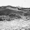
NF 77630 61590 An excavation was undertaken 6–18 January 2012 of a possible cremation urn, which had been discovered in eroding sand dunes. The ongoing erosion has created 4m high W-facing dunes and the urn was exposed near the base of a sequence of midden deposits. The midden extends c40m to the N, 10m to the S and is c1.5m deep.
The pot had been deliberately deposited above a layer of midden material. Although the base of the pot was intact the vessel was not complete and only one side of the pot, which had collapsed, was in situ. The pot is an undecorated, straight-sided, bucket-shaped vessel, and has a straight rim with a slightly bevelled interior. The pot contained nine quartz pebbles within loose dark brown sand. There was no evidence that the pot had contained cremated material. However, a thin black residue was visible on the inner surface of the pot. The contents of the pot were recovered for further analysis. The pot was covered by further midden deposits. A setting of five, irregular shaped stones which had been set within one of the upper deposits may have been placed to mark the pot’s location. Further midden deposits had accumulated above the stone marked layer, one of which contained several pieces of plain pottery, a bone point and unworked bone.
A large amount of archaeological material has been recorded at Ceardach Ruadh over the last century, and the progressive and ongoing erosion has revealed a complex sequence of Late Bronze Age to Late Iron Age activity, as well as a number of burials. It is probable that the pot and midden form part of this prehistoric settlement complex.
Archive and report: RCAHMS (intended). Report: CNES SMR
Funder: Historic Scotland
Kate MacDonald, Uist Archaeology
Rebecca Rennell,
2012
Field Visit (22 September 2014)
ShoreUPDATE:
A 2-3m thickness of midden material comprising peat ash with frequent marine shell, bone and pot exposed along 50-60m of eroding dune face. A small amount of stone, just appearing appears to be laid horizontally. No sign of other stone structures yet. They may survive in the mound of which the midden forms the seaward side.
This is almost certainly the beginnings of the erosion of a further wheelhouse; part of the settlement of which wheelhouse 9609 c. 200m to the north is part.
Visited by Scotland's Coastal Heritage at Risk (SCHARP) 22 September 2014
Casual Observation (2016)
NF 7763 6157 A bone femur head, cut to a hemisphere and perforated, was found casually. Such objects may be weights or gaming pieces.
Claimed as Treasure Trove (TT 30/16), allocated to Museum nan Eilean
Fraser Hunter – National Museums Scotland
(Source: DES, Volume 17)
Note (2020)
Baleshare
This burial site in Western Isles was a focus for funerary practices in the Iron Age period, between 400 BC and AD 300.
Prehistoric Grave Goods project site ID: 60182
CANMORE ID: 10026
Total no. graves with grave goods: 1
Total no. people with grave goods: 1
Total no. grave goods: 1
Prehistoric Grave Goods project Grave ID: 60072
Grave type: Grave
Burial type(s): Inhumation
Grave good: Assemblage
Materials used: Quartz/Quartzite
Current museum location: Unknown
Further details, the full project database and downloads of project publications can be found here: https://doi.org/10.5284/1052206
An accessible visualisation of the database can be found here: http://blogs.reading.ac.uk/grave-goods/map/
Excavation (11 August 2021)
NF 77624 61607 This report presents the results of the excavation of a crouched burial eroding out of a west facing coastal sand dune at Balshare, North Uist. The excavation was undertaken on 11 August 2021.
Human remains were identified eroding from a dune of a known Iron Age midden and settlement by members of the public and reported to Police Scotland. At the time of discovery, it was assumed the remainder of the skeleton was situated within the dune face.
The subsequent excavation revealed a crouched inhumation with a diffuse grave cut. The bones were in mostly good preservation with small bones remaining, albeit disturbed by the presence of a large stone. The burial was aligned NW–SE with the head to the SE facing NE. The grave cut was not visible until excavated, which suggests that the burial possibly pre-dates the later midden deposits.
The burial is in close proximity to multiple inhumations and a known Iron Age settlement and extensive midden deposits.
Several sherds of pottery and animal bone was recovered from the burial. None can necessarily be directly tied to the inhumation due to the extensive midden deposits.
No further features were immediately apparent in the eroding dunes; however, the midden was visible throughout the majority of the northern half of the beach, with obvious patches of periwinkle shell and animal bone. Further outside the excavation zone large quantities of stone were suggestive of the known North Atlantic Wheelhouses.
Archive: NRHE (intended)
Funder: Historic Environment Scotland
Steven Watt – AOC Archaeology Group
(Source: DES Vol 22)

