
Drs Colin and Paula Martin


18/03/2014
RCAHMS have published a new 'wreck map' showing the density of 1,200 years of shipwrecks in Scottish waters as part of a drive to enhance the maritime record for Scotland. This map was produced as part of Project Adair, a partnership between RCAHMS and Historic Scotland to collate and promote information on the marine historic environment.
The project has drawn on records from commercial consultants WA Coastal and Marine and ORCA, and thousands of records held digitally in the RCAHMS online database Canmore. These include a huge private collection of photographs and materials recently donated to RCAHMS by the pioneer of nautical archaeology in Scotland, Colin Martin. The Colin and Paula Martin collection comprises 1,200 digital images of never-before published photographs of shipwreck dives off the coast of Scotland.
The national maritime record for Scotland is now greatly increased, with nearly four times more records of shipwrecks and a 40 per cent increase in maritime records overall. Freely available to the public, the records, photographs and data can be accessed via Canmore.


SC 1312976
A diving archaeologist conducting a metal-detector survey in Gulley B. The rounded boulders in the foreground are typical of the fill of gulleys on the Adelaar wreck-site, indicative of the dynamic environment which moves them around. Weed growing on the vertical sides of the gulley is visible to left and right
© Courtesy of HES (Dr Colin and Dr Paula Martin Collection)

SC 1312983
Raising the bronze 6-pounder with an ingenious device created by Chis Oldfield. He has welded a 4-legged construction to an abandoned fuel bowser and has secured a pipe between its top and bottom surfaces. This has allowed a wire to drop vertically to the sea-bed where it is secured with webbing straps to the underside of the gun. A simple hand-operated hoist is then used to lift the 1-ton object until it is right underneath the bowser.
© Courtesy of HES (Dr Colin and Dr Paula Martin Collection)

SC 1313010
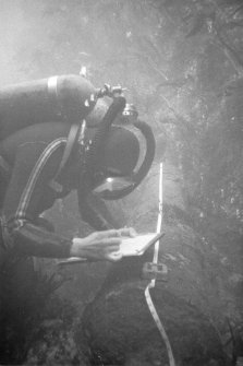
An archaeologist on the wreck-site recording in situ a cast-iron gun from which the concretion has been removed.
© Courtesy of HES (Dr Colin and Dr Paula Martin Collection)

SC 1313012
A cast-iron gun lying in shallow water at the inshore side of the wreck. The thick and luxuriant growth of the kelp (Laminaria digitata) is very evident.
© Courtesy of HES (Dr Colin and Dr Paula Martin Collection)


SC 1313013
An archaeologist on the wreck-site recording in situ a cast-iron gun from which the concretion has been removed.
© Courtesy of HES (Dr Colin and Dr Paula Martin Collection)

SC 1313116
Gold jewellery from the wreck-site.
© Courtesy of HES (Dr Colin and Dr Paula Martin Collection)

SC 1313118
Detail of gold finger ring 033 marked with the Amsterdam arms, the letters "P", DR" and a lion rampant. The maker has not been identified
© Courtesy of HES (Dr Colin and Dr Paula Martin Collection)

SC 1313146
Bronze breech-loading swivel-gun with the A-VOC cipher. It lacks the breech-block which would have contained the powder charge. The piece would have fired a 4-pound solid iron shot or, more probably, containers filled with lead shot or iron scrap.
© Courtesy of HES (Dr Colin and Dr Paula Martin Collection)


SC 1325754
Jeremy Green (left) of the Western Australian Maritime Museum and Professor David Switzer of Plymouth State University, New Hampshire, at work on the project. Several distinguished foreign visitors participated in the project during these early years of the evolution of maritime archaeology as a serious discipline, in which Scotland played a leading part.
© Courtesy of HES (Dr Colin and Dr Paula Martin Collection)

SC 1325778
Tony Long displays a gold coin (D1001) recovered during excavation.
© Courtesy of HES (Dr Colin and Dr Paula Martin Collection)

SC 1326347
Gold guineas of William and Mary (left) and James II (right), obverse. Diameter 25mm.
© Courtesy of HES (Dr Colin and Dr Paula Martin Collection)

SC 1326625
Archaeologist Colin Martin making the salvage cut. (Jeremy Green)
© Courtesy of HES (Dr Colin and Dr Paula Martin Collection)


SC 1326636
Self-portrait of Colin Martin, taken on the Dartmouth site.
© Courtesy of HES (Dr Colin and Dr Paula Martin Collection)

SC 1326642
Waterlogged wood is only slightly heavier than water, so in the underwater environment it is virtually weightless, making it easy to handle and transport. (Tony Long)
© Courtesy of HES (Dr Colin and Dr Paula Martin Collection)

SC 1326688
Tony Long carrying one of the loose timbers ashore.
© Courtesy of HES (Dr Colin and Dr Paula Martin Collection)

DP 151103
The bronze media culebrina suspended under two air-filled lifting-bags (1977).
© Courtesy of HES (Dr Colin and Dr Paula Martin Collection)


DP 151104
Colin Martin prepares for his first exploratory dive in Stroms Hellier on 11 May 1970. (Roy Dennis)
© Courtesy of HES (Dr Colin and Dr Paula Martin Collection)

DP 151106
The 1970 team at North Haven with their Grant all-terrain vehicle. From left: Chris Oldfield, Simon Martin (seated), Sydney Wignall and Colin Martin. (photographer unknown)
© Courtesy of HES (Dr Colin and Dr Paula Martin Collection)

DP 151108
Raising the bronze media sacre (1970).
© Courtesy of HES (Dr Colin and Dr Paula Martin Collection)

DP 151111
The 1970 team on the pier at North Haven, Fair Isle, with guns recovered from the wreck. From left: Simon Martin, Sydney Wignall, Colin Martin and Chris Oldfield. (photographer unknown)
© Courtesy of HES (Dr Colin and Dr Paula Martin Collection)


DP 151119
The industrial compressor on the cliff-top used to power the airlift (1977).
© Courtesy of HES (Dr Colin and Dr Paula Martin Collection)

DP 151133
The bronze media sacre is hoisted ashore at North Haven with the assistance of the crew of the Good Shepherd, watched by Chris Oldfield (1970). (photographer unknown)
© Courtesy of HES (Dr Colin and Dr Paula Martin Collection)

DP 151140
The cliff-top base above Stroms Hellier with team members Keith Muckelroy (left) and Paula Martin (right) (1977).
© Courtesy of HES (Dr Colin and Dr Paula Martin Collection)

DP 151147
The bronze media culebrina is hoisted ashore at North Haven (1977).
© Courtesy of HES (Dr Colin and Dr Paula Martin Collection)


DP 151153
Tony Long servicing the airlift compressor (1977). (Paula Martin)
© Courtesy of HES (Dr Colin and Dr Paula Martin Collection)
SC 1312976
A diving archaeologist conducting a metal-detector survey in Gulley B. The rounded boulders in the foreground are typical of the fill of gulleys on the Adelaar wreck-site, indicative of the dynamic environment which moves them around. Weed growing on the vertical sides of the gulley is visible to left and right
© Courtesy of HES (Dr Colin and Dr Paula Martin Collection)
SC 1312983
Raising the bronze 6-pounder with an ingenious device created by Chis Oldfield. He has welded a 4-legged construction to an abandoned fuel bowser and has secured a pipe between its top and bottom surfaces. This has allowed a wire to drop vertically to the sea-bed where it is secured with webbing straps to the underside of the gun. A simple hand-operated hoist is then used to lift the 1-ton object until it is right underneath the bowser.
© Courtesy of HES (Dr Colin and Dr Paula Martin Collection)
SC 1313010
An archaeologist on the wreck-site recording in situ a cast-iron gun from which the concretion has been removed.
© Courtesy of HES (Dr Colin and Dr Paula Martin Collection)
SC 1313012
A cast-iron gun lying in shallow water at the inshore side of the wreck. The thick and luxuriant growth of the kelp (Laminaria digitata) is very evident.
© Courtesy of HES (Dr Colin and Dr Paula Martin Collection)
SC 1313013
An archaeologist on the wreck-site recording in situ a cast-iron gun from which the concretion has been removed.
© Courtesy of HES (Dr Colin and Dr Paula Martin Collection)
SC 1313116
Gold jewellery from the wreck-site.
© Courtesy of HES (Dr Colin and Dr Paula Martin Collection)
SC 1313118
Detail of gold finger ring 033 marked with the Amsterdam arms, the letters "P", DR" and a lion rampant. The maker has not been identified
© Courtesy of HES (Dr Colin and Dr Paula Martin Collection)
SC 1313146
Bronze breech-loading swivel-gun with the A-VOC cipher. It lacks the breech-block which would have contained the powder charge. The piece would have fired a 4-pound solid iron shot or, more probably, containers filled with lead shot or iron scrap.
© Courtesy of HES (Dr Colin and Dr Paula Martin Collection)
SC 1325754
Jeremy Green (left) of the Western Australian Maritime Museum and Professor David Switzer of Plymouth State University, New Hampshire, at work on the project. Several distinguished foreign visitors participated in the project during these early years of the evolution of maritime archaeology as a serious discipline, in which Scotland played a leading part.
© Courtesy of HES (Dr Colin and Dr Paula Martin Collection)
SC 1325778
Tony Long displays a gold coin (D1001) recovered during excavation.
© Courtesy of HES (Dr Colin and Dr Paula Martin Collection)
SC 1326347
Gold guineas of William and Mary (left) and James II (right), obverse. Diameter 25mm.
© Courtesy of HES (Dr Colin and Dr Paula Martin Collection)
SC 1326625
Archaeologist Colin Martin making the salvage cut. (Jeremy Green)
© Courtesy of HES (Dr Colin and Dr Paula Martin Collection)
SC 1326636
Self-portrait of Colin Martin, taken on the Dartmouth site.
© Courtesy of HES (Dr Colin and Dr Paula Martin Collection)
SC 1326642
Waterlogged wood is only slightly heavier than water, so in the underwater environment it is virtually weightless, making it easy to handle and transport. (Tony Long)
© Courtesy of HES (Dr Colin and Dr Paula Martin Collection)
SC 1326688
Tony Long carrying one of the loose timbers ashore.
© Courtesy of HES (Dr Colin and Dr Paula Martin Collection)
DP 151103
The bronze media culebrina suspended under two air-filled lifting-bags (1977).
© Courtesy of HES (Dr Colin and Dr Paula Martin Collection)
DP 151104
Colin Martin prepares for his first exploratory dive in Stroms Hellier on 11 May 1970. (Roy Dennis)
© Courtesy of HES (Dr Colin and Dr Paula Martin Collection)
DP 151106
The 1970 team at North Haven with their Grant all-terrain vehicle. From left: Chris Oldfield, Simon Martin (seated), Sydney Wignall and Colin Martin. (photographer unknown)
© Courtesy of HES (Dr Colin and Dr Paula Martin Collection)
DP 151108
Raising the bronze media sacre (1970).
© Courtesy of HES (Dr Colin and Dr Paula Martin Collection)
DP 151111
The 1970 team on the pier at North Haven, Fair Isle, with guns recovered from the wreck. From left: Simon Martin, Sydney Wignall, Colin Martin and Chris Oldfield. (photographer unknown)
© Courtesy of HES (Dr Colin and Dr Paula Martin Collection)
DP 151119
The industrial compressor on the cliff-top used to power the airlift (1977).
© Courtesy of HES (Dr Colin and Dr Paula Martin Collection)
DP 151133
The bronze media sacre is hoisted ashore at North Haven with the assistance of the crew of the Good Shepherd, watched by Chris Oldfield (1970). (photographer unknown)
© Courtesy of HES (Dr Colin and Dr Paula Martin Collection)
DP 151140
The cliff-top base above Stroms Hellier with team members Keith Muckelroy (left) and Paula Martin (right) (1977).
© Courtesy of HES (Dr Colin and Dr Paula Martin Collection)
DP 151147
The bronze media culebrina is hoisted ashore at North Haven (1977).
© Courtesy of HES (Dr Colin and Dr Paula Martin Collection)
DP 151153
Tony Long servicing the airlift compressor (1977). (Paula Martin)
© Courtesy of HES (Dr Colin and Dr Paula Martin Collection)
