
Archaeology on the National Forest Estate


13/03/2014
Duns and brochs form an important part of Scotland’s heritage, and one that often catches the popular imagination. RCAHMS has teamed up with Forestry Commission Scotland (FCS) to digitise over 100 plans and photographs of many sites, including some well-known brochs, supporting research and education projects undertaken by FCS and partners. The collection includes the drawings of the broch at Torwood near Stirling, recorded in detail by RCAHMS in the 1950s, as well as a series of images of the well-preserved broch Caisteal Grugaig, Glen Shiel. Making these images available online helps to promote not only the archaeological sites themselves but also the work of RCAHMS in recording and understanding our heritage, and that of FCS in actively managing and promoting significant sites on Scotland's national forest estate.


SC 721365
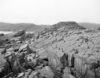
Copy of colour slide showing view of Dun Deardail, Glen Nevis, Highland. View of fort from S. ( slopes of Sgor Chalum) 1127ft above sea level NMRS Survey of Private Collection Digital Image Only
© Department of Archaeology, Glasgow University (Helen Nisbet Collection). Courtesy of HES


DP 168163
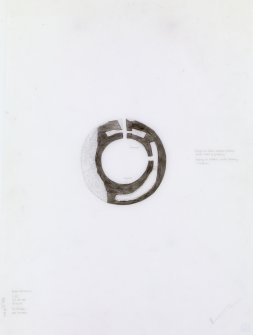
Plan and section of 'Broch at Dun Voradale' from NE.
© Courtesy of HES (Society of Antiquaries of Scotland Collection)

SC 1364844
Ink drawing of Hut-circle and field system at Druim Mor, Oronsay. Drawn for Argyll Inventory, vol 5.
© Crown Copyright: HES


SC 1367296
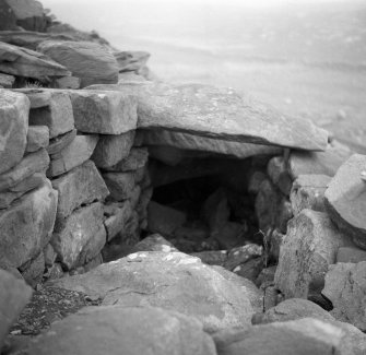
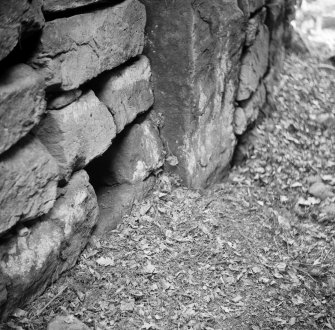
Caisteal Grugaig. Inner end of entrance passage, with aperture above the scarcement to right at level of lintel.
© Crown Copyright: HES


DP 170743
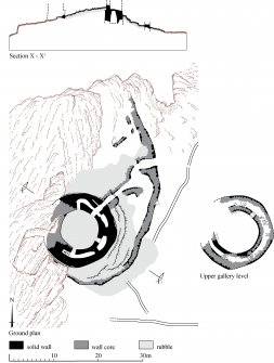
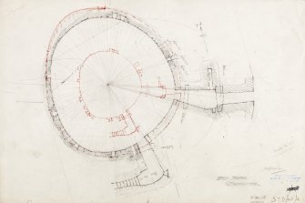
Plane-table survey of site: Torwood Broch. Photographic copy of STD 42/5.
© Crown Copyright: HES

SC 1367518
Plan and sections of the Vitrified Fort on Craig-Phatric near Inverness. (See also MS/974/1). Photographic copy of drawing.


DP 171696
Survey drawing, Druim An Duin: east elevation of the south entrance (1:20), site section (1:200).
© Crown Copyright: HES


SC 1376598
'Sketch of Craig Patrick by Mr Watt Engineer. Extract from Williams, J 1777 'An Account of some remarkable ancient ruins lately discovered in the highlands and the northern parts of Scotland. [photographic copy only]


DP 171764
Comparative plans of hillforts with timber-laced walls or ramparts in the NE province from Feachem in Rivet (ed) The Iron Age in N Britain.

SC 1401247
Oblique aerial view of the farmstead, farmsteading, and the the remains of the homestead, taken from the NNE.
© Crown Copyright: HES

SC 1401248
Oblique aerial view centred on the remains of the township, with the remains of the farmsteads, townships, homestead and burial-ground adjacent, taken from the NE.
© Crown Copyright: HES

SC 1401250
Oblique aerial view centred on the remains of the homestead and field-system with the remains of the hut-circle, homestead, building and township, taken from the NE.
© Crown Copyright: HES


SC 1401252
Oblique aerial view centred on the remains of the settlement, field system, possible sheiling-hut and enclosure, with the remains of the structure, field boundaries and possible hut-circle adjacent, taken from the SE.
© Crown Copyright: HES

SC 1401254
Oblique aerial view centred on the remains of the possible homestead with the remains of the farmstead and head-dyke adjacent, taken from the NW.
© Crown Copyright: HES

SC 1401256
Oblique aerial view centred on the remains of the homestead with the remains of the farmsteads adjacent, taken from the W.
© Crown Copyright: HES

SC 1401258
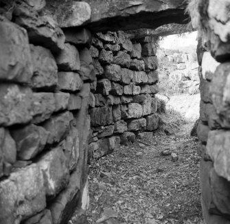
Publication photograph: door check and bar hole, north side of entrance.
© Crown Copyright: HES


SC 1401268
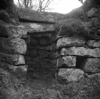
Publication photograph: entrance passage from outside, Torwood Broch.
© Crown Copyright: HES


SC 1401271
Oblique aerial view centred on the remains of the Allt Cosach township, limekiln and homestead, taken from the SW.
© Crown Copyright: HES


DP 172364
Location map showing Litigan and Queens View. Photographic copy of publication drawing from Taylor (1990), fig.1 (received from D B Taylor, 6/11/93)
© Courtesy of HES. Papers of Dr Margaret E C Stewart, archaeologist, Perth, Scotland

DP 172365
General distribution map of circular homesteads. Publication drawing from Taylor (1990), fig.11 (received from D B Taylor, 6/11/93)
© Courtesy of HES. Papers of Dr Margaret E C Stewart, archaeologist, Perth, Scotland

DP 172366
Excavation plan. Publication drawing from Taylor (1990), fig 3 (received from D B Taylor, 1993)
© Courtesy of HES. Papers of Dr Margaret E C Stewart, archaeologist, Perth, Scotland

DP 172383
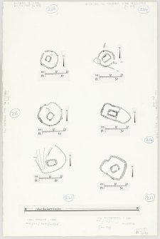
Survey plans of 6 chapels; Cill Mhoire; Cill Eileagain, Mulreesh; Cill Choman; Kilslevan, Cill Slebhan; Duisker; Cill Eathain.
© Crown Copyright: HES


SC 1401440
Publication drawing: Carn Bhiogart enclosure and hut circle. Photographic copy.
© Crown Copyright: HES


SC 337292
Publication drawing: Castle Greg Roman fortlet. [Scan of photographic copy]
© Crown Copyright: HES
SC 721365
Copy of colour slide showing view of Dun Deardail, Glen Nevis, Highland. View of fort from S. ( slopes of Sgor Chalum) 1127ft above sea level NMRS Survey of Private Collection Digital Image Only
© Department of Archaeology, Glasgow University (Helen Nisbet Collection). Courtesy of HES
DP 168163
Plan and section of 'Broch at Dun Voradale' from NE.
© Courtesy of HES (Society of Antiquaries of Scotland Collection)
SC 1364844
Ink drawing of Hut-circle and field system at Druim Mor, Oronsay. Drawn for Argyll Inventory, vol 5.
© Crown Copyright: HES
SC 1367296
Caisteal Grugaig. Inner end of entrance passage, with aperture above the scarcement to right at level of lintel.
© Crown Copyright: HES
DP 170739
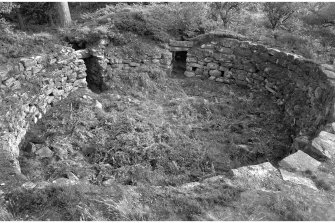
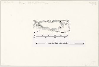
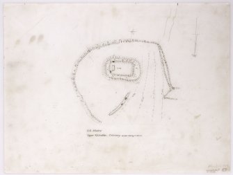
Plane-table survey of interior: Torwood Broch (with 50% reduction in red).
© Crown Copyright: HES
DP 170742
Inked plan of interior: Torwood broch. Photographic copy of STD 42/4.
© Crown Copyright: HES
DP 170743
Plane-table survey of site: Torwood Broch. Photographic copy of STD 42/5.
© Crown Copyright: HES
SC 1367518
Plan and sections of the Vitrified Fort on Craig-Phatric near Inverness. (See also MS/974/1). Photographic copy of drawing.
DP 171696
Survey drawing, Druim An Duin: east elevation of the south entrance (1:20), site section (1:200).
© Crown Copyright: HES
SC 1376598
'Sketch of Craig Patrick by Mr Watt Engineer. Extract from Williams, J 1777 'An Account of some remarkable ancient ruins lately discovered in the highlands and the northern parts of Scotland. [photographic copy only]
DP 171764
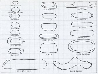
Comparative plans of hillforts with timber-laced walls or ramparts in the NE province from Feachem in Rivet (ed) The Iron Age in N Britain.
SC 1401247
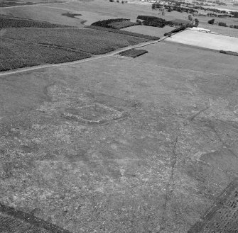
Oblique aerial view of the farmstead, farmsteading, and the the remains of the homestead, taken from the NNE.
© Crown Copyright: HES
SC 1401248
Oblique aerial view centred on the remains of the township, with the remains of the farmsteads, townships, homestead and burial-ground adjacent, taken from the NE.
© Crown Copyright: HES
SC 1401250
Oblique aerial view centred on the remains of the homestead and field-system with the remains of the hut-circle, homestead, building and township, taken from the NE.
© Crown Copyright: HES
SC 1401252
Oblique aerial view centred on the remains of the settlement, field system, possible sheiling-hut and enclosure, with the remains of the structure, field boundaries and possible hut-circle adjacent, taken from the SE.
© Crown Copyright: HES
SC 1401254
Oblique aerial view centred on the remains of the possible homestead with the remains of the farmstead and head-dyke adjacent, taken from the NW.
© Crown Copyright: HES
SC 1401256
Oblique aerial view centred on the remains of the homestead with the remains of the farmsteads adjacent, taken from the W.
© Crown Copyright: HES
SC 1401258
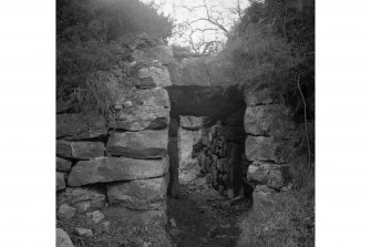
Publication photograph: door check and bar hole, north side of entrance.
© Crown Copyright: HES
SC 1401268
Publication photograph: entrance passage from outside, Torwood Broch.
© Crown Copyright: HES
SC 1401271
Oblique aerial view centred on the remains of the Allt Cosach township, limekiln and homestead, taken from the SW.
© Crown Copyright: HES
DP 172364
Location map showing Litigan and Queens View. Photographic copy of publication drawing from Taylor (1990), fig.1 (received from D B Taylor, 6/11/93)
© Courtesy of HES. Papers of Dr Margaret E C Stewart, archaeologist, Perth, Scotland
DP 172365
General distribution map of circular homesteads. Publication drawing from Taylor (1990), fig.11 (received from D B Taylor, 6/11/93)
© Courtesy of HES. Papers of Dr Margaret E C Stewart, archaeologist, Perth, Scotland
DP 172366
Excavation plan. Publication drawing from Taylor (1990), fig 3 (received from D B Taylor, 1993)
© Courtesy of HES. Papers of Dr Margaret E C Stewart, archaeologist, Perth, Scotland
DP 172383
Survey plans of 6 chapels; Cill Mhoire; Cill Eileagain, Mulreesh; Cill Choman; Kilslevan, Cill Slebhan; Duisker; Cill Eathain.
© Crown Copyright: HES
SC 1401440
Publication drawing: Carn Bhiogart enclosure and hut circle. Photographic copy.
© Crown Copyright: HES
