
World Heritage Sites


02/03/2011
World Heritage Sites are designated by UNESCO as exceptional places of ‘outstanding universal value ... belonging to all the peoples of the world, irrespective of the territory on which they are located’. The spectacular volcanic archipelago of St Kilda was designated Scotland's first World Heritage Site in 1986, with the Roman frontier of the Antonine Wall gaining recognition in 2008.
There are currently five World Heritage Sites in Scotland:
• St Kilda
• Edinburgh Old and New Towns
• Neolithic Orkney
• New Lanark
• The Antonine Wall
Through our active surveying and recording programmes RCAHMS has generated a wealth of imagery relating to these important sites including photographs, aerial views, and digital drawings. RCAHMS also maintains an active digitisation programme of its Collection items, copying photographs and historic views, photograph albums, original architects’ drawings, excavation plans, new survey drawings, engravings, sketches, books and maps.
To mark World Heritage Day, selected examples from our Collections are available to browse and buy below.


SC 347529
Publication drawing: plan of the Roman fort, Balmuildy; after S N Miller
© Crown Copyright: HES

SC 347530
Publication drawing: general plan showing the Roman fort, bridge and temporary camp, Balmuildy.
© Crown Copyright: HES


SC 369050
Early nineteenth century engraved view of New Lanark from South bank of the Clyde showing four mill buildings with housing behind. Insc. 'Lanark Cotton Mills, the property of Robert Owen Esq. and Co.'
© RCAHMS


SC 416592
Publication drawing; St Kilda village, distribution plan of houses dating from 1861 and later. Photographic copy.
© Crown Copyright: HES

SC 416619
St Kilda Village. General view from North West towards bay with steamer at anchor, including Store, School, Church and Manse in distance.
© RCAHMS

SC 436222
Oblique aerial view, taken from the SSW, centred on Moray Place, Edinburgh and with the New Town visible across much of the photograph.
© Crown Copyright: HES

SC 453751
Edinburgh engraving: general view from South with Firth of Forth in background and two men on horse-back in the foreground. Titled: 'Edynburgum'.
© RCAHMS


SC 453755
Armstrong's Map of Lothian. Titled: 'Plan of the City, Castle and Suburbs of Edinburgh'. Engraving. Scale 500':1".
© RCAHMS

SC 453759
View of the New Bridge. Titled: 'A view of the New Bridge of Edinburgh with the adjacent buildings of the Old and New Town from the West'. Engraving.
© RCAHMS

SC 453761
View of Old and New Towns with North Bridge from West. Titled: 'New Town' 'Edinburgh' 'Old Town'.
© RCAHMS


SC 465077
Engraving showing general view of the New Town from the Ramsay Gardens Copied from 'Modern Athens'. Insc. 'Part of the New Town, from Ramsey Gardens, Edinburgh. Drawn by Tho. H Shepherd. Engraved by J Rolph'
© Courtesy of HES. Illustration from Modern Athens, T H Shepherd, 1829

SC 465084
Edinburgh, High Street, St Giles' Cathedral; Lawnmarket, General Engraving showing St Giles' Cathedral looking east from the Lawnmarket Copied from 'Modern Athens'. Insc. 'St. Gile's Church, County Hall, and Lawn Market, High St., Edinburgh. Drawn by Tho. H Shepherd. Engraved by W Tombleson'
© Courtesy of HES. Illustration from Modern Athens, T H Shepherd, 1829


SC 465088
Engraving of North Bridge and Calton Hill from the Mound, Edinburgh. Copied from 'Modern Athens'. Insc. 'North Bridge, Calton Hill, &c. from the Bank of Scotland, Edinburgh. Drawn by Tho. H Shepherd. Engraved by S Lacy'.
© Courtesy of HES. Illustration from Modern Athens, T H Shepherd, 1829

SC 465097
Edinburgh, North Bridge, General; Market Street, Fruit and Vegetable Market; Market Street, Fishmarket Photographic copy of engraving showing general view of vegetable and fish markets below North Bridge. Copied from 'Modern Athens'. Insc. 'Vegetable and Fish Market, from the 'Rainbow' Gallery. Edinburgh. Drawn by Tho. H Shepherd. Engraved by E Stalker'
© Courtesy of HES. Illustration from Modern Athens, T H Shepherd, 1829

SC 465121
Engraving showing general view across Edinburgh looking down from The Castle Copied from 'Scotland Illustrated, Volume 1'. Insc.'Edinburgh from the Castle Ramparts. (with the great gun Mons Meg.) This plate is dedicated to Lt. Colonel Harvey, K.H. of Edinburgh Castle. W.H. Bartlett. H. Griffiths'
© RCAHMS

SC 465130
Engraving showing general view of Edinburgh Castle from the east Copied from 'Maitland's History of Edinburgh'. Insc. 'A Perspective View of the Eastern Side of the Castle. tken in the year 1750. T. Sandby Delin. P. Fourdrinier Sculp.'
© RCAHMS


SC 466234
Engraving of The Mound, Edinburgh showing New College. Titled: 'Mr Trotter of Dreghorns Plan for Improving the Mound'.
© RCAHMS

SC 466310
Plan of New Town. Titled: 'Plan of the New Streets and squares intended for the new city of Edinburgh'. Insc: 'His Most Sacred Majesty, George III, The Munificent Patron of every polite and liberal Art. This Plan of the New Streets and Squares intended for his ancient capital of North Britain; One of the happy consequences of the Peace, Security and Liberty his people enjoy under his mild and auspicious government, is with the utmost humility inscribed by his Majesty's most devoted servant and his subject, James Craig'.
© RCAHMS


SC 512144
Colour lithograph showing general view looking down Lawnmarket from Castlehill. Original insc. "W.L.Leitch, del. T.Picken, Lith. London, Day & Son Glasgow, R.Griffin & Co. Day & Son, Lith.rs to the Queen High Street from Head of West Bow, Lawnmarket"
© RCAHMS


SC 543409
New Lanark Mills and Housing Front elevation and ground and 1st floor plans, site plan Titled: 'Terrace of mill-workers flats - New Lanark' Insc: 'sheet no 4 measured and drawn by BT Danek MK Borland 1945'
© RCAHMS


SC 608102
New Lanark, 5 and 7 Rosedale Street, David Dale's House Elevated view from SE
© HES. Reproduced courtesy of J R Hume

SC 681466
General view from the south west. Original negative captioned 'Stone Circle at Brogar, (Stones of Stennis) Orkney July 1905 / Viewed from South West'.
© Courtesy of HES (Society of Antiquaries of Scotland Collection)

SC 682252
View of two of the Stones of Stenness, then an arable field. A figure serves as scale.
© Courtesy of HES (Society of Antiquaries of Scotland Collection)


SC 696735
New Lanark: view looking SE along lade with Mill Number 3 in background and part of Mill Number 2 on right
© HES. Reproduced courtesy of J R Hume

SC 722682
General oblique aerial view of the Hirta centred on the village and remains of the enclosures, taken from the WSW.
© RCAHMS


SC 754873
New Lanark: detailed view from W of water-wheel pit, which now contains a water wheel acquired from Hole Mill Farm in Fife, from where it was removed and widened in the 1990s
© RCAHMS


SC 754973
New Lanark: view from E of lade as it passes in front of Mill No. 3, with Mills No. 2 and 1 in the distance
© RCAHMS

SC 754989
Elevated view from S (viewed from Mill No. 2), with New Lanark Church of Scotland in the background
© RCAHMS

SC 755007
Oblique view from W of New Lanark Road, with New Buildings in foreground (left), telephone box (right), and the Counting House (Caithness Row) in background
© RCAHMS

SC 755068
New Lanark: general view from N showing Dye Works in the context of the River Clyde
© RCAHMS


SC 755074
New Lanark: view from N of NE and NW sides of the engine house, which is detached from the mill itself (background right), being situated at the NW end of 'The Institute'. Mill No.3 and its engine house are now connected by an overhead walkway
© RCAHMS

SC 755078
New Lanark: interior. View from S within engine house showing steam engine. Similar to the original engine, this is a 250hp twin-tandem compound mill engine by Petrie of Rochdale (1912) re-located from Philiphaugh Mill near Selkirk by the New Lanark Conservation Trust
© RCAHMS

SC 793544
Engraving, insc: "Waterloo Place, the National & Nelson's Monuments, Calton Hill. &c, Edinburgh".
© Courtesy of HES. Illustration from Modern Athens, T H Shepherd, 1829

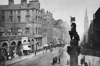
SC 801639
The unicorn atop the Mercat Cross with view from SW of High Street and City Chambers, Edinburgh. 1869 Photo montage.
© RCAHMS


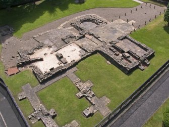
SC 872940
NW oblique aerial view of the excavations at Dullatur Roman Camps, Antonine Wall.
© Crown Copyright: HES

SC 891890
Engraving showing birds' eye view looking over Holyrood Palace Insc. "The Royal Palace of Holyrood House. P. Fourdrinier, sculp." Copied from Maitland's "History of Edinburgh"
© RCAHMS

SC 897088
Feu plan of Edinburgh showing property belonging to George Heriot's Hospital. Scanned image of E 42136 CN.
© HES (Dick Peddie and McKay Collection)

SC 902614
Oblique aerial view of Kinneil fortlet and the Antonine Wall (c. 9800 8052), taken from the SSE.
© Crown Copyright: HES


SC 932545
Engraving showing general view, looking East from the Castle Esplanade with figures standing round cannon. Insc: 'Published by J. Brydone, 29, Princes Street, Edinburgh' 'J Ramage. T Brown'.
© RCAHMS


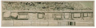
SC 934405
Drawing showing the course of the entire Antonine Wall along with plans and sections of the main forts and fortlets along the Wall. Surveyed in 1755. Titled 'Plan showing the course of the Roman wall called grime's Dyke...together with plans of those stations belonging to the wall'.
© RCAHMS

SC 941153
NNW oblique aerial view of Rough Castle Roman Fort and the Antonine wall.
© Crown Copyright: HES


SC 944663
Ordnance Survey Map of Edinburgh. Coloured 1st edition 'Edinburgh and its Environs', Sheet 35. Includes Edinburgh Castle, St Giles Cathedral, Greyfriars Church, George Heriot's School and Grassmarket.

SC 973449
View of Vere Gordon Childe with a group of workmen during the excavations at Skara Brae in 1930.
© Courtesy of HES (Vere Gordon Childe Collection)


DP 013828
Charlotte Square - Plan of square and eastward to Frederick Street including George Street (plan also shows areas yet to be built on within the New Town)
© RCAHMS

DP 014286
Oblique aerial view centred on the course of the Antonine Wall, taken from the ENE.
© Crown Copyright: HES

DP 014288
Oblique aerial view centred on the remains of Rough Castle Roman fort and the course of the Antonine Wall, taken from the SE.
© Crown Copyright: HES


DP 014297
Oblique aerial view centred on the remains of Rough Castle Roman fort and the course of the Antonine Wall, taken from the S.
© Crown Copyright: HES

DP 018427
Double spread of Edinburgh plan from Kirkwood's Plans and illustrations of the City of Edinburgh
© RCAHMS


DP 021010
Oblique aerial view centred on the site of the Roman fortlet and the course of the Antonine Wall and the Military Way with the canal and aqueduct adjacent, taken from the NE.
© Crown Copyright: HES


DP 021073
Ms G Brown from RCAHMS surveying at Seabegs Wood Roman Fortlet on the Antonine Wall.
© Crown Copyright: HES

DP 026263
Oblique aerial view of Edinburgh's Old Town centred on Victoria Street with the church adjacent, taken from the SE.
© Crown Copyright: HES


SC 1078262
Excavation photograph showing Vere Gordon Childe at Hut 4 Door and cell 2, Skara Brae.
© Courtesy of HES (Vere Gordon Childe Collection)


DP 029280
Map of Edinburgh, with ink annotations. "Edinburgh. Drawn and Engraved for the General Post Office Directory 1840 - 1854." 'MEMORABILIA, JOn. SIME EDINr. 1840' Page 1 verso
© Courtesy of HES (Rev John Sime/The Royal Company of Merchants of the City of Edinburgh Collection)

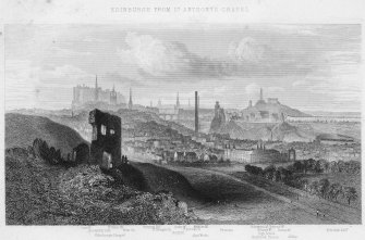
SC 1082783
Historic view of Princes Street, Calton Gaol and Edinburgh Castle, seen from Calton Hill. Insc: 'Edinburgh from Calton Hill, J.Patrick'.
© RCAHMS

DP 033102
View of Edinburgh. Inscr: 'Edinburgh from the Calton Hill. Looking South. Salisbury Crags, Liberton Tower, David Deans' Ho., Canongate church and burying ground, top of High School, Canongate Jail, Clerk St Church, Gas Works, Pentland Hills, Cowgate Church, Infirmary'.
© RCAHMS

DP 033103
View of Edinburgh. Inscr: 'Edinburgh from St Anthony's Chapel. Castle, Assembly Hall, St Giles Church, St Anthony's Chapel, Tron Church, St John's Church, St George's Church, Scott Monument, St Andrew's Church, North Bridge, Gas Works, Prisons, D Stewart's National Monument, Nelson Mt, Burn's Mt, High School, Holyrood Palace and Abbey, North British Rail'.
© RCAHMS


DP 033378
Oblique aerial view centred on Edinburgh's New Town with city adjacent, taken from the N.
© Crown Copyright: HES

SC 1098280
General view of South Bridge elevation of Old College, Edinburgh
© Courtesy of HES (Francis M Chrystal Collection)


DP 038939
Skara Brae: section copied from Petrie 1865-7 SAS 32.
© Courtesy of HES (Society of Antiquaries of Scotland Collection)


DP 043576
Hirta, Village Bay, consumption dyke and cleit. View of cleit 87 from E.
© Crown Copyright: HES

DP 044254
Hirta, Village Bay, House 16. Detail of incised cross (flash with scale).
© Crown Copyright: HES


DP 044780
Hirta, Village Bay. General view from N showing the burial ground and adjacent crofts and cleits.
© Crown Copyright: HES

DP 044781
Hirta, Village Bay. General view from N, including the Ministry of Defence Establishment, with Dun beyond.
© Crown Copyright: HES

DP 044786
Hirta, Village Bay. General view along the Street from NW, including the burial ground, Factor's House, ablutions block and water tanks.
© Crown Copyright: HES

DP 044808
Village Bay, Hirta, St Kilda. General view from N with cleit in foreground, including the Ministry of Defence Establishment, the radar station on Mullach Sgar and Dun beyond.
© Crown Copyright: HES


DP 045691
Hirta, Village Bay. GPS survey in progress with Ian Parker and Angela Gannon from RCAHMS, and Jill Harden from NTS.
© Crown Copyright: HES

SC 1120458
General view of High Street between Canongate and North Bridge, Edinburgh showing no 153 Allan Ramsay's House, The Temperance Hotel, no 143 The Gun'Temperance and The Gun Coffee House.
© RCAHMS

DP 049214
Perspective view of proposed Albert Memorial Keep at Edinburgh Castle, with National Gallery in foreground.
© RCAHMS

DP 049575
Oblique aerial view centred on St Andrew Square, Edinburgh taken from the NW.
© Crown Copyright: HES


DP 055178
Oblique aerial view centred on the mill village New Lanark in the snow, taken from the South-West.
© Crown Copyright: HES

DP 058594
Oblique aerial view centred on the remains of the henge and stone circle at Ring of Brodgar, taken from the SW.
© Crown Copyright: HES

DP 059208
General oblique aerial view centred on the Ring of Brodgar with the Loch of Stenness and Hoy beyond, taken from the N.
© Crown Copyright: HES


DP 059217
Oblique aerial view with Maes Howe in the foreground looking towards the Loch of Harray with the Ring of Brodgar beyond, taken from the NE.
© Crown Copyright: HES

DP 059262
Oblique aerial view of Skara Brae looking along the beach in the Bay of Skaill, taken from the SW.
© Crown Copyright: HES

DP 059850
Oblique aerial view centred on the Barnhouse settlement with the Stones of Stenness adjacent, taken from the NE.
© Crown Copyright: HES


DP 064037
View of Edinburgh, Parliament Square. Engraving of Parliament Square, Edinburgh. 'The Parliament Close and public characters, of Edinburgh, 50 years since'.
© RCAHMS

DP 069235
Sketch of the Ring of Brodgar, from Sketches of Scottish Antiquities by Waller Hugh Paton (1828-1895)
© Courtesy of HES (Waller Hugh Paton Collection)

DP 069239
Sketch of the Stones of Stenness, from Sketches of Scottish Antiquities by Waller Hugh Paton (1828-1895).
© RCAHMS

SC 1163418
Two prints on one negative of Edinburgh Castle, after Elphinstone c.1746: 1 General view from S.E.; 2 General view from E.
© Crown Copyright: HES


DP 073936
View of Hanover Street, Edinburgh and the Royal Institution, now the Royal Scottish Academy. Titled: 'Edinburgh - Hanover Street and Royal Institute'


DP 074543
View of West Bow, Edinburgh. Titled: 'The West Bow'. PHOTOGRAPH ALBUM No.9: MISS FRANK'S PRINCE CHARLIE ALBUM.
© RCAHMS


SC 1165931
Skara Brae Finds Photograph: Bone and stone objects, including mattocks and carved stone objects
© Crown Copyright

SC 1165950
Skara Brae Finds Photograph: Stone artefacts, included carved stone objects, cleaver and beaked tool.
© Crown Copyright


SC 1167305
General view along Princes Street with Scott Monument in centre, also showing trams, awnings on shop fronts and horses and carriages

DP 077218
'Edinburgh-John Knox's House-Canongate Street' PHOTOGRAPH ALBUM NO 109: G.M. Simpson of Australia's Album, 1880, page 40 verso


DP 083286
Oblique aerial view across the Loch of Harray with the Ring of Brodgar in the foreground and Hoy beyond, taken from the NE.
© Crown Copyright: HES


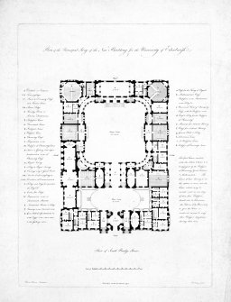
SC 1226438
Engraved plan of Robert Adam's Design for Edinburgh University Original insc. 'Plan of the Principal Story of the New Building for the University of Edinburgh Robert Adam Architect. Published as the Act directs 1791 Harding Sculpt.' Copied from Naismith Edinburgh Album F.32
© Courtesy of HES (Naismith Edinburgh Album)


DP 131656
Ordnance Survey Map of Edinburgh. Coloured 1st edition ' Edinburgh and its Environs', Sheet 35. Includes Edinburgh Castle, St Giles Cathedral, Greyfriars Church, George Heriot's School and Grassmarket.


DP 416576
Ordnance Survey Map of Edinburgh. Coloured 1st edition ' Edinburgh and its Environs', Sheet 23. Includes Canonmills Distillery, Stockbridge, Comely Bank and Edinburgh Academy
SC 347529
Publication drawing: plan of the Roman fort, Balmuildy; after S N Miller
© Crown Copyright: HES
SC 347530
Publication drawing: general plan showing the Roman fort, bridge and temporary camp, Balmuildy.
© Crown Copyright: HES
SC 369050
Early nineteenth century engraved view of New Lanark from South bank of the Clyde showing four mill buildings with housing behind. Insc. 'Lanark Cotton Mills, the property of Robert Owen Esq. and Co.'
© RCAHMS
SC 378264
St Kilda Parliament. Copied from 'An Account of a Trip from Stirling to St Kilda' by David W Logie, 1889. Copied during the RCAHMS survey of St Kilda 1983-6.
© Crown Copyright: HES
SC 416592
Publication drawing; St Kilda village, distribution plan of houses dating from 1861 and later. Photographic copy.
© Crown Copyright: HES
SC 416619
St Kilda Village. General view from North West towards bay with steamer at anchor, including Store, School, Church and Manse in distance.
© RCAHMS
SC 436222
Oblique aerial view, taken from the SSW, centred on Moray Place, Edinburgh and with the New Town visible across much of the photograph.
© Crown Copyright: HES
SC 453751
Edinburgh engraving: general view from South with Firth of Forth in background and two men on horse-back in the foreground. Titled: 'Edynburgum'.
© RCAHMS
SC 453755
Armstrong's Map of Lothian. Titled: 'Plan of the City, Castle and Suburbs of Edinburgh'. Engraving. Scale 500':1".
© RCAHMS
SC 453759
View of the New Bridge. Titled: 'A view of the New Bridge of Edinburgh with the adjacent buildings of the Old and New Town from the West'. Engraving.
© RCAHMS
SC 453761
View of Old and New Towns with North Bridge from West. Titled: 'New Town' 'Edinburgh' 'Old Town'.
© RCAHMS
SC 465077
Engraving showing general view of the New Town from the Ramsay Gardens Copied from 'Modern Athens'. Insc. 'Part of the New Town, from Ramsey Gardens, Edinburgh. Drawn by Tho. H Shepherd. Engraved by J Rolph'
© Courtesy of HES. Illustration from Modern Athens, T H Shepherd, 1829
SC 465084
Edinburgh, High Street, St Giles' Cathedral; Lawnmarket, General Engraving showing St Giles' Cathedral looking east from the Lawnmarket Copied from 'Modern Athens'. Insc. 'St. Gile's Church, County Hall, and Lawn Market, High St., Edinburgh. Drawn by Tho. H Shepherd. Engraved by W Tombleson'
© Courtesy of HES. Illustration from Modern Athens, T H Shepherd, 1829
SC 465088
Engraving of North Bridge and Calton Hill from the Mound, Edinburgh. Copied from 'Modern Athens'. Insc. 'North Bridge, Calton Hill, &c. from the Bank of Scotland, Edinburgh. Drawn by Tho. H Shepherd. Engraved by S Lacy'.
© Courtesy of HES. Illustration from Modern Athens, T H Shepherd, 1829
SC 465097
Edinburgh, North Bridge, General; Market Street, Fruit and Vegetable Market; Market Street, Fishmarket Photographic copy of engraving showing general view of vegetable and fish markets below North Bridge. Copied from 'Modern Athens'. Insc. 'Vegetable and Fish Market, from the 'Rainbow' Gallery. Edinburgh. Drawn by Tho. H Shepherd. Engraved by E Stalker'
© Courtesy of HES. Illustration from Modern Athens, T H Shepherd, 1829
SC 465121
Engraving showing general view across Edinburgh looking down from The Castle Copied from 'Scotland Illustrated, Volume 1'. Insc.'Edinburgh from the Castle Ramparts. (with the great gun Mons Meg.) This plate is dedicated to Lt. Colonel Harvey, K.H. of Edinburgh Castle. W.H. Bartlett. H. Griffiths'
© RCAHMS
SC 465130
Engraving showing general view of Edinburgh Castle from the east Copied from 'Maitland's History of Edinburgh'. Insc. 'A Perspective View of the Eastern Side of the Castle. tken in the year 1750. T. Sandby Delin. P. Fourdrinier Sculp.'
© RCAHMS
SC 466234
Engraving of The Mound, Edinburgh showing New College. Titled: 'Mr Trotter of Dreghorns Plan for Improving the Mound'.
© RCAHMS
SC 466310
Plan of New Town. Titled: 'Plan of the New Streets and squares intended for the new city of Edinburgh'. Insc: 'His Most Sacred Majesty, George III, The Munificent Patron of every polite and liberal Art. This Plan of the New Streets and Squares intended for his ancient capital of North Britain; One of the happy consequences of the Peace, Security and Liberty his people enjoy under his mild and auspicious government, is with the utmost humility inscribed by his Majesty's most devoted servant and his subject, James Craig'.
© RCAHMS
SC 512144
Colour lithograph showing general view looking down Lawnmarket from Castlehill. Original insc. "W.L.Leitch, del. T.Picken, Lith. London, Day & Son Glasgow, R.Griffin & Co. Day & Son, Lith.rs to the Queen High Street from Head of West Bow, Lawnmarket"
© RCAHMS
SC 543409
New Lanark Mills and Housing Front elevation and ground and 1st floor plans, site plan Titled: 'Terrace of mill-workers flats - New Lanark' Insc: 'sheet no 4 measured and drawn by BT Danek MK Borland 1945'
© RCAHMS
SC 608102
New Lanark, 5 and 7 Rosedale Street, David Dale's House Elevated view from SE
© HES. Reproduced courtesy of J R Hume
SC 681466
General view from the south west. Original negative captioned 'Stone Circle at Brogar, (Stones of Stennis) Orkney July 1905 / Viewed from South West'.
© Courtesy of HES (Society of Antiquaries of Scotland Collection)
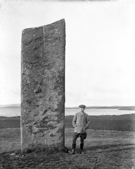
SC 682252
View of two of the Stones of Stenness, then an arable field. A figure serves as scale.
© Courtesy of HES (Society of Antiquaries of Scotland Collection)
SC 696735
New Lanark: view looking SE along lade with Mill Number 3 in background and part of Mill Number 2 on right
© HES. Reproduced courtesy of J R Hume
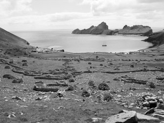
SC 722682
General oblique aerial view of the Hirta centred on the village and remains of the enclosures, taken from the WSW.
© RCAHMS
SC 754873
New Lanark: detailed view from W of water-wheel pit, which now contains a water wheel acquired from Hole Mill Farm in Fife, from where it was removed and widened in the 1990s
© RCAHMS
SC 754973
New Lanark: view from E of lade as it passes in front of Mill No. 3, with Mills No. 2 and 1 in the distance
© RCAHMS
SC 754989
Elevated view from S (viewed from Mill No. 2), with New Lanark Church of Scotland in the background
© RCAHMS
SC 755007
Oblique view from W of New Lanark Road, with New Buildings in foreground (left), telephone box (right), and the Counting House (Caithness Row) in background
© RCAHMS
SC 755068
New Lanark: general view from N showing Dye Works in the context of the River Clyde
© RCAHMS
SC 755074
New Lanark: view from N of NE and NW sides of the engine house, which is detached from the mill itself (background right), being situated at the NW end of 'The Institute'. Mill No.3 and its engine house are now connected by an overhead walkway
© RCAHMS
SC 755078
New Lanark: interior. View from S within engine house showing steam engine. Similar to the original engine, this is a 250hp twin-tandem compound mill engine by Petrie of Rochdale (1912) re-located from Philiphaugh Mill near Selkirk by the New Lanark Conservation Trust
© RCAHMS
SC 793544
Engraving, insc: "Waterloo Place, the National & Nelson's Monuments, Calton Hill. &c, Edinburgh".
© Courtesy of HES. Illustration from Modern Athens, T H Shepherd, 1829
SC 801639
The unicorn atop the Mercat Cross with view from SW of High Street and City Chambers, Edinburgh. 1869 Photo montage.
© RCAHMS
SC 872940
NW oblique aerial view of the excavations at Dullatur Roman Camps, Antonine Wall.
© Crown Copyright: HES
SC 891890
Engraving showing birds' eye view looking over Holyrood Palace Insc. "The Royal Palace of Holyrood House. P. Fourdrinier, sculp." Copied from Maitland's "History of Edinburgh"
© RCAHMS
SC 897088
Feu plan of Edinburgh showing property belonging to George Heriot's Hospital. Scanned image of E 42136 CN.
© HES (Dick Peddie and McKay Collection)
SC 902614
Oblique aerial view of Kinneil fortlet and the Antonine Wall (c. 9800 8052), taken from the SSE.
© Crown Copyright: HES
SC 932545
Engraving showing general view, looking East from the Castle Esplanade with figures standing round cannon. Insc: 'Published by J. Brydone, 29, Princes Street, Edinburgh' 'J Ramage. T Brown'.
© RCAHMS
SC 934405
Drawing showing the course of the entire Antonine Wall along with plans and sections of the main forts and fortlets along the Wall. Surveyed in 1755. Titled 'Plan showing the course of the Roman wall called grime's Dyke...together with plans of those stations belonging to the wall'.
© RCAHMS
SC 941153
NNW oblique aerial view of Rough Castle Roman Fort and the Antonine wall.
© Crown Copyright: HES
SC 944663
Ordnance Survey Map of Edinburgh. Coloured 1st edition 'Edinburgh and its Environs', Sheet 35. Includes Edinburgh Castle, St Giles Cathedral, Greyfriars Church, George Heriot's School and Grassmarket.
SC 973449
View of Vere Gordon Childe with a group of workmen during the excavations at Skara Brae in 1930.
© Courtesy of HES (Vere Gordon Childe Collection)
DP 013828
Charlotte Square - Plan of square and eastward to Frederick Street including George Street (plan also shows areas yet to be built on within the New Town)
© RCAHMS
DP 014286
Oblique aerial view centred on the course of the Antonine Wall, taken from the ENE.
© Crown Copyright: HES
DP 014288
Oblique aerial view centred on the remains of Rough Castle Roman fort and the course of the Antonine Wall, taken from the SE.
© Crown Copyright: HES
DP 014297
Oblique aerial view centred on the remains of Rough Castle Roman fort and the course of the Antonine Wall, taken from the S.
© Crown Copyright: HES
DP 018427
Double spread of Edinburgh plan from Kirkwood's Plans and illustrations of the City of Edinburgh
© RCAHMS
DP 021010
Oblique aerial view centred on the site of the Roman fortlet and the course of the Antonine Wall and the Military Way with the canal and aqueduct adjacent, taken from the NE.
© Crown Copyright: HES
DP 021073
Ms G Brown from RCAHMS surveying at Seabegs Wood Roman Fortlet on the Antonine Wall.
© Crown Copyright: HES
DP 026263
Oblique aerial view of Edinburgh's Old Town centred on Victoria Street with the church adjacent, taken from the SE.
© Crown Copyright: HES
SC 1078262
Excavation photograph showing Vere Gordon Childe at Hut 4 Door and cell 2, Skara Brae.
© Courtesy of HES (Vere Gordon Childe Collection)
DP 029280
Map of Edinburgh, with ink annotations. "Edinburgh. Drawn and Engraved for the General Post Office Directory 1840 - 1854." 'MEMORABILIA, JOn. SIME EDINr. 1840' Page 1 verso
© Courtesy of HES (Rev John Sime/The Royal Company of Merchants of the City of Edinburgh Collection)
SC 1082783
Historic view of Princes Street, Calton Gaol and Edinburgh Castle, seen from Calton Hill. Insc: 'Edinburgh from Calton Hill, J.Patrick'.
© RCAHMS
DP 033102
View of Edinburgh. Inscr: 'Edinburgh from the Calton Hill. Looking South. Salisbury Crags, Liberton Tower, David Deans' Ho., Canongate church and burying ground, top of High School, Canongate Jail, Clerk St Church, Gas Works, Pentland Hills, Cowgate Church, Infirmary'.
© RCAHMS
DP 033103
View of Edinburgh. Inscr: 'Edinburgh from St Anthony's Chapel. Castle, Assembly Hall, St Giles Church, St Anthony's Chapel, Tron Church, St John's Church, St George's Church, Scott Monument, St Andrew's Church, North Bridge, Gas Works, Prisons, D Stewart's National Monument, Nelson Mt, Burn's Mt, High School, Holyrood Palace and Abbey, North British Rail'.
© RCAHMS
DP 033378
Oblique aerial view centred on Edinburgh's New Town with city adjacent, taken from the N.
© Crown Copyright: HES
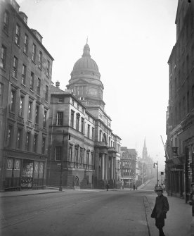
SC 1098280
General view of South Bridge elevation of Old College, Edinburgh
© Courtesy of HES (Francis M Chrystal Collection)
DP 038939
Skara Brae: section copied from Petrie 1865-7 SAS 32.
© Courtesy of HES (Society of Antiquaries of Scotland Collection)
DP 043576
Hirta, Village Bay, consumption dyke and cleit. View of cleit 87 from E.
© Crown Copyright: HES
DP 044254
Hirta, Village Bay, House 16. Detail of incised cross (flash with scale).
© Crown Copyright: HES
DP 044780
Hirta, Village Bay. General view from N showing the burial ground and adjacent crofts and cleits.
© Crown Copyright: HES
DP 044781
Hirta, Village Bay. General view from N, including the Ministry of Defence Establishment, with Dun beyond.
© Crown Copyright: HES
DP 044786
Hirta, Village Bay. General view along the Street from NW, including the burial ground, Factor's House, ablutions block and water tanks.
© Crown Copyright: HES
DP 044808
Village Bay, Hirta, St Kilda. General view from N with cleit in foreground, including the Ministry of Defence Establishment, the radar station on Mullach Sgar and Dun beyond.
© Crown Copyright: HES
DP 045691
Hirta, Village Bay. GPS survey in progress with Ian Parker and Angela Gannon from RCAHMS, and Jill Harden from NTS.
© Crown Copyright: HES
SC 1120458
General view of High Street between Canongate and North Bridge, Edinburgh showing no 153 Allan Ramsay's House, The Temperance Hotel, no 143 The Gun'Temperance and The Gun Coffee House.
© RCAHMS
DP 049214
Perspective view of proposed Albert Memorial Keep at Edinburgh Castle, with National Gallery in foreground.
© RCAHMS
DP 049575
Oblique aerial view centred on St Andrew Square, Edinburgh taken from the NW.
© Crown Copyright: HES
DP 055178
Oblique aerial view centred on the mill village New Lanark in the snow, taken from the South-West.
© Crown Copyright: HES
DP 058594
Oblique aerial view centred on the remains of the henge and stone circle at Ring of Brodgar, taken from the SW.
© Crown Copyright: HES
DP 059208
General oblique aerial view centred on the Ring of Brodgar with the Loch of Stenness and Hoy beyond, taken from the N.
© Crown Copyright: HES
DP 059217
Oblique aerial view with Maes Howe in the foreground looking towards the Loch of Harray with the Ring of Brodgar beyond, taken from the NE.
© Crown Copyright: HES
DP 059262
Oblique aerial view of Skara Brae looking along the beach in the Bay of Skaill, taken from the SW.
© Crown Copyright: HES
DP 059850
Oblique aerial view centred on the Barnhouse settlement with the Stones of Stenness adjacent, taken from the NE.
© Crown Copyright: HES
DP 064037
View of Edinburgh, Parliament Square. Engraving of Parliament Square, Edinburgh. 'The Parliament Close and public characters, of Edinburgh, 50 years since'.
© RCAHMS
DP 069235
Sketch of the Ring of Brodgar, from Sketches of Scottish Antiquities by Waller Hugh Paton (1828-1895)
© Courtesy of HES (Waller Hugh Paton Collection)
DP 069239
Sketch of the Stones of Stenness, from Sketches of Scottish Antiquities by Waller Hugh Paton (1828-1895).
© RCAHMS
SC 1163418
Two prints on one negative of Edinburgh Castle, after Elphinstone c.1746: 1 General view from S.E.; 2 General view from E.
© Crown Copyright: HES
DP 073936
View of Hanover Street, Edinburgh and the Royal Institution, now the Royal Scottish Academy. Titled: 'Edinburgh - Hanover Street and Royal Institute'
DP 074543
View of West Bow, Edinburgh. Titled: 'The West Bow'. PHOTOGRAPH ALBUM No.9: MISS FRANK'S PRINCE CHARLIE ALBUM.
© RCAHMS
SC 1165931
Skara Brae Finds Photograph: Bone and stone objects, including mattocks and carved stone objects
© Crown Copyright
SC 1165950
Skara Brae Finds Photograph: Stone artefacts, included carved stone objects, cleaver and beaked tool.
© Crown Copyright
SC 1167305
General view along Princes Street with Scott Monument in centre, also showing trams, awnings on shop fronts and horses and carriages
DP 077218
'Edinburgh-John Knox's House-Canongate Street' PHOTOGRAPH ALBUM NO 109: G.M. Simpson of Australia's Album, 1880, page 40 verso
DP 083286
Oblique aerial view across the Loch of Harray with the Ring of Brodgar in the foreground and Hoy beyond, taken from the NE.
© Crown Copyright: HES
SC 1226438
Engraved plan of Robert Adam's Design for Edinburgh University Original insc. 'Plan of the Principal Story of the New Building for the University of Edinburgh Robert Adam Architect. Published as the Act directs 1791 Harding Sculpt.' Copied from Naismith Edinburgh Album F.32
© Courtesy of HES (Naismith Edinburgh Album)
DP 131656
Ordnance Survey Map of Edinburgh. Coloured 1st edition ' Edinburgh and its Environs', Sheet 35. Includes Edinburgh Castle, St Giles Cathedral, Greyfriars Church, George Heriot's School and Grassmarket.
DP 416576
Ordnance Survey Map of Edinburgh. Coloured 1st edition ' Edinburgh and its Environs', Sheet 23. Includes Canonmills Distillery, Stockbridge, Comely Bank and Edinburgh Academy
