Measured Survey


Date 12 May 2014 - 15 May 2014
Event ID 996505
Category Recording
Type Measured Survey
Permalink http://canmore.org.uk/event/996505
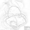
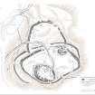
The fort on the summit of Moredun Top, Moncreiffe Hill, sometimes also referred to as Carnac, was surveyed by RCAHMS in May 2014. This note serves as a summary of the full site description which is available as a PDF (RCAHMS WP 003618). The drawn survey is available online as both the original drawing (SC 1425572) and as a final illustration (DP 203195 or WP 003616).
On the basis of field survey, the site comprises the following elements:
(A) A large mound, possibly a cairn, which stands within the E side of the interior and appears to comprise a grass-grown mass of loose stone measuring about 30m from E to W by 23m transversely and at least 1.5m in height.
(B) An oval enclosure measuring about 197m from ENE to WSW by 100m transversely (c1.5ha) within the remains of a thick stone wall.
(C) A second phase of fortification is represented by a sub-oval enclosure measuring about 170m from E to W by 103m transversely (1.15ha) within the remains of a thick stone wall
(D) Possibly in use contemporarily with the second phase enclosure is the large enclosure which appears to have been attached to its N side. This enclosure, which is roughly D-shaped on plan - the chord of the D formed by the wall of the second phase enclosure, measures 110m from E to W by 76m transversely, again within the remains of a thick wall.
(E) The third phase of enclosure is a comparatively small but very thick-walled fort that crowns the highest part of the hill. Oval on plan, it measures about 53m from NW to SE by 38m transversely within a wall reduced to a stony bank up to 13m in thickness but no more than 1m in internal height.
(F) A phase of unenclosed settlement on the summit is represented by four hut-circles – three lying within the small summit fort and one immediately to the north.
In addition to these principal components, there is extensive evidence of quarrying – in the form of excavations into the solid bedrock and as shallower pits which have seen the removal of what is effectively loose rubble from archaeological features. Moreover, there is sufficient evidence in the form of trenching to demonstrate antiquarian investigation of the fort.
Visited by RCAHMS (GFG, JRS, IP), 12-15 May 2014.