Field Visit


Date 25 June 1943
Event ID 978690
Category Recording
Type Field Visit
Permalink http://canmore.org.uk/event/978690
Mote, Carnwath.
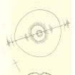
Carnwath Mote stands just outside the W outskirts of the village, N of the Glasgow road. It consists of a truncated cone of sandy earth mixed with small stones, surrounded at its base by a ditch. The whole monument has been planted with trees.
The outline of the base, where it rises from the bottom of the ditch was established by means of a compass traverse, and appears on the plan (q.v.) as approximating fairly closely to a circle; the ‘diameter’ varies from 130 to 140 ft. The ditch is from 10ft to 12 ft wide at the bottom, and this, with the counterscarp of the ditch, gives a total diameter of 183 ft for the whole monument along the line of the section (q.v) which runs from just N of W to just S of E. There is now no sign of any mound on the counterscarp of the ditch, and it has no doubt been destroyed since the end of the 18th century (c.f. Stat. Acct., x, 335). The lower slopes of the mote-hill are very steep, 35° on the E and 36° on the W; but towards the top the gradient decreases noticeably. The summit-area if flat, oval in outline, and measures 47ft from N to S by 39ft from E to W. Near the centre is the hollow at the bottom of which it is recorded that a stair could once be seen descending into the mound (c.f. PSAS, xxiv, 288 and Stat. Acct. loc. cit.). The summit is 32ft above the bottom of the ditch on the W and 28ft above it on the E; the ground slopes naturally from E to W, but the greater depth of the ditch on the E side – 5ft 6ins as compared with 2ft on the W – goes some way towards equalizing those measurements (Photos).
Some damage has recently been done to the outer lip of the ditch by the digging of deep slit-trenches.
Visited by RCAHMS 25 June 1943.
OS map ref: xxvi NE