RCAHMS - GENERAL Recording Event


Date 16 October 2013 - 16 October 2013
Event ID 974196
Category Recording
Type Field Visit
Permalink http://canmore.org.uk/event/974196
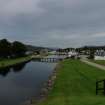
Corpach Basin. NN07NE 9.06
This basin is aligned roughly E-W and is c200m in length by 50m in width. On the north bank a stone quay extends for the whole length; it has a landing stage and a large car park. The south side of the basin is retained by a substantial grassy raised embankment which is stone pitched at water level. The embankment is 2m in height and c12m in width and has a footpath and a number of bollards along its length; on its south, seaward side a short stretch of masonry, 1m height x 2m length, part of a building marked on FES, is seen at GR NN 9724 76607. To the west evidence of a retaining wall is seen.
Information from Scottish Canals Recording Project (MM), 2013