Field Visit


Date 15 May 1915
Event ID 959578
Category Recording
Type Field Visit
Permalink http://canmore.org.uk/event/959578
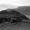
Dun, Kraiknish, Loch Eynort.
On an elevated rock , rising about 50 feet above the water, on the southern side of the mouth of Loch Eynort, about 1 mile west of Kraiknish, is a ruined dun. On the flanks the rock has a height of about 25 feet, and on the landward side towards the south-east it is about 15 feet high, and is approached by a steep slope. The defences consist of a stone wall built on the edge of the rock, and an outer wall built on the slope towards the land with its ends resting on the rocks on the flanks. The inner wall , enclosing a rounded triangular space, measuring some 56 feet from north-east to south-west, and some 52 feet from north-west to south-east internally, has almost disappeared on the sides next to the sea, but on the landward side it shows the inner face rising about 4 feet above the interior, and the outer face standing to a height of 7 feet on the south, the remaining section being for the greater part hidden by tumbled stones. At its widest part it is 10 feet 9 inches thick, but it attenuates as it curves back and merges into the side walls. The outer face of the outer wall, showing 3 feet of building at most in position, stands 19 feet from, and apparently about 8 feet lower than, the inner wall. The roadway into the dun lies towards the southern end of the outer wall, which recurves inwards at the entrance. The wall on the left side is broken down , but the entrance seems to have been about 4 feet wide. The roadway slants to the left and enters the enceinte through an inner entrance, also broken down, about 4 feet 4 inches in width.
Visited by RCAHMS (JGC) 15 May 1915.
OS Map: Skye xliii (unnoted) .