Field Visit


Date 19 March 1955
Event ID 926061
Category Recording
Type Field Visit
Permalink http://canmore.org.uk/event/926061
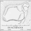
Fort, Duncarnock.
Duncarnock is a conspicuous rocky eminence which forms the NE end of a broad ridge situated in undulating country two miles S of Barrhead. The N part of the hill is capped by a craggy and inhospitable knoll rising to a height of 668 feet OD, while the S part consists of an extensive rock-strewn plateau the general level of which is some 30 feet less than that attained by the knoll. These two features are connected by a saddle, the central part of which, measuring about 45 feet in both length and breadth, is level with the plateau. From this, narrow sloping valleys fall away to NW and SE, accentuating the separation of the other two features. To W, NW, N and NE the rocky flanks of the hill rise very steeply to a height of about 100 feet above the land below, and to S a steep grassy slope rises about 40 feet from the spine of the ridge to the summit plateau. For a short distance to the N of the crest of this slope there is a minor descent to the general level of the summit plateau, the S end of which is thus marked by a slight knoll. The SE flank of the hill falls only gradually to merge with the slope which forms part of the W side of the valley of the Brock Burn.
The fort [DP 148822] occupies the whole of the top of the hill, the area enclosed by a ruinous drystone wall measuring about 630 feet in length by about 330 feet in breadth. For parts of its length the wall is represented only by the natural line of the crest of the steep flank of the hill, with only an infrequent earthfast boulder to indicate the line. Such is the stretch at the N extremity of the fort, but in the adjacent NE sector, the wall appears as a low stony mound 8 feet to 10 feet in width. This runs for a distance of 50 feet southwards up to the crestline of the highest part of' the knoll, an uneven sub-oval area measuring about 100 feet in length by 80 feet in breadth and flanked by low rocky escarpment. Traces of the wal1 then disappear, but it must have run S and SSE as recognisable remains again appear at a point 200 feet further on. Here, near the SE extremity of a tapering spine of rock which protrudes SE from the knoll, a row of large earthfast boulders must represent the remains of the foundation course of the inner face of the wall. After about 25 feet this row is joined at a distance of 9 feet on its E or outer side by a row of similar boulders representing the grounders of the outer face. The two rows run for 25 feet to the tip of the tapering spine, and where this joins the SE valley of the saddle the inner row ceases. The outer row can however be followed across the 10 feet gap which lies between the tip of the spine and the beginning of a substantial incline which represents the next stretch of the wall. The gap is probably-the entrance to the fort, and the fact that the foundation of the outer face of the wall runs across suggests that that might have been a doorway or portal in the wall at this point.
The mound, about 15 feet in width and up to 3 feet 6 inches in height, runs S from the entrance for a distance of 60 feet along which no trace of the inner face of the wall and only one stone of the outer face appear. From there outwards, however, for a distance of about 400 feet the lowest courses of the outer face are visible almost continuously. This seems likely to be the result of the clearance of the face of the wall to facilitate the removal of all but the grounders and firm foundation stones, probably in a search for material for build field boundaries. For a distance of about 300 feet the mound continues to appear behind the exposed outer face. It is irregular in size, and its appearance may be a further result of the quarrying. After reaching this point the mound dies away and the cleared face of the wall runs for a distance of about 100 feet round the S face of the slight knoll which occupies the S end of the summit plateau. The line of clearance then ceases, at a point where the slope is very steep. The wall probably ran thence up over the W end of the knoll and on to the of the W flank of the summit plateau where it reappears at a distance of 90 feet NW of the end of the cleared face. Part of the gap is due to the presence of an earthen bank with of a slight ditch on its N. side which crosses the S extremity of the fort from WNW to SSE. The clearance of the outer face of the fort wall was carried out at a later date than that of the construction of the bank, as the cleared face runs right through this.
From its point of reappearance, the wall runs NNW, N and NE round the natural crest of the flank of the hill, appearing as an intermittent stony mound with a few conspicuous earthfast boulders. It crosses the NW end of the NW alley of the saddle, and re-joins the summit knoll.
The summit knoll is thus defended by the fort wall on all sides except the SW where it adjoins the saddle. There is evidence that this side has also defended, as a line earthfast boulders runs up the NE side of the NW valley of the saddle at a distance of about 10 feet from the bottom of the steep rocky SW face of the knoll. It starts a few yards from the fort wall and runs for 135 feet to end on the middle of the saddle. Another line overlapping the former by 10 feet, stands right against the foot of the face of the knoll and runs ESE. along it for 65 feet where it ends at a gully which presumably represents a way up to the knoll. Beyond this point the line is taken up by the foot of the tapering rocky spine which ends at the NE side of the fort entrance. It is thus possible that the knoll was designed as a stronghold of defence; it might have had further walls along the margins of the higher terraces and the sub-oval summit area referred to above.
Among the numerous large boulders which are abundantly strewn over much of the site are some which appear to lie in some order. One such group, forming an L-shaped line, lies at the head of the SE valley of the saddle. The area outside the SSE. stretch of the fort wall contains a great many boulders, some of which may have formed parts of walls or settings. The line of one such is shown on the plan above the slope which leads down to the external line of entrance to the fort. A distinct line of set stones does appear, however, protruding through the turf for a length of about 170 feet at a distance of about 15 feet outside the line of the cleared face of the SE part of the fort wall. The function of this line is obscure; it might represent part of a reinforcement of the defences at this point where the line of approach to the fort is the least difficult.
The fort is one of the principal monuments of its kind in the district, and its character suggests that it may be of Dark Age date.
Visited by RCAHMS (RWF) 19 March 1955.