Field Visit


Date 15 August 1956
Event ID 919991
Category Recording
Type Field Visit
Permalink http://canmore.org.uk/event/919991
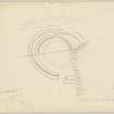
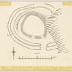
Fort, Maiden Castle, Pittodrie.
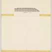
This fort stands at a height of 690 feet OD 550 yards NW of Pittodrie House on a broad, level tongue to north and east of which irregular rocky slopes fall away to the easier ground 70 feet or 80 feet below, while to the west uneven wooded land descends more gently towards Boghead farmhouse. The structure consists of a stone wall within a rampart and ditch, the wall enclosing an oval area which measures 80 feet in length from south east to north west by 65 feet transversely. Only a low mound of stones about 12 feet in width now represents the wall, and no facing stones could be seen. The entrance is in the south, a modern break occurring some 10 yards west of it. The wall was built on a slight elevation and the rampart and ditch lie at the foot of this. The former consists of a low rubble mound which, where best preserved, in the west, attains to a height of 1 foot 7 inches above the level of the base of the elevation upon which the wall stands and to 5 feet 6 inches above the bottom of the ditch which here lies 3 feet below the surface of the ground outside. The rampart and ditch each measure 12 feet in width.
The bay in the crest of the steep east flank of the site interrupts the line of the rampart and ditch, and there is nothing to show whether this was originally the case or whether the gap is due to land slip. There is, however, also a gap 60 feet in length in the NE arc of the rampart although the outer ditch is continuous. The entrance in the outer works conforms to that of the wall. The interior is planted with trees and contains no recognisable features.
Visited by RCAHMS (RWF) 15 August 1956.