
Field Visit


Date 15 May 2010 - 17 May 2010
Event ID 634516
Category Recording
Type Field Visit
Permalink http://canmore.org.uk/event/634516
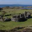
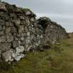
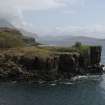
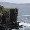
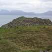
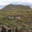
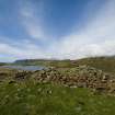
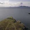
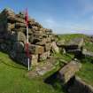
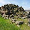
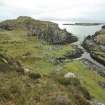
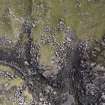
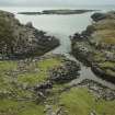
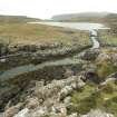
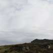
NG 3959 1595 The work on the peninsula, begun in 2009 (DES 2009, 92–93), continued on 15–17 May 2010 with a survey of the galleried dun. The 30m curving wall, in places up to 5m high, bounds a precipitous rocky headland now c225sqm in extent. On all three exposed sides there is evidence of major rockfalls on the foreshore below, while both E and W ends are disintegrating over the edge. The extent to which these processes have diminished the structure and the promontory beyond is unquantifiable but probably considerable. In view of its massive monumental architecture and the probability that the enclosed area was significantly greater than it is today, it is suggested that the monument is best categorised not as a ‘dun’ but as a ‘headland fort’.
Further examination of the adjacent canal feature revealed a distinctive change of build in the W revetment about half-way along its length, at NG 3945 1600. The seaward sector is built of long slabs laid horizontally while the upper sector leading into the loch is of smaller rounded rubble. This suggests two phases, the first linking the two boat nausts below the fort to the sea and the second continuing the canal into the loch. Although the stones of the fort wall are similar to those of the lower canal revetment, they do not appear to have been robbed. This suggests either that the fort, lower canal, and nausts are contemporary, or (perhaps more probably) that when the latter two features were built an already existing fort was retained as part of the overall scheme. A terminus post quem for the upper canal is provided by a boat timber from the loch which has been radiocarbon dated to AD c1100.
Archive: RCAHMS (intended)
Funder: Morvern Maritime Centre
Colin Martin and Paula Martin – Morvern Maritime Centre
Ordnance Survey licence number AC0000807262. All rights reserved.
Canmore Disclaimer.
© Copyright and database right 2024.

DP 175294
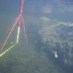
Aerial photograph of the Rubh’ an Dùnain peninsula from the W, with the Cuillin Hills rising in the background. Loch na h-Airde is close to the tip of the peninsula. Loch Brittle is on the left, with Glenbrittle at its head. (Edward Martin)
Dr Colin and Dr Paula Martin
2008
© Courtesy of HES (Dr Colin and Dr Paula Martin Collection)

DP 175295
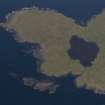
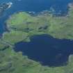
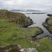
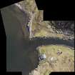
Aerial photograph of the W tip of the Rubh an Dùnain peninsula showing Loch na h-Airde and the canal linking it to the sea. The islet of Sgeir Mhòr provides a sheltered anchorage beyond the canal's mouth. (Colin Martin)
Dr Colin and Dr Paula Martin
2008
© Courtesy of HES (Dr Colin and Dr Paula Martin Collection)

DP 175296
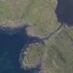
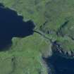
Aerial photograph of the headland fort and canal from the SE. Underwater indications of a stone-built quay can be seen on either side of the canal’s entry to the loch. Beyond the canal entrance a basin of deeper water largely clear of weed is visible. (Colin Martin)
Dr Colin and Dr Paula Martin
2008
© Courtesy of HES (Dr Colin and Dr Paula Martin Collection)

DP 175297
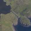
Aerial photograph of the headland fort and canal from the SW. Underwater indications of a stone-built quay can be seen on either side of the canal’s entry to the loch. Beyond the canal entrance a basin of deeper water largely clear of weed is visible. (Colin Martin)
Dr Colin and Dr Paula Martin
2008
© Courtesy of HES (Dr Colin and Dr Paula Martin Collection)

DP 175298
Aerial photograph of the headland fort, canal, and loch from the S. (Colin Martin)
Dr Colin and Dr Paula Martin
2008
© Courtesy of HES (Dr Colin and Dr Paula Martin Collection)

DP 175299
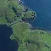
Aerial photograph of Loch na h-Airde from the NE, showing the canal, headland fort (extreme centre left) and the sheltered anchorage afforded by Sgeir Mhòr (top left). (Colin Martin)
Dr Colin and Dr Paula Martin
2008
© Courtesy of HES (Dr Colin and Dr Paula Martin Collection)

DP 175300
Aerial photograph of the canal and headland fort from the NW. The cleared channel towards the mouth of the canal is evident. (Colin Martin)
Dr Colin and Dr Paula Martin
2008
© Courtesy of HES (Dr Colin and Dr Paula Martin Collection)

DP 175301
Aerial photograph of the canal and headland fort from the SW. The cleared channel towards the mouth of the canal is evident. (Colin Martin)
Dr Colin and Dr Paula Martin
2008
© Courtesy of HES (Dr Colin and Dr Paula Martin Collection)

DP 175302
Loch na h-Airde from the settlement above Rubh’ an Dùnain, looking SW.
Dr Colin and Dr Paula Martin
2008
© Courtesy of HES (Dr Colin and Dr Paula Martin Collection)

DP 175303
Loch na h-Airde from the settlement above Rubh’ an Dùnain, looking SW. The so-called ‘Tacksman’s House’ is in the foreground. (Colin Martin)
Dr Colin and Dr Paula Martin
2008
© Courtesy of HES (Dr Colin and Dr Paula Martin Collection)

DP 175304
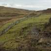
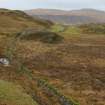
The Slochd Dubh – Black Dyke – a stone wall running from one side of the Rubh’ an Dùnain peninsula to the other, evidently defining a territorial boundary. Though the present wall is relatively modern its line shows modifications and traces of earlier structures, and the line may be of some antiquity. (Colin Martin)
Dr Colin and Dr Paula Martin
2008
© Courtesy of HES (Dr Colin and Dr Paula Martin Collection)

DP 175305
The Slochd Dubh – Black Dyke – a stone wall running from one side of the Rubh’ an Dùnain peninsula to the other, evidently defining a territorial boundary. Though the present wall is relatively modern its line shows modifications and traces of earlier structures, and the line may be of some antiquity. (Colin Martin)
Dr Colin and Dr Paula Martin
2008
© Courtesy of HES (Dr Colin and Dr Paula Martin Collection)

DP 175306
The Slochd Dubh – Black Dyke – a stone wall running from one side of the Rubh’ an Dùnain peninsula to the other, evidently defining a territorial boundary. Though the present wall is relatively modern its line shows modifications and traces of earlier structures, and the line may be of some antiquity. (Colin Martin)
Dr Colin and Dr Paula Martin
2008
© Courtesy of HES (Dr Colin and Dr Paula Martin Collection)

DP 175307
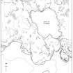
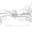
Map showing features connected with the canal and its surroundings at Rubh’ an Dùnain. (Colin Martin)
Dr Colin and Dr Paula Martin
2008
© Courtesy of HES (Dr Colin and Dr Paula Martin Collection)

DP 175308
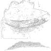
Plan and N elevation of the headland fort at Rubh’ an Dùnain. (Colin Martin)
Dr Colin and Dr Paula Martin
2008
© Courtesy of HES (Dr Colin and Dr Paula Martin Collection)

DP 175309
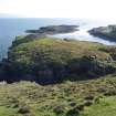
Headland fort from the W. Note the likelihood that much of its seaward interior has been lost to rock fall. (Colin Martin)
Dr Colin and Dr Paula Martin
2008
© Courtesy of HES (Dr Colin and Dr Paula Martin Collection)

DP 175310
Headland fort from the W. Note the likelihood that much of its seaward interior has been lost to rock fall. (Colin Martin)
Dr Colin and Dr Paula Martin
2008
© Courtesy of HES (Dr Colin and Dr Paula Martin Collection)

DP 175311
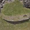
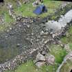
Vertical aerial photograph from drone of the headland fort at Rubh’ an Dùnain. (Edward Martin)
Dr Colin and Dr Paula Martin
2008
© Courtesy of HES (Dr Colin and Dr Paula Martin Collection)

DP 175312
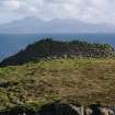
Headland fort from the NE, looking towards Rum. (Colin Martin)
Dr Colin and Dr Paula Martin
2008
© Courtesy of HES (Dr Colin and Dr Paula Martin Collection)

DP 175313
Headland fort, N face of wall, looking S towards Rum. (Colin Martin)
Dr Colin and Dr Paula Martin
2008
© Courtesy of HES (Dr Colin and Dr Paula Martin Collection)

DP 175314
Headland fort from the NE, looking towards Rum. (Colin Martin)
Dr Colin and Dr Paula Martin
2008
© Courtesy of HES (Dr Colin and Dr Paula Martin Collection)

DP 175315
Headland fort from the NE, looking towards Rum. (Colin Martin)
Dr Colin and Dr Paula Martin
2008
© Courtesy of HES (Dr Colin and Dr Paula Martin Collection)

DP 175316
Headland fort from the NE. (Colin Martin)
Dr Colin and Dr Paula Martin
2008
© Courtesy of HES (Dr Colin and Dr Paula Martin Collection)

DP 175317
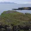
Headland fort from the NE, looking towards the islet of Sgeir Mhòr and the sheltered anchorage between. (Colin Martin)
Dr Colin and Dr Paula Martin
2008
© Courtesy of HES (Dr Colin and Dr Paula Martin Collection)

DP 175318
Headland fort, wall from interior looking N over Loch na h-Airde. (Edward Martin)
Dr Colin and Dr Paula Martin
2008
© Courtesy of HES (Dr Colin and Dr Paula Martin Collection)

DP 175319
Headland fort, aerial view from drone looking S. (Edward Martin)
Dr Colin and Dr Paula Martin
2008
© Courtesy of HES (Dr Colin and Dr Paula Martin Collection)

DP 175320
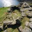
Headland fort, entrance. Scale 2 metres. (Colin Martin)
Dr Colin and Dr Paula Martin
2008
© Courtesy of HES (Dr Colin and Dr Paula Martin Collection)

DP 175321
Headland fort, intramural chamber adjacent to entrance. Scale 2 metres. (Colin Martin)
Dr Colin and Dr Paula Martin
2008
© Courtesy of HES (Dr Colin and Dr Paula Martin Collection)

DP 175322
Headland fort, interior of wall showing scarcement. Scale 2 metres. (Colin Martin)
Dr Colin and Dr Paula Martin
2008
© Courtesy of HES (Dr Colin and Dr Paula Martin Collection)

DP 175323
Headland fort, detail of chamber and external wall (on right) showing evidence of re-build. Scale 2 metres. (Colin Martin)
Dr Colin and Dr Paula Martin
2008
© Courtesy of HES (Dr Colin and Dr Paula Martin Collection)

DP 175324
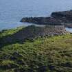
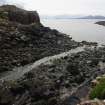
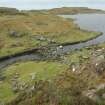
Headland fort (skylined, on left), the two nausts below it, and the canal leading into Loch na h-Airde. The islet of Sgeir Mhòr and the sheltered anchorage lie beyond. (Colin Martin)
Dr Colin and Dr Paula Martin
2008
© Courtesy of HES (Dr Colin and Dr Paula Martin Collection)

DP 175325
Headland fort (skylined, on left), the two nausts below it, and the canal leading into Loch na h-Airde. The islet of Sgeir Mhòr and the sheltered anchorage lie beyond. Rum is on the horizon, and the headland on the far left is Dùnan Thalasgair on Eigg, which according to tradition was a watch-post and signal-stance linked to Rubh’ an Dùnain. (Colin Martin)
Dr Colin and Dr Paula Martin
2008
© Courtesy of HES (Dr Colin and Dr Paula Martin Collection)

DP 175326
Vertical photograph by aerial drone of the two nausts with their upper hauling bays. (Edward Martin)
Dr Colin and Dr Paula Martin
2008
© Courtesy of HES (Dr Colin and Dr Paula Martin Collection)

DP 175327
The nausts at mid-tide, with the water just beginning to enter the lower basins. (Colin Martin)
Dr Colin and Dr Paula Martin
2008
© Courtesy of HES (Dr Colin and Dr Paula Martin Collection)

DP 175328
Rectified vertical photomosaic of the canal, quay, and nausts taken by aerial drone. (Edward Martin)
Dr Colin and Dr Paula Martin
2008
© Courtesy of HES (Dr Colin and Dr Paula Martin Collection)

DP 175329
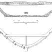
Interpretative survey drawing derived from the rectified vertical photomosaic of the canal, quay, and nausts. (Colin Martin)
Dr Colin and Dr Paula Martin
2008
© Courtesy of HES (Dr Colin and Dr Paula Martin Collection)

DP 175330
Oblique panorama of the upper canal and nausts. (Edward Martin)
Dr Colin and Dr Paula Martin
2008
© Courtesy of HES (Dr Colin and Dr Paula Martin Collection)

DP 175331
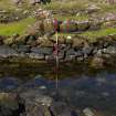
The upper canal from the edge of the northernmost naust. The 2-m pole marks a distinctive change in the stonework of the revetment on the far side of the canal. (Colin Martin)
Dr Colin and Dr Paula Martin
2008
© Courtesy of HES (Dr Colin and Dr Paula Martin Collection)

DP 175332
Detail of the change in the stonework between the lower and upper sectors of the canal. Scale 2 metres. (Colin Martin)
Dr Colin and Dr Paula Martin
2008
© Courtesy of HES (Dr Colin and Dr Paula Martin Collection)

DP 175333
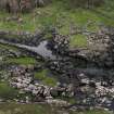
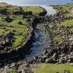
The lower end of the canal’s outlet to the sea, photographed at low water. This sector is not strictly a canal, but a cleared strip which runs towards the nausts to facilitate landing. Even so, some revetment to the edges is evident. The headland fort is visible at the upper left. (Colin Martin)
Dr Colin and Dr Paula Martin
2008
© Courtesy of HES (Dr Colin and Dr Paula Martin Collection)

DP 175334
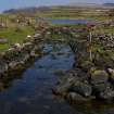
The upper canal leading into Loch na h-Airde. The naust entrances are partly obscured (centre right), while the blockage of the canal towards its entrance into the loch is clear. (Colin Martin)
Dr Colin and Dr Paula Martin
2008
© Courtesy of HES (Dr Colin and Dr Paula Martin Collection)

DP 175335
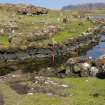
The upper canal leading into Loch na h-Airde, with the blockage part-way along it. The left-hand revetment is relatively intact, but that on the right appears to have been dismantled to its foundations and the stones thrown onto the bank. Tradition asserts that this was done to bring larger vessels into the loch. (Colin Martin)
Dr Colin and Dr Paula Martin
2008
© Courtesy of HES (Dr Colin and Dr Paula Martin Collection)

DP 175336
The upper canal leading into Loch na h-Airde, with the blockage part-way along it. The left-hand revetment is relatively intact, but that on the right appears to have been dismantled to its foundations and the stones thrown onto the bank. Tradition asserts that this was done to bring larger vessels into the loch. Scale 2 metres. (Colin Martin)
Dr Colin and Dr Paula Martin
2008
© Courtesy of HES (Dr Colin and Dr Paula Martin Collection)

DP 175337
The upper canal leading into Loch na h-Airde, with the blockage part-way along it. (Colin Martin)
Dr Colin and Dr Paula Martin
2008
© Courtesy of HES (Dr Colin and Dr Paula Martin Collection)

DP 175338
Oblique photomosaic taken from an elevated pole of the canal blockage. Scales 2 metres. (Edward Martin)
Dr Colin and Dr Paula Martin
2008
© Courtesy of HES (Dr Colin and Dr Paula Martin Collection)

DP 175339
Rectified vertical mosaic taken by aerial drone of the stone-built quay features on either side of the canal entrance into Loch na h-Airde. (Edward Martin)
Dr Colin and Dr Paula Martin
2008
© Courtesy of HES (Dr Colin and Dr Paula Martin Collection)

DP 175340
Tumbled stonework from the quay on the E side of the canal entrance into Loch na h-Airde. (Colin Martin)
Dr Colin and Dr Paula Martin
2008
© Courtesy of HES (Dr Colin and Dr Paula Martin Collection)

DP 175341
The edge of the quay on the E side of the canal entrance into Loch na h-Airde. (Colin Martin)
Dr Colin and Dr Paula Martin
2008
© Courtesy of HES (Dr Colin and Dr Paula Martin Collection)

DP 175342
The edge of the quay on the E side of the canal entrance into Loch na h-Airde. (Colin Martin)
Dr Colin and Dr Paula Martin
2008
© Courtesy of HES (Dr Colin and Dr Paula Martin Collection)

DP 175343
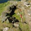
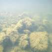
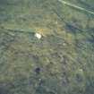
The basin beyond the entrance of the canal into Loch na h-Airde is deeper than its surroundings, relatively weed free, and filled with soft mud. Organic material tends to accumulate here. The items visible in this photograph are probably modern in origin but given its location adjcent to the quay earlier material may well be buried in the aenerobic substratum. (Colin Martin)
Dr Colin and Dr Paula Martin
2008
© Courtesy of HES (Dr Colin and Dr Paula Martin Collection)

DP 175344
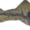
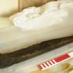
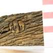
Boat component discovered at the N end of the loch by Dr David MacFadyen in 2000. It is a bite, part of a small four-oared boat of Norse type, and has been C14-dated to around 1100 AD. Scale 50 centimetres. (Colin Martin)
Dr Colin and Dr Paula Martin
2008
© Courtesy of HES (Dr Colin and Dr Paula Martin Collection)

DP 175345
Boat component discovered at the N end of the loch by Dr David Macfadyen in 2000. It is a bite, part of a small four-oared boat of Norse type, and has been C14-dated to around 1100 AD. Scale 50 centimetres. (Colin Martin)
Dr Colin and Dr Paula Martin
2008
© Courtesy of HES (Dr Colin and Dr Paula Martin Collection)

DP 175346
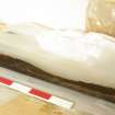
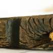
Treenail, or wooden fastening peg, from a boat component discovered at the N end of the loch by Dr David MacFadyen in 2000 which has been C14-dated to around 1100 AD. The treenail has been tightened with a wedge. Scale in centimetres. (Colin Martin)
Dr Colin and Dr Paula Martin
2008
© Courtesy of HES (Dr Colin and Dr Paula Martin Collection)

DP 175347
Part of a boat component discovered at the N end of the loch by Dr David Macfadyen in 2000. The piece is a bite, part of a small four-oared boat of Norse type, and has been C14-dated to around 1100 AD. This detail shows a wooden peg or treenail, and a slot cut in its side. Scale in centimetres. (Colin Martin)
Dr Colin and Dr Paula Martin
2008
© Courtesy of HES (Dr Colin and Dr Paula Martin Collection)

DP 175348
Top and side views of the bite found at the N end of the loch by Dr David Macfadyen in 2000. Below is a reconstruction of how it might have fitted into the midships section of a four-oared boat of the Norse faering type. (Colin Martin)
Dr Colin and Dr Paula Martin
2008
© Courtesy of HES (Dr Colin and Dr Paula Martin Collection)

DP 175349
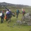
Access to Rubh’ an Dùnain is not easy. By land the loch is a 5-mile trek each way, often in poor weather and carrying equipment. This severely restricted work on the site in 2009. (Colin Martin)
Dr Colin and Dr Paula Martin
2008
© Courtesy of HES (Dr Colin and Dr Paula Martin Collection)

DP 175350
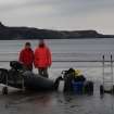
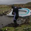
Access by boat from Glenbrittle is convenient but entirely weather dependant. This demanded a much more flexible approach predicated on exploiting windows of opportunity with a small family-based team. Here Dr Paula Martin and Peter Martin prepare to set out for the site with a load of equipment. (Colin Martin)
Dr Colin and Dr Paula Martin
2008
© Courtesy of HES (Dr Colin and Dr Paula Martin Collection)

DP 175351
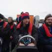
Fast, comfortable access is available – at a price – by rigid inflatable boat from Elgol. This occasion, in 2012, was underwritten by the BBC, who were making a programme. At centre is Dr Jon Henderson (University of Nottingham) who was presenting the programme and providing expertise on the archaeology of the site. On the right is Edward Martin, who has been developing drone photography and photographic rectification for the project. (Colin Martin)
Dr Colin and Dr Paula Martin
2008
© Courtesy of HES (Dr Colin and Dr Paula Martin Collection)

DP 175352
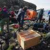
Filming, archaeological, and aerial drone equipment come ashore at Rubh’ an Dùnain. The drone system is in the box, centre foreground. (Colin Martin)
Dr Colin and Dr Paula Martin
2008
© Courtesy of HES (Dr Colin and Dr Paula Martin Collection)

DP 175353
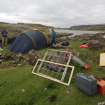
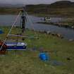
Setting up base camp on site in 2009. (Colin Martin)
Dr Colin and Dr Paula Martin
2008
© Courtesy of HES (Dr Colin and Dr Paula Martin Collection)

DP 175354
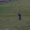
Setting out one of the primary baselines. (Colin Martin)
Dr Colin and Dr Paula Martin
2008
© Courtesy of HES (Dr Colin and Dr Paula Martin Collection)

DP 175355
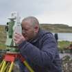
Dr Chris Burgess established a survey network with Total Station. (Edward Martin)
Dr Colin and Dr Paula Martin
2008
© Courtesy of HES (Dr Colin and Dr Paula Martin Collection)

DP 175356
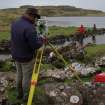
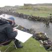
Within the Total Station network much of the detailed survey was done by plane table. (Colin Martin)
Dr Colin and Dr Paula Martin
2008
© Courtesy of HES (Dr Colin and Dr Paula Martin Collection)

DP 175357
Dr Chris Burgess established a survey network with Total Station. Within this framework the detailed survey was carried out with traditional methods. (Colin Martin)
Dr Colin and Dr Paula Martin
2008
© Courtesy of HES (Dr Colin and Dr Paula Martin Collection)

DP 175358
Beginning a survey of the canal. From left, Roger Miket, who first recognised the site’s potential in the 1980s, Dr David Caldwell of the National Museums of Scotland, and Peter Martin (Colin Martin)
Dr Colin and Dr Paula Martin
2008
© Courtesy of HES (Dr Colin and Dr Paula Martin Collection)

DP 175359
Roger Miket plots measurements as Peter Martin calls them out.
Dr Colin and Dr Paula Martin
2008
© Courtesy of HES (Dr Colin and Dr Paula Martin Collection)

DP 175360
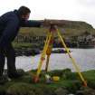
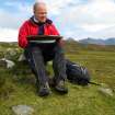
The site was potentially dangerous, and risk assessments were rigorous. Project Director Dr Colin Martin is more secure than he looks as he records details of the headland fort. (Paula Martin)
Dr Colin and Dr Paula Martin
2008
© Courtesy of HES (Dr Colin and Dr Paula Martin Collection)

DP 175361
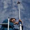
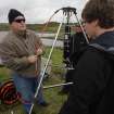
Edward Martin setting up the elevated pole-mounted camera system in 2009. (Colin Martin)
Dr Colin and Dr Paula Martin
2008
© Courtesy of HES (Dr Colin and Dr Paula Martin Collection)

DP 175362
Edward Martin prepares to take oblique photographs of the headland fort with the elevated pole-mounted camera system in 2009. (Colin Martin)
Dr Colin and Dr Paula Martin
2008
© Courtesy of HES (Dr Colin and Dr Paula Martin Collection)

DP 175363
Edward Martin composing the picture and adjusting the camera on the elevated pole-mounted camera system from his computer on the ground. (Colin Martin)
Dr Colin and Dr Paula Martin
2008
© Courtesy of HES (Dr Colin and Dr Paula Martin Collection)

DP 175364
Edward Martin, filmed by a BBC crew, steadies his aerial drone by the mouth of the canal prior to a photographic sortie. (Colin Martin)
Dr Colin and Dr Paula Martin
2008
© Courtesy of HES (Dr Colin and Dr Paula Martin Collection)

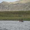
DP 175365
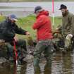
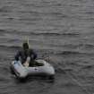
Attempts have been made to search the shallow loch bed, since it is likely that further early boat components will be found there. The simplest method has been to use a small inflatable raft pulled along rope lanes stretched across the loch by a snorkeller. (Colin Martin)
Dr Colin and Dr Paula Martin
2008
© Courtesy of HES (Dr Colin and Dr Paula Martin Collection)

DP 175366
Attempts have been made to search the shallow loch bed, since it is likely that further early boat components will be found there. The simplest method has been to use a small inflatable raft pulled along rope lanes stretched across the loch by a snorkeller. (Colin Martin)
Dr Colin and Dr Paula Martin
2008
© Courtesy of HES (Dr Colin and Dr Paula Martin Collection)

DP 175367
Attempts have been made to search the shallow loch bed, since it is likely that further early boat components will be found there. The simplest method has been to use a small inflatable raft pulled along rope lanes stretched across the loch by a snorkeller. (Colin Martin)
Dr Colin and Dr Paula Martin
2008
© Courtesy of HES (Dr Colin and Dr Paula Martin Collection)

DP 175368
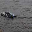
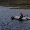
Trials have been made using sector scanning to search the loch bed for archaeological features. Here Dr Brian Abbott prepares the equipment for a test run. (Colin Martin)
Dr Colin and Dr Paula Martin
2008
© Courtesy of HES (Dr Colin and Dr Paula Martin Collection)

DP 175369
Trials have been made using sector scanning to search the loch bed for archaeological features. The equipment is seen here assembled and ready for launching. (Colin Martin)
Dr Colin and Dr Paula Martin
2008
© Courtesy of HES (Dr Colin and Dr Paula Martin Collection)

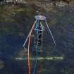
DP 175370
Trials have been made using sector scanning to search the loch bed for archaeological features. The equipment is seen here being positioned. Results so far have been encouraging, but a more sustained programme is required. (Colin Martin)
Dr Colin and Dr Paula Martin
2008
© Courtesy of HES (Dr Colin and Dr Paula Martin Collection)

DP 175371
Trials have been made using sector scanning to search the loch bed for archaeological features. Here the equipment has been positioned near the canal mouth. Results so far have been encouraging, but a more sustained programme is required. (Colin Martin)
Dr Colin and Dr Paula Martin
2008
© Courtesy of HES (Dr Colin and Dr Paula Martin Collection)

DP 175372
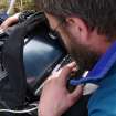
More work on studying the historic environment of Rubh’ an Dùnain is required. Here Dr Richard Tipping of the University of Stirling obtains some test cores from the loch bed. (Edward Martin)
Dr Colin and Dr Paula Martin
2008
© Courtesy of HES (Dr Colin and Dr Paula Martin Collection)

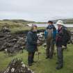
DP 175373
Dr Colin Martin (left), the Project Director, confers on site with Dr David Macfadyen (right), who found the 12th century boat timber in 2000.With them is Gavin Parsons of Sabhal Mor Ostaig, the Gaelic College on Skye, who is advising on place-name studies and other local cultural issues. (Edward Martin)
Dr Colin and Dr Paula Martin
2008
© Courtesy of HES (Dr Colin and Dr Paula Martin Collection)

DP 175374
Dr Colin Martin (left), the Project Director, confers on site with Dr David Macfadyen (right), who found the 12th century boat timber in 2000.With them is Gavin Parsons of Sabhal Mor Ostaig, the Gaelic College on Skye, who is advising on place-name studies and other local cultural issues. (Edward Martin)
Dr Colin and Dr Paula Martin
2008
© Courtesy of HES (Dr Colin and Dr Paula Martin Collection)

DP 175375
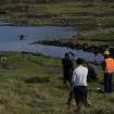
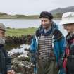
This site has elicited much interest and discussion from heritage agencies and others. Here, seated on the remains of a Neolithic chambered cairn overlooking Loch na h-Airde in September 2013, an informal international seminar is taking place. From left, Philip Robertson (Historic Scotland), George Geddes (Royal Commission on the Ancient and Historic Monuments of Scotland), Edward Martin (archaeological photographer), and Dr Ian MacLeod (Western Australian Museum). Behind the camera is Dr Colin Martin (University of St Andrews). (Colin Martin)
Dr Colin and Dr Paula Martin
2008
© Courtesy of HES (Dr Colin and Dr Paula Martin Collection)

DP 175376
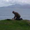
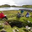
Philip Robertson of Historic Scotland takes a break from assessing Rubh’ an Dùnain’s archaeological and historical significance to Scotland and the wider world. (Paula Martin)
Dr Colin and Dr Paula Martin
2008
© Courtesy of HES (Dr Colin and Dr Paula Martin Collection)
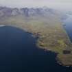
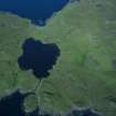
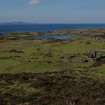

Aerial photograph of the Rubh’ an Dùnain peninsula from the W, with the Cuillin Hills rising in the background. Loch na h-Airde is close to the tip of the peninsula. Loch Brittle is on the left, with Glenbrittle at its head. (Edward Martin)
Aerial photograph of the W tip of the Rubh an Dùnain peninsula showing Loch na h-Airde and the canal linking it to the sea. The islet of Sgeir Mhòr provides a sheltered anchorage beyond the canal's mouth. (Colin Martin)
Aerial photograph of the headland fort and canal from the SE. Underwater indications of a stone-built quay can be seen on either side of the canal’s entry to the loch. Beyond the canal entrance a basin of deeper water largely clear of weed is visible. (Colin Martin)
