Field Visit


Date 20 March 2009
Event ID 606994
Category Recording
Type Field Visit
Permalink http://canmore.org.uk/event/606994
The remains of the fort on Dunagoil, which was first mapped in detail by Peter or Alexander May in 1780, are generally as described by the OS in 1976, and the significance of the site and the artefacts found in it to Iron Age studies has recently been reviewed by Harding (2004).
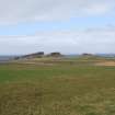
At a height of 35m above sea level, the fort sits at the NW end of a craggy basalt ridge with vertical cliffs on the NE and NW, a steep, uneven, drop to the sea on the SW and a gentle, but very irregular, descent to a natural cove some 200m to the SE. The fort measures about 85m from NW to SE by up to 20m transversely within the cliff-edge on the NW and NE and a ruinous timber-laced wall elsewhere that measures up to about 3.5m in thickness. The SW side is characterised by the presence of a large mass of in situ vitrified wall-core along much of its length and it is broken by an entrance about midway. There is what appears to be another entrance (revealed in an excavation trench) in the SE end, where the fort wall runs on to the edge of the precipice on the NE before turning and extending along the cliff-top for a distance of about 10m. There is no evidence that there was any form of wall along the remaining length of the NE side and the NW end, but at a distance of about 35m from the SE end a crevice that would have afforded relatively easy access to the summit has been blocked by a drystone revetment, the outer face of which stands to a height of at least 0.7m. Another blocked crevice, this time outside the fort some 75m to the SE, may have been designed to hinder progress towards the fort from that direction. It lies on the line of easiest access to the summit from the lower terrace and the cove, and even today the blocking stands up to about 1m in height. Apart from excavation trenches, the interior of the fort is featureless.
Harding (2004) has recently argued that the terrace immediately NE of the fort formed some kind of contemporary ‘bailey’. Whilst this area is defined by natural features linked by comparatively short lengths of thick stone wall, the vitrified stone that was observed in these walls on the date of visit seems to be in re-use, representing material that has either been robbed from the earlier timber-laced wall or tumble that has fallen down the slope from the ruinous fort. In addition to the probable prehistoric burial cairns (NS05SE 13) within this area, there are extensive remains of later cultivation (NS05SE 29) that include rig-and-furrow and clearance cairns.
Other features in the vicinity of the fort include a possible stance for a timber round-house (NS 08509 53052), dug into the SW-facing slope 50m S of the E end of the fort. It measures about 5m in diameter and it may be associated with a series of stony banks close-by that form small enclosures.
Visited by RCAHMS (GFG, AGCH, ARG) 20 March 2009.