Field Visit


Date 28 September 1989
Event ID 546779
Category Recording
Type Field Visit
Permalink http://canmore.org.uk/event/546779
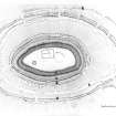
The White Caterthun is one of the most spectacular forts in Scotland, commanding a wide sweep of country from a low hill on the NW side of Strathmore opposite Brechin.
Detailed survey of the earthworks has shown that the defences of the fort reflect several periods of construction, the earliest of which is a heavily robbed rampart (A) enclosing an area measuring about 335m from NE to SW by 210m transversely. Around the N quarter, where it is overlain by a later defence comprising double ramparts with a medial ditch, this early rampart is visible as a substantial terrace flanked by shallow quarry scoops along its uphill side. Elsewhere, however, it has been so heavily robbed that its course can only be detected from the flanking quarry scoops.
A notable feature of this fort is the provision of numerous entrances; around the N quarter six original gaps can be identified, and others must have existed elsewhere. Roughly concentric to this early fort, set some 28m to 40m down the slope, there are traces of another line of earthworks (B). They are most easily identified around the W half of the circuit, where they comprise short segments of ditch with the spoil cast down the slope, but traces of a low scarp is visible extending their line immediately below the later ramparts (F) on the SE side.
The date and purpose of these curious earthworks are unknown but it is possible that they are part of an unfinished line of defences supporting the early rampart (A). The extensive robbing of this rampart, which appears to have taken place at some earlier date than the construction of the overlying line of defence, can probably be accounted for by the construction of the massive stone fortifications at the core of the fort. These defences (C-E) are unrivalled for their sheer scale and must have entailed the collection of stones for some distance around. The mound of rubble from its inner wall (C) is about 20m wide and from 1.5m to 4m high, and the spread of stones beyond it (D) is probably the remains of a substantial outer rampart. Fronting this rampart is an impressive ditch with a counterscarp bank (E). A curious feature of these defences is that there is no obvious sign of an entrance. Causeways across the ditch on the SE and W are composed of tumbled stones, while the gap in the ditch on the SW may be the result of a relatively modern track shown on the first edition of the OS 6-inch map (Forfarshire, (1865), Sheet xix).
On the E, however, immediately S of the modern path up to the fort, there are possible traces of an original gap in the earthwork, but there is certainly no evidence of a gap in the inner wall. The double ramparts with medial ditch (F) which overlie the early rampart (A), follow a roughly concentric course around the central stone fort and were almost certainly added as an outwork to it. Like the early rampart this line of defences has numerous entrances; there are thirteen gaps, of which at least ten are original, around the N quarter matching those of the earlier rampart. The annexe on the NE (G) was subsequently added to these outworks.
Despite the scale of the effort that has been put into the construction of the defences, there is very little evidence of occupation within the earthworks. In part this may result from the episode of ridged cultivation that is detectable within the interior of the central stone fort. The most obvious features within the massive stone wall are a well at the SW end and a turf-banked enclosure on the NW. Beneath the turf-banked enclosure, however, there are traces of an enclosure some 37m in diameter, defined by a shallow groove in the surface of the turf. Immediately to the NE there is possibly a second enclosure, which measures about 23m in diameter within two grooves set 3m apart.
The closest parallels to these enclosures are the surface remains of palisade trenches in the Border counties. Apart from these enclosures, the only other evidence of structures that stood within the earthworks are provided by eight shallow scoops that are strung out in a line between the stone fort and the earlier rampart on the SE, and a small platform in a similar position on the W. One of the scoops on the SE is probably a ring-ditch house, whose rear appears to be overlain by the counterscarp bank of the ditch that accompanies the stone fort. Three of the other scoops, however, appear to have been cut back into the counterscarp bank. It is likely that all these scoops mark the positions of timber houses but it is not known if any of them relate to the occupation of the fort.
Several other ring-ditch houses are scattered across the E flank of the hill outside the defences (NO56NW 43; NO56NE 32). In the absence of excavation, the dating of this site must remain uncertain.
Visited by RCAHMS (SH) 28 September 1989