Field Visit


Date 11 August 1908
Event ID 1088509
Category Recording
Type Field Visit
Permalink http://canmore.org.uk/event/1088509
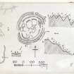
The fort of Longcroft (RCAHMS 1915, fig. 100) occupies a prominent position on the southern extremity of a ridge which forms the watershed of the Whalplaw and Soonhope Burns, overlooking the farm of Longcroft some 500 yards distant to the south-west, some 400 feet above it and 1150 feet above sea-level. The ground falls sharply away on all sides except to the northward, where the hill continues to rise by an easy gradient. The fort is oval in form and appears to have measured interiorly some 275 feet by 225 feet. The lines of the defences are somewhat difficult to determine owing probably to a lengthy occupation of the site and modification of the original features, but there appear to have been three concentric stony ramparts. The inner rampart as it passes towards the west gives place to an oblong enclosure some 110 feet in length by 40 feet in breadth over all: beyond this it reappears but shows little more than a stony scarp as it passes eastward. The middle rampart as it curves round on the south arc broadens out and shows a berm some 3 feet 9 inches wide on its outer slope. Where best preserved, towards the north-east, the defences measure overall some 88 feet, the ramparts showing elevation on the inner faces respectively of 3 feet, 4 ½ feet; and 5 feet, and on the outer of 4 feet, 6 feet, and 9 ½ feet. There are two entrances, one towards the west-south-west, and the other from the east. The former, which is evidently original, occurs immediately to the south of the oblong enclosure on the west side. In the interior there are the remains of six large enclosures, and signs of other small circular foundations. What appears to be a well exists between the innermost and the second rampart on the east side to the north of the second entrance. Well-defined tracks lead up the hill towards the fort from the south.
RCAHMS 1915, visited (AOC) 11 August 1908.
See Antiquaries, xxix. p.129 (plan and secs.); Christison, p.229, Ber. Nat. Club, 1882-84, p.312; ibid., 1894-95, p.33.
OS Map: Ber., xiii. NE.