Field Visit


Date 3 August 1908
Event ID 1088186
Category Recording
Type Field Visit
Permalink http://canmore.org.uk/event/1088186
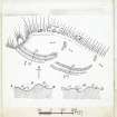
10. Hill Fort, Chester Hill, Greystonelees.
On the summit of Chester Hill, at an elevation of about 560 feet above sea-level and some ¾ mile south of Burnmouth railway station, are the remains of a fortified enclosure (fig. 2 [DP 229121]). It is crescentic in form, resting on the edge of a steep slope to the northward and contained within a broad rampart and ditch. The greatest length is some 408 feet, and the breadth 228 feet. The rampart, which appears to be of earth, is still in places about 6 feet high above the bottom of the ditch, and the distance from its crest to the top of the counters carp measures70 feet. The entrance has been at the south-east. The site has been frequently ploughed over, and the defences, except towards the southwest, are much destroyed. A large annex measuring some 297 feet in length by 243 feet in breadth has been formed against the eastern end of the fort, and has been defended by a double rampart slighter than that of the main enclosure, with an intervening trench.
RCAHMS 1915, visited 3 August 1908.
OS Map: Ber., xii. NW