Field Visit


Date 17 November 2017
Event ID 1042589
Category Recording
Type Field Visit
Permalink http://canmore.org.uk/event/1042589
This heavy anti-aircraft battery is situated in Khyber Field, Mugdock Country Park, about 630m W of Mugdock Castle (NS57NW 9). It comprises four gun emplacements, a command post, a radar block, and at least 40 concrete building platforms associated with the camp to the S. In addition, there is a small telecommunications hut and a water cistern located N of the track leading past the castle to the junction with the Broadmeadow and Craigallian public roads. These are not visible on an RAF vertical aerial photograph (Scot-CPE-UK-0256-5196) flown on 11 August 1947. It was one of at least 43 such batteries that were constructed to protect the industries in the centre of Glasgow and along the banks of the River Clyde from aerial attack by the Luftwaffe during WWII. However, it was also later one of at least 78 heavy anti-aircraft gun emplacements that were deployed to counter the threat from the Soviet Union during the Cold War c.1950-56 (WO106/5912).
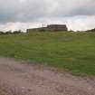
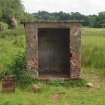
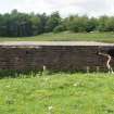
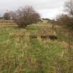
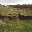
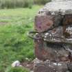
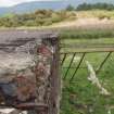
The four gun-pits (NS 54422 77292, NS 54381 77269, NS 54371 77242, NS 54344 77232), which are approached from the track by a short grass-grown branch leading S, are planned around the circumference of a circle with a radius of 34m, pivoted on a NNE to SSW axis. They can be separated into two pairs, one on the NE arc of the circle and one on the SE but all are of the same design and are protected by earthen bunds. However, the most northerly has also been terraced into the natural S-facing slope. Each is a regular dodecahedron on plan, measuring 13.5m in diameter within brick blast walls 0.5m thick and 1.85m high. Single gateways accounting for the three missing sides, measure 3.6m wide and face towards the command post. In each gun-pit, five ammunition lockers measuring 1.8m broad by 1.88m deep within brick walls 0.5m thick and 1.63m high, are built against the inner side of the blast wall. They are symmetrically arranged with one positioned opposite the entrance - although the latter has been demolished in the SE gun-pit. All have flat concrete roofs, raised concrete floors and one open side parallel with the wall. Two more diametrically opposed ammunition lockers, measuring 1.9m broad by 1.4m deep within brick walls 0.5m thick and 1.62m high, open on to the centre of the gun-pit. However, these have been removed from the SE pair leaving only their raised concrete floors. Behind these is a crew shelter, situated outside the line of the blast wall, to which access is had from the gun-pit by a short flight of four steps - the lowest of which on is truncated on one side to provide space for a small square drain. The shelters, which are rectangular on plan, measure 4.7m long by 2.25m broad within brick walls 0.5m thick and 2.15m high. A circular perforation in the roof was provided for the chimney pipe of a stove. These once stood upon a small rectangular concrete plinth with raised sides, which still largely survive close to their original location. An air brick just below the roofline at one end vented the shelters’ interiors. The hard standings, which in at least one instance is slightly raised at the centre to facilitate drainage, incorporate cast concrete roundels measuring 4.3m in diameter; while the holdfasts set within them comprise a circular arrangement of ten metal fittings measuring 2.6m in diameter and a cable duct running towards their centre.
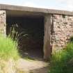
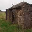
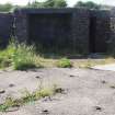
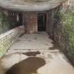
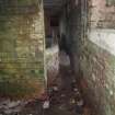
The command post (NS 54349 77267), which is also largely brick-built and buried in an earthen bund, is situated WNW of the branch track about 20m from each gun-pit. It is rectangular on plan and measures 20.4m from NNE to SSW by 9.4m transversely over brick walls up to 0.6m thick and 2.35m high. A concrete terrace on the ESE supports the platform for the height finder on the SSW, but the terrace is 1.3m broader on the NNE, in order to provide additional space for the spotting telescope, the predictor, the cable terminus shelter and the telephone exchange equipment – this last being accessed externally via a flight of steps leading down to two small square compartments. Seven ducts emerging from the ESE wall of the cable terminus shelter transmitted the electrical circuitry to each of the gun-pits, initially via channel-cut concrete blocks that are visible on the ground surface immediately in front of the building. At the back of the terrace is a porch that originally sheltered a flight of steps that led down to the control rooms, but this has been subsequently blocked-off, turning the space into another shelter. The control rooms occupy a block attached to the WNW side of the terrace, as well as the wings to the NNE and SSW. Like the shelters, they are protected by a flat roof of reinforced cast concrete covered with a thick layer of bitumen. Following the removal of the stairs, access to the interior from the terrace was had via a flight of steps leading down from the hatches at the end of each wing. Each wing contains two linked compartments used as offices or stores. The doorways between them retain their timber frames, and aside from small vents in their NNE and SSW walls, each pair has a rectangular window in the WNW wall. In addition, the WNW compartment in the NNE wing contains an internal widow looking into the plotting room, which, together with the compartment reserved for the retransmission unit, occupies the block between the wings. The plotting room is lit by two windows looking out on to the terrace and distinguished by doorways connecting it with the adjacent wings and six rectangular wood-framed vents situated just below the roof level in the WNW wall. In addition, there is an entrance at the NNW corner, measuring 2m wide, which leads out to a sunken, brick-lined concrete track which curls to emerge at the NE corner of the building. However, this is a later feature that is not depicted on the RAF vertical aerial photograph (Scot-CPE-UK-0256-5196) flown on 11 August 1947. The compartment for the retransmission unit is also lit by a window looking out on to the terrace and contains four wood-framed vents just below roof level in the WNW wall. However, its NNE wall has been pierced on the ESE to allow a later sheep run, measuring 0.4m broad and 7m in length, to pass into the plotting room - its WNW side being formed by a neatly capped brick wall 0.22m thick and 0.87m high.
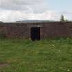
The radar block (NS 54276 77291), surrounded by the remains of a deflated earthen bund up to 0.4m high, is situated 70m WNW of the command post. It measures 6.2m square over brick walls 0.4m thick and 1.5m high and is capped by a flat roof of reinforced cast concrete, immediately below which extend the remains of a series of iron loops - originally one at each corner with three in between. There is a central entrance on the SSW surmounted by a flush concrete lintel, but there is also an aperture at the NE corner where the brickwork has been partly demolished. The interior is divided into three compartments, the one in the centre providing access to those on each side. Two circular ducts located 0.27m below the roofline in the WNW and ESE walls were probably provided for cabling connected with the array.
The small telecommunications hut (NS 54497 77472, NJ57NW 45) is situated about 210m NNE of the gun-pits and 7m SSW of the fence bordering the scrub woodland in Castle Strip. It measures 1.23m from NNE to SSW by 1.08m transversely, within cement skimmed brick walls 0.1m thick up to 1.47 high. The door is on the WNW and it has a flat, reinforced cast concrete roof that slopes down from WNW to ESE. There is a circular aperture for cabling in the concrete floor adjacent to the NNE wall. Although no fittings survive, an iron back plate lying outside the entrance probably originated from the interior.
The rectangular cistern (NS 54353 77355) is situated on a grassy crag overlooking the track leading WNW of the castle, about 50m NNW of the gun-pits. It measures 13.2m from WNW to ESE by 4.2m transversely over cement skimmed brick walls up to 1.2m high. A low plinth surrounds the base, while the sides and corners are further strengthened with buttresses. It has a flat concrete roof with a square manhole cover and a broad rectangular setting of vertical pipes each of which has been plugged with concrete. An enclosure measuring 3.1m from NNE to SSW by 2.15m transversely within concrete walls 0.24m thick and up to 0.7m high, occupies the ESE end of the cistern’s superstructure. It is accessed by a narrow doorway close at the SW corner from which a single step descends to a brick-trimmed, concrete floor. Squared wooden posts bolted into place at three of the corners hint at the possibility that these supported a metal tank.
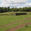
What remains of the associated camp (centred NS 54370 77143) occupies an area of about 0.9h. It is situated 40m S of the gun-pits, where the grass-grown foundations of at least 40 rectangular buildings are terraced into the south-facing slope immediately N of Mugdock Wood. The platforms are divided into two groups by the grass-grown, metalled track that leads SSW from the gun-pits. There are 13 platforms arranged in nine tiers on the W, some of which are built on brick foundations up to 0.8m high. The footprints of these buildings vary from 7.5m by 4.5m transversely to 17.9m by 4.5m transversely. At least one (NS 54305 77129) has a flight of steps on the S and was perhaps linked by a step and a corridor with a neighbour to the WSW (NS 54291 77125); while the six platforms built immediately adjacent to the track had doors in their ESE walls. To the E of the track there are 27 platforms arranged in six tiers. One (NS 54340 77148) immediately adjacent to the track retains enough of its cement skimmed, brick superstructure to outline a doorway 0.88m wide in the WNW wall. This also contains within it a rectangular concrete stance (NS 54341 77148) measuring 2m from WNW to ESE by 1.57m transversely. A longer platform further up slope to the NNE (NS 54351 77161) retains a flight of steps on the S, while a path to its NNE becomes a ramp as it curls round the WNW of the platform above (NS 54353 77169). This is attached to an upstanding brick and concrete structure, which bridges the gap between it and the longest platform in the camp situated immediately to its NNE (NS 54360 77174). This structure measures 6m from WNW to ENE by 3.3m transversely, within brick walls 0.35m thick and 2.2m high. However, part of its flat reinforced cast concrete roof now dangles from its WNW end, being suspended only by some of the iron rods. This indicates that the structure originally comprised three compartments, but it is unclear whether this one enclosed the generator pad which now seems to extend a little SSW of its building line. By contrast, the central compartment is distinguished by an entrance on the NNE measuring 3.3m wide, while there are two smaller entrances on the S. One is a conventional doorway, while the other is twice the width. This compartment also provides the only means of access to the ESE compartment, which was lit by a large window in the wall opposite the door. Its NNE wall rests upon the dwarf wall of the adjacent building which stands to a height of 0.55m – thus demonstrating the former’s secondary character. The SSW wall of this compartment may also be secondary, but a curved iron rib springing from its SSW face is matched by a chase for another etched into the exterior of the ESE wall and this confirms that the building platform to the SSW must have been roofed like a Nissen hut. However, an edifice at its ESE end was separately roofed with concrete slabs. The building to the NNE may have been roofed in a similar way, but the evidence for this are the perpendicular iron bolts set out at regular intervals on the crest of a series of small square pillars that are incorporated in the dwarf walls. A short flight of steps on the NNE provided access to its interior. The remainder of the platforms in this sector were largely supplied for accommodation and some of these may have had external boiler houses; but the large platform (NS 54380 77130) situated 45m SE of the standing structure may have been a refectory with a kitchen attached on the N, while a series of latrines were located in a building immediately to its NNE (NS 54397 77139).
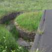
Apart from what may be a sump (NS 54227 77120) at the SW end of the camp, few traces of the drainage scheme can be observed.
Despite comments to the contrary, this battery was armed by March 1941 with four mobile guns associated with a tented camp, but this had given way to the more permanent structure by 1942. (WO166 2390).
Visited by HES, Survey and Recording (ATW, GFG, AKK), 17 November 2017.