Crawford Castle Survey


Date February 2017 - July 2017
Event ID 1042292
Category Recording
Type Field Visit
Permalink http://canmore.org.uk/event/1042292
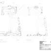
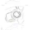
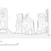
Crawford Castle was surveyed in 2017 as part of the Connected with the Clyde 2 project. The survey was carried out with a plane table and 3D scanner, particularly important for recording the precarious ruins which had partly collapsed the previous winter. A site plan and sections were drawn up at a scale of 1:500 and plans and sections of the upstanding ruins at 1:100.
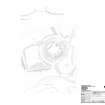
Crawford Castle sits on a terrace on the right bank of the Clyde on the opposite side from the modern village. It comprises a 12th-14th century motte and bailey, or landscape garden of 16th century date, on the W and a stone castle which shows traces of at least three phases of development between the 15th and 18th centuries.
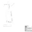
The motte makes use of the river terrace of a side valley of the Clyde cut by the Camps Water to gain extra height to the SE, although the river has since retreated to the E. The motte measures 54m at its base from NW to SE by 53m transversely and stands some 5m in height above the level ground to the N and 8m above the lower terrace to the SE. The ditch is visible on all sides except the SE and is up to 1.3m in depth and 9m in breadth and there are traces of a counterscarp bank on the W. There are two causeways across the ditch, one to the NE and the other on the WNW. That on the NE has the appearance of an intentional manmade feature with well-made butt ends to the ditch on either side; whereas that on the WNW appears to be the result of a lower terrace cutting the NW edge of the higher ridge to the W, obliging the constructors to terminate the ditches to either side as it would have required an awkward step between the two. A visible terrace cuts diagonally up the side of the mound from the NE causeway to the N corner of the enclosure, but this may be a modern ramp providing graded access at demolition. A roughly rectangular bailey or garden enclosure extends WSW from the motte, making use of a natural higher ridge on the river terrace, measuring 38m from N to S by 26m transversely. A bank is visible along the S edge where the external drop is greatest down to the river, but not along the other two sides. However, a substantial earthen bank some 4m across and about 0.5m in height stood at the base of the terrace that defined the W edge of the bailey or garden and there is another bank along the bottom of the terrace on the S. The banks sited below the bailey or garden suggest a plantation enclosure, of which the large trees on the site are a relic.
The top of the motte measures 29m from SE to NW by 23m transversely, but there is no surviving evidence of any features belonging to a pre-stone phase. It is now occupied by a stone-built castle or enclosure which has been significantly modified on at least two occasions, each phase of which will described in turn.
In the primary phase, which dates to the 15th century, the castle walls were built of coursed rubble, mainly whinstone with pinnings, 1.4m in thickness, that may be traced on the NW, NE and along part of SE, but has largely been rebuilt on a different line on the SW where the first few metres of the return of original wall face have survived rebuilding at the NW corner and the SW corner has been altogether lost. The enclosure measured 25.5m from NW to SE by 22.5m transversely. The SE curtain is not at right-angles to the other sides. However, it may have been designed to provide a postern gate below the SE range, which is at right-angles to the NE curtain and parallel to the NW side. The only definite feature in the walls of this phase is a return in the outer face of the wall on the NE for a garderobe chute towards the SE end, implying a building standing to at least first floor level at that corner which has now gone (see SE range below). The entrance is presumed to have been in the NE where the embanked trackway winds up the mound from the causeway across the ditch. However, it is more likely to be in the middle of this wall where no building ranges impinged upon it than towards the N corner where the track comes up. There is no sign of any significant defensive work associated with it.
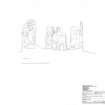
The rectangular building on the SE which is also part of the primary phase, is part of a longer SE range and has stonework similar to that of the primary curtain walls. Measuring 11.6m by 6.6m over walls 1m in thickness, it stood to two storeys with basement and attic floor. Its basement was lit by at least one square-headed chamfered slit window, dressed with yellow sandstone. This is similar to another on the SW end of the building at second floor level where there is a blocked, chamfered sandstone window opening with a square head like that at basement level. The character of these openings suggests a 15th century date for this phase. A raggle on the NE end above head-level suggests that there was another building on the NE, with an entrance at ground level between it and the neighbouring building, suggesting access to a postern gate. This building also contained the garderobe at first floor level on its NE that emptied on the outside of the NE curtain and a scar in the wall at head-height level suggests a stone vault. Half way along the exterior or SE wall of the building there is a broad pillar that extends 1m from the building with two sloping plinths at basement level, reducing its size as it ascends. It contained a circular stairwell for a turnpike from the first floor, and may therefore be secondary, belonging to the same phase as the vaulted basement. The splay of the slit window was reduced in this phase and blocked in a third phase. Two large windows at second and attic floor are dressed with red sandstone chamfered rybats. These were blocked in the third phase too, when a fireplace was inserted at first floor blocking in a large window opening, the blocking of which has since collapsed in its ruinous state. The walls at the W corner of the range above the basement were cut back by 1m at its W corner and finished with plaster suggesting it was not bonded into whatever structure filled the space between it and range to the SW.
It is possible that the basement vault that is incorporated into the return of the NE wall of the SW range that was added in the 17thcentury, most of which has been robbed, is part of a range along the NW curtain parallel to that on the SE in the primary stone phase. A scar for a vault may also be seen further to the NE on the inside of the curtain, which indicates it ran to within 3.5m of the NE curtain. Its parallel SE wall does not survive at all and has been completely demolished. A projecting turret with a vaulted base for a stair turret from the first to the second floor on the NW exterior was constructed either in this phase or a secondary phase which dates to the late 16th century. The stair turret was supported on two walls, 1.5m thick, with a stone vault 3m across, extending at right angles from the curtain wall for an unknown distance that has since been demolished and blocked in above ground floor level, with a recess at ground level 0.6m deep. The slope of the motte precludes it extending very far. A blocked door with yellow sandstone rybats is visible on the inside wall in the N corner of the phase two SW range that provided access to the stair and there is a similar blocked opening at the second floor. The rybats of the first-floor door are dressed with narrow quirked roll mouldings of later 16th century or early 17th century date. This suggests the stair and possibly the turret that goes with it is late 16th century in date. The different character of the dressings suggest that the stair turret is secondary in date to the primary stone phase. It is noted that a thick quirked roll moulding with a hollow and external quirked roll for a window opening of 16th century date recorded by RCAHMS on an earlier survey in the 1980s may be from this phase too, but was not located at the date of survey.
In phase three of the stone castle, which dates to the late 17th century, a new range was constructed that realigned the SW side of the castle at a more acute angle and was built to stand to two stories with attic rooms. This may have incorporated the building along the NW since the basement vault is still visible in the ruins of the NE wall of this new range. However, there is no trace of a vaulted basement in this new range and it included two external entrances at ground floor level, indicating a change in the orientation of the building, allowing external access other than via the NE entrance or a postern on the SE. It displays at least two phases of openings, several being blocked in a secondary stage. At first floor level the great height of the window openings suggest a great hall. Corbels are visible at first and second floor levels that supported a wooden floor. The primary openings marked by red sandstone rybats and yellow sandstone lintels decorated by bolection mouldings of late-17th or early-18th century date. A broad splayed opening at ground floor level at the SE end of the wall suggests a butt joint to a structure between it and the SE range that has been completely demolished, but must have connected the two buildings, and appears to pre-date this range.