Field Visit


Date 15 October 2017 - 17 October 2017
Event ID 1032992
Category Recording
Type Field Visit
Permalink http://canmore.org.uk/event/1032992
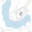
This castle comprises a late medieval tower, enclosure and later buildings situated on a promontory in the bend of the river Clyde.
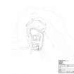
The shell of the small late medieval tower (A) stands on a low promontory on the SE side of the River Clyde, about 800m N of the road access at Woodend . The tower is much reduced by stone robbing, the entire external face having been removed along with much of the internal face and presumably the material that formed at least one upper floor.
The rump of the tower stands on a natural rise which is enclosed on three sides by what probably represents the much-reduced remains of a stout wall. At the SW this survives as a low stony bank about 3m in thickness and 0.2m in height which follows the break of slope to the SW and then to the N where it turns to the NE and becomes a broad terrace some 2m in height. Though apparently a continuation of the same feature the terrace has clearly been accentuated by ploughing, both on the terrace itself and within the field to the NW. At the N corner of the enclosure, the terrace is reduced to a low plough-damaged bank, obscured by a later building (described below) and field clearance. The bank runs to the SE where it terminates at the edge of the river terrace.
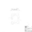
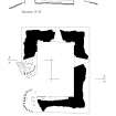
Enough of the interior survives to give an internal size of 8.6m from NE to SW by 5.6m transversely and a faint scarp outside the NW wall in particular suggests that the thickness of the walls was once about 2.4m, while they now stand to 2.3m in height at the W corner. The masonry is of small rubble bonded with a strong lime mortar, and the surviving sandstone facing stones are roughly squared and partly laid in courses, the largest measuring only 0.4m in their longest dimension. Both the NW and SE walls have a single window opening set towards the SW end, while the SW wall has a similar opening in the centre. In each case they are broadly splayed with sloping sills, and a photograph taken in 1955 shows the SE window in much better condition. The entrance is not visible: it may have stood in the NE end of the SW wall where little masonry survives, but equally it may have been provided at an upper level, in which case the gap may indicate the location of the stair from the first floor. The lowest story has been vaulted, and the first courses of the vaulting are still identifiable in the NW and SE walls. Within the enclosure, some 15m E of the tower, there are what appear to be the remains of a large rectangular building (B), perhaps coeval with the tower. Visible as a platform, it measures some 18.5m from NW to SE by 10m over a wall that has spread up to 2.5m in thickness and only 0.1m in internal height. This building may have an entrance in the SW wall with what is possibly a midden hollow immediately to the W.
A third building on the site (C) is presumably post-medieval in date and overlies the N end of B and the outer enclosure wall. It measures about 21.5m from ENE to WSW by 6.8m over a stony wall which, were best preserved, measures 1.3m in thickness and 0.5m in height. Possibly separated into three compartments, this building is now partially obscured by field clearance or demolition rubble at both ends.
There is no suggestion from the surface remains of either a motte or a later prehistoric fort at the site. The tower itself can be compared to the more simple examples of 16th century tower architecture found in Peebleshire to the E (e.g. Colquhar or Hutchinfield) but is less elaborate it its design than others of the same period (e.g. Chapelhill or Eddleston) (see RCAHMS 1967).
The roofless tower is depicted on the 1st edition of the OS 25 inch map (Lanark Sheet XLIII.2, 1864) and was described in some detail in the contemporary OS Name Book (No. 41, 44), the local minister informing the OS surveyors of a local tradition that the site was a favourite of James V. Some hundred years earlier, the site of ‘Bour’ was depicted on Roy’s Military Map (1747-55). The tower takes its name from Wandel parish, united with Lamington in 1608 (Orig. Par. Scot. 1, 171-3). Unfortunately the early histories of that parish make it unclear whether this site, or another at Hartside (where no known remains have been found), was the principal secular residence during the late medieval period, although it seems most likely that the building was originally constructed by a member of the Jardine family (New Stat. Acc. 6, 818; Irving and Murray 1864).
Visited by HES Survey and Recording (GFG, PJD, AM) 15-17 October 2017