Measured Survey


Date 9 October 2015
Event ID 1014730
Category Recording
Type Measured Survey
Permalink http://canmore.org.uk/event/1014730
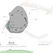
The plan taken by RCAHMS in 1998 (Welfare 2011, 80, 389) was revised to illustrate the character of the ring following its restoration for public display after the completion of Richard Bradley's excavations. The cairn is delimited by the surviving kerbstones and a robber trench that can be traced in the short grass throughout much of its circuit, while the recumbent setting (1-3) and all the orthostats (5, 8, 9) requiring reinstatement (except 12 and 13) have now been re-erected. However, the west flanker (1) has been positioned well back from the recumbent setting (2, 3), which appears to be an error; and it is most unusual for flankers (1, 3) and orthostats (9) to be set with their long axes at right angles to the circumference of the circle.
The infilling of the disused quarry to the west of the recumbent stone circle was still incomplete on the date of this visit.
Visited by HES (ATW and AMcC), 9 October 2015.