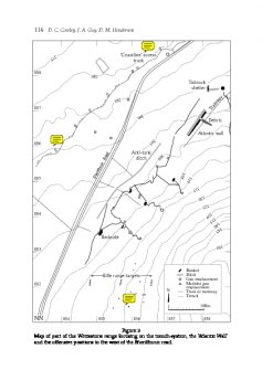
Map of part of the Whitestone range focusing on the trench-system, the ‘Atlantic Wall’ and the offensive positions to the west of the Sheriffmuir road.
WP 001431
Description Map of part of the Whitestone range focusing on the trench-system, the ‘Atlantic Wall’ and the offensive positions to the west of the Sheriffmuir road.
Date 1999
Collection Records of the Royal Commission on the Ancient and Historical Monuments of Scotland (RCAHMS), Edinbu
Catalogue Number WP 001431
Category Digital Files (Non-image)
Scope and Content Cowley, Guy and Henderson 1999 Fig. 1
Permalink http://canmore.org.uk/collection/1323531
File Format (PDF) Adobe Acrobat document
Attribution: © Crown Copyright: HES
Licence Type: Full
You may: copy, display, store and make derivative works [eg documents] solely for licensed personal use at home or solely for licensed educational institution use by staff and students on a secure intranet.
Under these conditions: Display Attribution, No Commercial Use or Sale, No Public Distribution [eg by hand, email, web]


