
Glenlochar


Temporary Camp (Roman)
Site Name Glenlochar
Classification Temporary Camp (Roman)
Alternative Name(s) Glenlochar 4; Montford
Canmore ID 64697
Site Number NX76SW 6
NGR NX 73843 64728
NGR Description Centred NX 73843 64728
Datum OSGB36 - NGR
Permalink http://canmore.org.uk/site/64697


- Council Dumfries And Galloway
- Parish Crossmichael
- Former Region Dumfries And Galloway
- Former District Stewartry
- Former County Kirkcudbrightshire
NX76SW 6 centred 73843 64728
(NX 7382 6463) Roman Marching Camp (R)
(Site of)
OS 6" map (1957).
Formerly entered at cited location centred NX 7382 6470.
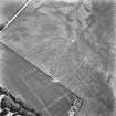
This camp is part of a complex of forts and camps at Glenlochar, ? Agricolan to Antonine
(Iinformation from J K St Joseph 1949).
J K St Joseph 1951; J K St Joseph 1958.
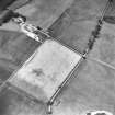
Centred NX 7382 6470. The cropmark on the St Joseph AP DV 071 suggests that this camp is twice as large as is published on the OS 6" (1957).
No trace on ground.
Surveyed from St Joseph AP and ground observation.
Visited by OS (RD), 30 July 1968.
Roman Camp
(site of) [NAT] (at NX 7383 6471)
OS (GIS) MasterMap, March 2011.
Scheduled (with NX76SW 2-5, 23, 24 and 29) as 'Glenlochar, Roman fort, annexe, road, camps and barrows 50m E of Montford....'.
Information from Historic Scotland, scheduling document dated 1 March 2011.
Publication Account (17 December 2011)
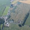
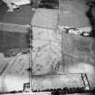
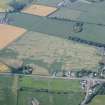
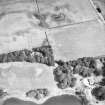
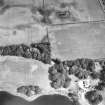
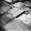
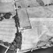
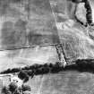
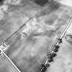
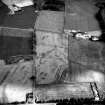
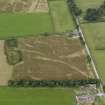
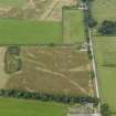
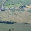
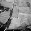
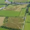
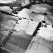
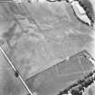
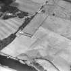
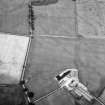
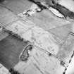
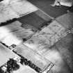
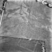
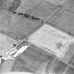
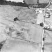
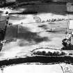
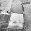
A series of camps has been recorded outside the Roman fort at Glenlochar on the east bank of the River Dee, all discovered as cropmarks by St Joseph in 1949 (1951a: 60– 1). Excavations at the fort have identified three phases: one Flavian and two Antonine, with a further earlier Flavian (Agricolan) fort suspected just to the north of the main fort site (Richmond and St Joseph 1953).
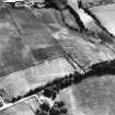
At least five camps are known at Glenlochar, one (V) exhibiting an annexe with an internal partition. St Joseph recorded a further possible two-phase camp in the interior of camp I (Glenlochar VI, see St Joseph 1958: 89; RCAHMS St Joseph Collection: DC 37387–8; and below, possible camps), but this enclosure is probably not Roman in origin.
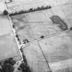
Camp I lies to the north of the fort and measures 260m from WSW to ENE by 238m transversely, enclosing 6ha (almost 15 acres). No clear entrance gaps have been recorded. It intersects camps III and IV and therefore could not have been contemporary with either of these camps, and is extremely close to the perimeter of camp II.
Camp II lies south-east of camp I, immediately ENE of the fort. It measures 355m from WSW to ENE by 294m, enclosing 10.2ha (25 acres). A short length of linear cropmark north of the NNW side may be the remains of a titulus. The course of the Roman road cuts through the northern portion of the camp and a number of quarry pits can be seen in this area. A number of other pits are visible in the interior of the camp, but they do not seem to have much regularity in their structure.
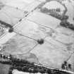
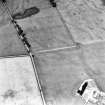
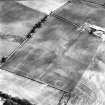
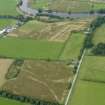
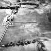
Camp III lies to the north of camp I, and intersects both this camp and camp IV, although the relationship between the three is unknown. Only parts of two sides have been recorded, at least 150m of the WSW side, a rounded southern corner angle and at least 85m of the SSE side. Visible in the interior of the camp is a ring-ditch, which is possibly the remains of a Roman tower.
Camp IV lies to the west of camp III . Only parts of two sides of this camp are known, intersecting camps I and III , and running parallel just inside the NNW side of camp I.
Some 345m of the SSE side has been recorded, together with at least 85m of the WSW side.
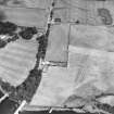
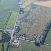
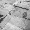
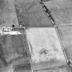
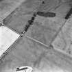
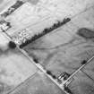
To the south of the group of camps lies camp V, south-east of the fort. Measuring 434m from ENE to WSW by almost 300m, it enclosed 12.9ha (almost 32 acres). Possible entrance gaps are visible in the perimeter but none confirmed. An annexe is attached to its NNW side, measuring some 229m by 78m and enclosing an additional 1.74ha (4.3 acres). This has an internal partition, dividing the internal area to 1.2ha (3 acres) and 0.54ha (1.3 acres) areas. There are a couple of linear cropmarks within the camp but none appears to represent a reduction in the camp, and it is possible that the linear cropmark in the annexe was demarcating different activities in the annexe rather than two phases of use. Alternatively, the cropmark may not be Roman in date, and may represent later use of the annexe enclosure. This camp exhibits a considerable amount of pits in the interior (see section 7f ), and more pits are visible in the area between it and the fort.
R H Jones.

