
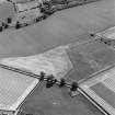
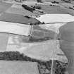
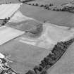
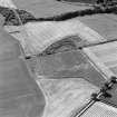
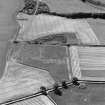
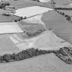
Culvennan


Field Boundary (Period Unassigned)
Site Name Culvennan
Classification Field Boundary (Period Unassigned)
Canmore ID 195344
Site Number NX76SW 55
NGR NX 74047 63916
Datum OSGB36 - NGR
Permalink http://canmore.org.uk/site/195344


- Council Dumfries And Galloway
- Parish Crossmichael
- Former Region Dumfries And Galloway
- Former District Stewartry
- Former County Kirkcudbrightshire
Aerial Photographic Transcription (12 March 2012)
This field boundary has been recorded as a cropmark on oblique aerial photographs (RCAHMSAP 1997). It is depicted on the 1st edition of the OS 6-inch map (Kirkcudbrightshire 1909-10, sheet 72NX76sw).
Information from RCAHMS (KHJM) 12 Mar 2012

