
Kirkcudbright, Moat Brae


Motte (Medieval)
Site Name Kirkcudbright, Moat Brae
Classification Motte (Medieval)
Alternative Name(s) Kirkcudbright Mote; Kirkcudbright Castle
Canmore ID 64081
Site Number NX65SE 40
NGR NX 6831 5109
Datum OSGB36 - NGR
Permalink http://canmore.org.uk/site/64081


- Council Dumfries And Galloway
- Parish Kirkcudbright
- Former Region Dumfries And Galloway
- Former District Stewartry
- Former County Kirkcudbrightshire
NX65SE 40 6831 5109
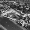
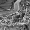
(NX 6831 5109) Moat Brae (NR)
OS 6" map (1854)
Moat Brae: An elliptical mound, about 12ft high on its N and W sides, said to have been the burial gorund of the old parish church.
Name Book 1850
The citadel of Kirkcudbright Mote, the fore-runner of the early 13th century castle (NX65SE 26), probably stood at the highest point in the High Street. Plans indicate that the Mote, elliptical in form NE to SW, extend well past MacLellan's Castle (NX65SE 28). Buildings occupy the north glacis.
J Robison 1926
Mote Brae is as described by ONB. It is known by that name locally. Its present limits are as shown on OS 25".
Visited by OS (EGC) 5 March 1965
Publication Account (1978)
Tradition holds that Fergus, Lord of Galloway, had a castle on Moat Brae in the twelfth century. Nothing above ground remains of this alleged structure, and through the years the site has served as the location for the friary, parish church, as well as work houses and places of business. Further damage to the motte has come through the extension of the line of High Street (Robison, 1926, 47).
Information from ‘Historic Kirkcudbright: The Archaeological Implications of Development’ (1978).
Excavation (11 January 2019 - 5 December 2019)
The Can You Dig It archaeological excavation at Moat Brae in Kirkcudbright was carried out as part of the Galloway Glens Landscape Partnership project and involved input from archaeologists, volunteers and the local community. Though only two small trenches were excavated, the team of volunteers managed to identify at least three phases of activity at the site. The first trench, which was located to the immediate N of Greyfriars Episcopal Church, contained two deposits which were interpreted as either a possible surface/occupation layer from within the 12th-century timber castle/enclosure said to have been constructed by Fergus Lord of Galloway at Moat Brae, or as evidence for the start of the medieval town and burgh of Kirkcudbright. A thick deposit seemed to represent the period after the timber castle/enclosure had been abandoned and possibly related to its reuse as a burial site for the 15th century Franciscan friary, the church of which ('Greyfriars'), was located over the SW portion of Moat Brae. Over the post-medieval deposit lay made ground or demolition deposits which contained several artefacts that dated predominantly to the 19th and 20th centuries, though occasional sherds of medieval pottery and one sherd of post-medieval pottery were also recovered. The final period of the site seemed to involve limited landscaping carried out during the 20th century as the uppermost deposits contained a mixture of artefacts with a varied date range, though they were predominantly of 19th or 20th-century date.
Information from OASIS ID: rathmell1-305876 (L McKinstry) 2019

